
|
|
Mountain/Rock |
|---|---|
|
|
44.63190°N / 9.27530°E |
|
|
Hiking |
|
|
5417 ft / 1651 m |
|
|
Overview
Alfèo is one of the most beautiful mountain of Ligurian Apennine and your summit reach 1651 meters.Your form is similar at a great pyramide.
This mount is entirely in Piacenza province ( Emilia Romagna region ).
The north face is completely cover by trees ( beech-wood ) ( botany, Fagus silvatica )
Last 250 meters of south face are free from the wood and the our efforts are ricompensed by a free view: a splendid panorama toward the initial part of Trebbia’s valley.
 |  |  |
Getting There
The approach to Alfèo is not simple. The distance from any motor-way is conspicuous.If our provenience is the west coast of Liguria exit at Genova Est toolgate and follow the road sign to Piacenza. We meet this villages : Bargagli, Torriglia, Costafontana, Montebruno, Loco, Isola, Gorreto, Bertone. The road mark with a red line.
If our provenience is the est coast of Liguria ( Rapallo toward est ) or a center Italy exit at Chiavari toolgate and follow the road sign to Carasco, S.Colombano Certenoli, Aveggio, Coreglia Ligure, Monleone, Cicagna, Ferrada, Gattorna. After this village, we meet a crossroad and turn left toward Genova.
A tunnel and another crossroad. turn right toward Bargagli, Torriglia, Costafontana, Montebruno, Loco, Isola, Gorreto, Bertone. The road mark with a green line ( Chiavari – Bargagli ), next red line ( Bargagli – Bertone ).
If our provenience is a North west Italy, Piemonte, Val D’Aosta, and west part of Lombardia ( Milano, Pavia, Voghera ) my advice is to run a7 motor-way ( Genova – Milano ) exit at Busalla toolgate and follow the road sign to Casella, Avosso, Casalino, Montoggio, Laccio. The road mark with a purple line. At next crossroad turn toward Torriglia, Costafontana, Montebruno, Loco, Isola, Gorreto, Bertone. The road mark with a red line.
If our provenience is a North East Italy, east part of Lombardia ( Lodi, Brescia, Cremona, Mantova), Veneto and Emilia Romagna, my advice is to run a21 motor way ( Torino, Trieste ) exit at Piacenza Ovest. To escape to Piacenza, follow one of this road signs: SP45 or Galleana Park or Quarto. After this, follow the main road. We meet this villages : Settima, Niviano, Rivergaro, Fabbiano, Quadrelli, Perino, Cassolo, Bobbio, Marsaglia, Ponte Onganasco, Losso, Traschio, Ottone, Gorreto, Bertone. The road mark with a blue line ( Piacenza – Gorreto ), next red line ( Gorreto – Bertone ).
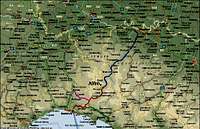 Map of Alfeo
Itinerary
THE SOUTH EAST RIDGE : BERTONE ( 1068 mt ) – TOP OF ALFEO ( 1651 mt ) DIFFERENCE IN HEIGHT 583 mt. ( 1 hour and 30 minutes )The road Gorreto – Bertone is a little country road ( attention ) and your length is 9 km.
I recommended perform this first part of the road with a car.
Bertone ( 1068 mt ) is a little village under the south face of Alfeo. To climb this mountain, follow the FIE signal ( three yellow circle ). The mule-track is stone pavement between fields until approximately 1250 mt of altitude. Here we’ll meet a crossroad. Now, follow a new track : white and red signal at right. The climbing go inside a beautiful beech-wood until the south-east ridge of Alfeo; follow it toward left. A trail near an enclosure conduct at the summit. ( Bertone – Alfeo : 1 hour and 30 minutes ).
 |
Top
The strongly wind touch an aerial summit. Last 250 mt on south face before the top are free from the wood. Great panorama and amazing emotions. At the top, a Madonna statue over a stone cippus sign the summit : 1651 meters. This monument is high 3 meters. |
Meteo
EUROMETEO : Airport of GenovaVIRGILIO METEO
GENOVA 36 km far-away
PIACENZA 56 km far-away
ALESSANDRIA 60 km far-away
Hotel - Overnight Stay
GorretoHotel Miramonti : +39 010 9543000
Ottone
Hotel Nazionale : +39 0523 930100
Hotel Belvedere : +39 0523 930123