
|
|
Mountain/Rock |
|---|---|
|
|
44.49950°N / 9.05010°E |
|
|
3395 ft / 1035 m |
|
|
Overview

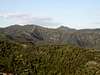
Monte Bano (1035 m) is a summit in the hinterland of the city of Genova, belonging to the Ligurian Apennine.
The top of this mountain is one of the most high of this zone, with Alpesisa ( 989 mt ) at 2 km from Bano, Candelozzo ( 1036 mt ) at 3 km.
Others top are higher than Bano but are distant, so from this top the view is at 360 degrees.
The entirely mountain is cover with chestnut trees, only the top is cover with only grass and rocks.
 |  |  |
Getting There
- To reach by car the starting point for Bano, exit at Busalla tollgate ( Motor-way A7 – Genova – Milano ) and follow SP 226 to Montoggio ( follow a path with a yellow triangle )
- To reach by car the starting point for Bano, can exit at Genova Est tollgate and follow the road signs to Molassana and Piacenza along Bisagno valley.
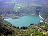
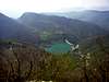
After about 4 km, turn left towards Creto. The road climbs with many hairpin bends and after the village of Aggio reaches the pass 604 m: all around you can see the buildings of the delightful village of Creto. Continue, always by car, along the road descending among green meadows. Turn right, at the sign to Val Noci Lake, the artificial lake, one of the reservoirs supplying the water system of Genova. ( follow a path with a yellow rhomb )
- Is possible to exit at Busalla tollgate and follow the SP 226 to Montoggio. Before this place follow the way to the right from Val Bisagno and turn left at the first bridge on the left after "Tre Fontane". ( follow a path with a yellow rhomb )
 |  |
Itinerary
- FROM CAIASCA ( VAL NOCI LAKE )
Path mark: a yellow rhomb.
Must leave the car near Val Noci Lake ( there is a free parking space ) or continue the asphalt road to little village of Caiasca ( 602 mt ) close to lake some hairpin bend. Here start a large route between the chestnuts. Follow this path and at the first crossroad turn at left. The path continue in plain and after some minutes the trekker can see an old fountain and some old dairy-farm. Near here start on the right the path mark with a yellow rhomb. the way is difficult because the tree are closely like the thorny underwood. Follow the rhomb, the path arrive at west ridge of mount Bano and here other path mark with a yellow triangle descend at left to Montoggio. The trekker must follow the right path, which going up to the top, now visible in front of him. The way is always not simple for the presence of bramble but always good marked. The path continue in half-plane and skirt the mountain from south. The trees now there isn’t and in the last part of the path are visible only rocks and flowers. The path going up quickly at the top of mount Bano at 1035 mt.
- FROM MONTOGGIO
Path mark: a yellow triangle.
Must leave the car at Montoggio ( 438 mt ) and in locality Molino near Balilla place ( where are the bus stop ) find the path mark with a yellow triangle. The way going up to the north side of mount Bano and after 1,5 hour the path meet other path mark with a yellow rhomb. This way descent to Val Noci lake. The trekker must follow the right path, which going up to the top, now visible in front of him. The way is always not simple for the presence of bramble but always good marked. The path continue in half-plane and skirt the mountain from south. The trees now there isn’t and in the last part of the path are visible only rocks and flowers. The path going up quickly at the top of mount Bano at 1035 mt.
 |  |  |  |  |
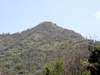
Top
On top of Bano there is a simple wood pole which sign the 1035 mt over the sea level.The top have a circular form.
 |  |  |
Local Meteo
Information Meteosat GenovaVIRGILIO METEO GENOVA
Flowers
Tipical spring flowers see on the ridges of Bano | 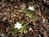 |  |  |