

|
|
Mountain/Rock |
|---|---|
|
|
44.48074°N / 9.04175°E |
|
|
3245 ft / 989 m |
|
|
Overview

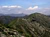
Monte Alpesisa (989 m) is a summit, belonging to the Ligurian Apennine, placed in the hinterland of the city of Genova.
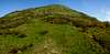
Alpesisa has a flat summit plateau and its form is unique, easily recognizable; at its top one can enjoy the view of both the surrounding mountains and the sea.
The top of the mountain is entirely covered with grass, whereas woods are present at its foot: in particular, at the foot of North Side, near Gola di Sisa (Sisa's gorge) pass, there is a beautiful "Fairy Wood", an old chestnut-wood.
The 27th stage of the "Alta Via dei Monti Liguri" (High Route of Ligurian Mountains), a very long treking route running along all the ridge of ligurian mountains, from Alpi Marittime (west) to North Apennine (east), passes at the foot of Alpesisa, north side.
Some mountains near Alpesisa, are Mount Bano, 1035 mt and Candelozzo, 1036 mt.
 |  |  |  |  |
Getting There

To reach by car the starting point for Alpesisa, exit at Genova Est tollgate and follow the road signs to Molassana and Piacenza along Bisagno valley.
- After about 4 km, turn left towards Creto. The road climbs with many hairpin bends and after the village of Aggio reaches the pass 604 m, where is placed a first trailhead: all around you can see the buildings of the delightful village of Creto.
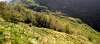
- One can also continue, always by car, along the road descending among green meadows. Turn right, at the sign to Sanguineto, a very small village near the artificial lake called “Val Noci”, one of the reservoirs supplying the water system of Genova. Follow along a narrow road and stop at the first bend on the right: here you can see a small trail entering into a “Fairy Wood”....
- Ignoring the way to Creto, follow shortly as far as Prato, turn left towards San Cosimo and San Martino di Struppa, where, after about 5 km, the road ends.
 |
 |
 | > |  |
Itinerary

Path marks: two blue circles and the symbol of "Alta Via"
From the pass, at the end of the ascending road, go eastwards between two rows of small houses following the "narrow road", that soon becomes a trail and in 1h-1h 15' arrives at a pass with a green meadow, named "Gola di Sisa" (Sisa’s gorge) 729 m.
Here you can see also an old cableway out of work.
One can also get Gola di Sisa:
Path mark: a yellow cross
After a short walk along a gentle slope inside a beautiful chestnut-wood, one arrives at Gola di Sisa.
- It is possible to climb it directly along steep meedows ( see photo ), sometimes it can be necessary to scramble. Take into account that wind is often present. Arriving in view of the summit of Alpesisa, you can catch sight of a curved metallic cross.
- From Gola di Sisa follow towards NE along the "Alta Via" trail running pleasantly in a wood at a higher level than the trail marked by a yellow cross. Be careful to pick up, on the right, the steep trail that, ascending through more and more sparser wood becoming afterwards a meadow, leads you, with fine views of Val Noci lake at your back, to the top of Alpesisa without any difficulty.
Ignoring a further marked path leading to the village of Capenardo that runs along the east slope of Alpesisa without touching it, here one can choose between two different paths:
- the first one, marked by a red cross, leads in 1h 15'-1h 30' to Gola di Sisa
- the second one, marked by two rhombs, in a couple of hours after Monte Pian di Croce leads directly to Alpesisa summit climbing the wide SSE ridge along a steep trail. One must pay attenction to the electric enclosures at low voltage placed to protect sheeps and cows to fall down the scarp.
There are insulators consisting in black plastic pieces which must be used to go beyond the enclosure. It's important to close the gate after the passage.
DIFFICULTIES : before Mount Pian di Croce, there is no difficulty: the trail is sometimes steep and crosses stony grounds. After Pian di Croce the scenery change. The trail goes always along the ridge's limit ( the right wall is a very deep and steep ) one must pay attention in case of wind in particular near the summit. A suggestion? In such a case use also your hands and mantain a low position of the body with respect to the ground.
 |  |  |  |  |
Top
The top of Alpesisa is a flat ground, placed at 989 m over the sea level. |  |  |  |  |
Flowers
Typical flowers on ridges of Alpesisa |  |  |  |  |
Local Meteo
Information Meteosat GenovaVIRGILIO METEO GENOVA
 |  |  |
Alpesisa in Winter

Alpesisa East side from Mount Lago.

Snow on Alpesisa

november 30, 2005 : first snow on the north west ridge of Alpesisa.

Sunset sequence towards Alpesisa from the southern route to Diamante
(Jan 02, 2006)
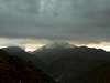
Bad Weather, Amazing Black Reflexes
With the bad weather Alpesisa assumes an incredible austerity, as big mountains."...From the top of mountain a taut whiff of snow and clouds.
I’m at starting point of path. Will i be able to arrive to the summit?
It would be better to try another day!"
 |  |  |
Acknowledgements
I thank LIVIOZ to success of my first page!!External Links
- Alpesisa Itinerario CAI
- Google Video. From Creto to Alpesisa
- Meteo Genoa
Information Meteosat
- Meteo Liguria
It's the official meteo site of Regione Liguria run by ARPAL-CMIRL
- alta via dei monti liguri - trail n.27: Colle di Creto- Passo della Scoffera
It 's a short description (in English ) of the 27th stage of the Alta via dei Monti Liguri, a very long treking route running along all the ridge of ligurian mountains, Alpi Marittime (west) and Apennine (east)