
|
|
Mountain/Rock |
|---|---|
|
|
48.63431°N / 122.33896°W |
|
|
Skagit |
|
|
Hiking |
|
|
Spring, Summer, Fall, Winter |
|
|
1315 ft / 401 m |
|
|
Overview
Alger Alp is an unofficially-named peak located in Skagit County, Washington. Also nicknamed "Little Baldy" by locals, Alger Alp is perhaps most notable as being one of the lowest-elevation peaks crossed by the Pacific Northwest Trail (PNT). For those heading west along the PNT, this is the next peak encountered after passing over nearby Anderson Mountain. The peak is also known for its distinctive cliffband of rock stratigraphy located on its upper west slopes that can be seen from the I-5 freeway. Alger Alp, With Its Distinctive Cliffband
Alger Alp can be summited year-round, regardless of weather conditions. The entire route is via an old logging road which is granted public access, making this a nice short training location or destination for amateur hikers. The summit route is only ~1.5 miles each way, with ~1025' of elevation gain.
 Road-1000: Summit Route and Partial Route For PNT
The PNT follows most of the Alger Alp summit route, between the entrance gate and along Road-1000 until its intersection with Road-1300. The entire summit route uses Road-1000 until its end at a west-facing overlook atop a cliff. Be careful not to get too close to the edge of the cliff, as a fall is very possible and can be deceptively unstable and slick. The true summit of Alger Alp can be reached by following one of a couple of short trails from near the road-end. The trails lead to an small open area near the summit. The true summit is a bushwhacker's dream, but only a short amount is necessary.
 True Summit
 West-Facing Viewpoint Near Summit
Getting There
1) Along I-5, take Exit 240 (located halfway between the cities of Bellingham to the north and Burlington to the south).2) Head east along Lake Samish Road.
3) After 0.7 miles, a stop sign intersection is encountered. Continue driving straight. After the intersection the road name becomes Alger-Cain Lake Road.
4) Within 0.2 miles further, the gated entrance road, Road-1000, is found on the left (north) side of Alger-Cain Lake Road. Road-1000 occurs shortly after Corbell Lane (private residential road) and prior to Silver Creek.
5) Parking in front of the entrance gate for Road-1000 is not allowed. Please park any vehicle(s) in the small automobile pullout on the right (south) side of Alger-Lake Cain Road just prior to the small bridge that crosses over Silver Creek.
 Entrance Gate For Road-1000
Red Tape
No motorized vehicles allowed.No camping allowed.
 PNT Sign
Camping
No camping is allowed on Alger Alp.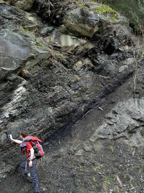 Geologic Rock Uplift Along Route