
|
|
Mountain/Rock |
|---|---|
|
|
48.97716°N / 120.06673°W |
|
|
Okanogan |
|
|
Hiking, Mountaineering |
|
|
Summer, Fall |
|
|
8044 ft / 2452 m |
|
|
Overview
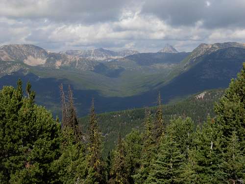
Bauerman Ridge is a seldom summited yet significant peak in the north-eastern region of the Pasayten Wilderness of Washington State. With 1187' of clean prominence and 3.5 miles of ridgeline, Bauerman Ridge towers above many neighboring peaks and trails. In fact, the mountain has a wonderful vantage point for some of Washington's "Top 100" peaks that are located in the Pasayten Wilderness, including Windy Peak, Remmel Mountain, Amphitheater Mountain, and Cathedral Peak. Bauerman Ridge also has the distinction of being the 23rd-most prominent mountain in the Pasayten Wilderness. Bauerman Ridge
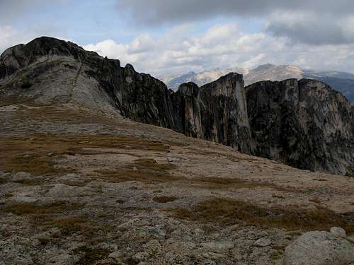
The ridge is named after Hilary Bauerman, a British geologist who helped explore the region during the first Boundary Survey between Canada and the United States from 1857 until 1861. The summit of Bauerman Ridge is only approximately 1.5 miles south of the Canadian border. Much of the mountain is comprised of what is known as Cathedral quartz monzonite, which stretches northwest from the ridge and crosses the Canadian border. Sheer rockfaces and rock walls of granite are found on the eastern side of the northwestern end of the ridgeline. Much geological evidence of glacial drift is found on the mountain, especially on the barren exposed surfaces near the ridgetop.
 Eroded Chasm On Southern End Of Ridgetop
The true summit is located almost directly south of Scheelite Lake, below the northern slopes of the peak. The ridgeline continues northwest of the true summit, looming above the west side of Scheelite Lake, but with much more sheer rockfaces on the east side of that section of the ridge. Of those vertical rockfaces and rock walls on the northwestern end of Bauerman Ridge, the highest and most massive point is called Dr. Johnson Point.
NOTE: This point is not to be confused with the true summit of the ridge.
 Approaching True Summit...
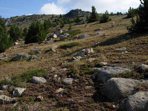
Several summit approaches are possible, with varying levels of difficulty. The simplest hiking approach, as described in the "Getting There" section below, is to ascend off-trail up the southwest side of the mountain to the ridgetop and then northwest along the ridgetop to the true summit. Another hiking possibility is to hike one mile south of Scheelite Pass to the trail's closest point (~7000' elevation) to western side of the ridgeline, and then head off-trail due east up boulder-filled slopes and alpine tundra meadows to the true summit. Yet another possibility is to hike to Scheelite Pass and then head off-trail up and east to the northern end of the ridgetop, and then follow the ridgetop southeast to the true summit.
NOTE: This latter hiking option offers further possibilities to explore the sheer rockfaces on the northwestern end of the ridge, as well as possibly the best route to Scheelite Lake (by hiking around the north slopes of Bauerman Ridge).
 Sheer Rockfaces and Scheelite Lake
Due to the sheer, rocky granitic cliffs located on the northern end of Bauerman Ridge, rock climbers also have further places to explore on the mountain. Rock climbing ascents ranging between Class 5.8 and Class 5.9 are common on this end of the ridgeline, including Dr. Johnson Point.
 Western View From Ridgeline...
Getting There
OPTION #1:
From Tonasket, WA:
1) Drive Okanogan County Road 9437 (Hwy 7) north about 5.5 miles to County Road 9425.
2) Turn west on County Road 9425 and travel about 12 miles to Loomis.
3) From Loomis, continue on County Road 9425 for about 2 miles to County Road 4066.
4) Turn west on County Road 4066, which becomes Forest Service Road 39 (Toats Coulee Road), and continue for 20 miles to Long Swamp Campground.
5) Take FS Road 39-300 for 3 miles to the Chewuch Trailhead (~5600’ elevation).
NOTE: Road 39 is paved for most of the distance to the Road 39-300 junction. Road 39-300 is unpaved.
6) Hike Cathedral Driveway Trail #510A for 2.2 miles, to the intersection with Chewuch Trail #510 (~4200’ elevation).
7) Hike Chewuch Trail #510 for 3.6 miles, to the intersection with Tungsten Creek Trail #534 (~4700’ elevation).
8) Hike Tungsten Creek Trail #534 for 6.2 miles, to the intersection with Boundary Trail #533 (~6750’ elevation). This intersection is located at the site of the Tungsten Mine Camp.
5) Hike approximately 5.5 miles east along Boundary Trail #533 until on the southwestern side of Bauerman Ridge, at approximately 7100' elevation, below the southern highpoint (7925' elevation) of the ridgeline. Then ascend off-trail and north up the steep slopes until at the open upper ridgetop.
6) Once on the ridgetop, hike northwest past several false summits to the true summit (8044' elevation) of Bauerman Ridge.
NOTE #1: The true summit is located almost directly south of Scheelite Lake, below the northern slopes of the peak.
NOTE #2: If done correctly, the off-trail section until the final summit mound is YDS Class 2, but different variations or locations might require some low-level YDS Class 3 scrambling. However, the final summit mound is a solid rocky slope, and requires minor YDS Class 3 scrambling. All other side of the mountain would require serious and competent rock climbing skills.
 Ascending Up Southwest Slope From Boundary Trail...
------------
OPTION #2:
From Winthrop, WA:
1) Drive north on Okanogan County Road 1213 (West Chewuch Road) until it joins Forest Service Road 51.
2) Then drive for 29 miles to the Thirtymile Trailhead (~3600’ elevation).
3) Hike Chewuch Trail #510 for 8.8 miles, to the intersection with Tungsten Creek Trail #534 (~4700 elevation).
4) Hike Tungsten Creek Trail #534 for 6.2 miles, to the intersection with Boundary Trail #533 (~6750’ elevation). This intersection is located at the site of the Tungsten Mine Camp.
5) Hike approximately 5.5 miles east along Boundary Trail #533 until on the southwestern side of Bauerman Ridge, at approximately 7100' elevation, below the southern highpoint (7925' elevation) of the ridgeline. Then ascend off-trail and north up the steep slopes until at the open upper ridgetop.
6) Once on the ridgetop, hike northwest past several false summits to the true summit (8044' elevation) of Bauerman Ridge.
NOTE #1: The true summit is located almost directly south of Scheelite Lake, below the northern slopes of the peak.
NOTE #2: If done correctly, the off-trail section until the final summit mound is YDS Class II, but different variations or locations might require some low-level YDS Class III scrambling. However, the final summit mound is a solid rocky slope, and requires YDS Class III scrambling. All other side of the mountain would require serious and competent rock climbing skills.
 Ascending Up Southwest Slope...
------------
Due to hiking distances, unpredictable weather patterns, and long winter seasons, Bauerman Ridge is best recommended to be attempted between late June to early September. Check with the Okanogan National Forest's Tonasket Ranger District for current trail, snow, and weather conditions at Tungsten Mine Camp.
Bauerman Ridge, and the major routes leading to the peak, can be determined on Green Trails Map #20.
Camping
Backcountry camping is allowed in the Okanogan National Forest and Pasayten Wilderness. However, a backcountry permit must be filled-out (which can be done at any of the major trailheads) prior to entering the area.Backcountry campsites can be found throughout the area, along any of the major established/maintained trails. Campsites are on a "first come, first served" basis, with no reservations.
There are two cabins located at Tungsten Mine Camp, available for overnight stays. The larger cabin has multiple rooms: an entrance room, two bedrooms, and a dining room. Most single-occupants prefer to sleep on the table in the dining room (see "Red Tape" section for the reason why), and the bedrooms would most likely require sleeping on the floor. The smaller cabin, just up the hill and behind the larger cabin, has a single room containing two single beds and one bunk bed. Cabin sleeping spots are on a "first come, first served" basis, with no reservations. Campsites are found in many places around Tungsten Mine Camp, outside of the cabins.
Red Tape
A backcountry permit (free) must be filled-out at any of the major trailheads prior to entering the area.However, Bauerman Ridge lies within a "Fee Use" zone. As of 2009, the fee has been $5 per day, and total amount must be submitted at the trailhead prior to beginning the hike.
Tungsten Mine Camp: There are two cabins available at Tungsten Mine Camp. Please note that field mice are notoriously present in either cabin, even if apparent entrances and openings are closed. It is recommended to try to store food by hanging from various nails in the ceilings and posts within the cabins, or use the "caged" storage box on the outside of the upper cabin. Remember, mice are not afraid to gnaw through gear that has the scent of food. Store gear off floors, as a precaution.