
|
|
Custom Object |
|---|---|
|
|
48.99607°N / 113.65979°W |
|
|
Long Distance Hiking Trail |
Pacific Northwest Trail Summit Post Page
 A custom PNT trailhead sign.
If you think there is important information to add to this page don't hesitate to suggest it. To make suggestions or recommendations please contact the author directly and your suggestions will given full consideration.
About the Pacific Northwest Trail
The 1,136 mile Pacific Northwest Trail (PNT), running from the Continental Divide to the Pacific Ocean, ranks among the most scenic trails in the world. This carefully chosen path is high for the views and long on adventure. It includes the Rocky Mountains, Selkirk Mountains, Pasayten Wilderness, North Cascades, Olympic Mountains, and Wilderness Coast. The trail crosses three National Parks and seven National Forests.History of the Pacific Northwest Trail
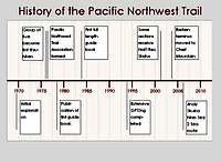 An historical time line of the Pacific Northwest Trail
Thirty years ago the Pacific Northwest Trail was born from the traditions of those earlier trails when Ron Strickland began to seek a way west from the Continental Divide to the Pacific Ocean.
In the late sixties the backcountry experienced an explosion of recreational walking for pleasure. The federal government's changing backcountry management priorities and the new backcountry recreation movement met head on. The result was increased pressure on the relatively few popular trails maintained for outdoor recreation. Maintenance budgets have declined so precipitously that hikers often need Sherlock Holmes' skills to follow some of the old trails.
The bedrock Pacific Northwest Trail philosophy is that local volunteers are the key to development and maintenance. Only they have the grass roots contacts and knowledge to do the job right. Take Max Eckenburg, for example. His grandfather was a timber cruiser in Whatcom County where Max himself was successful decades later in designing our Chuckanut section. In the mid-1980's, Max married Carol Hull, another of our volunteers. They built a homestead on Pontiac Ridge near Mount Bonaparte where Max continued to develop our northeast Okanogan County route. This personal dimension is the essence of the PNT experience.
Map of the Pacific Northwest Trail
 A map of the Pacific Northwest Trail
Montana
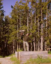 Thru-hiker at trail head.
The walk across Glacier National Park is full of world class views on well-maintained and signed trails. The official route traverses Brown Pass, down to Bowman Lake and onward to the park entrance near the quaint hamlet of Polebridge, MT.
 Glacier National Park as viewed from the West across the valley of the North Fork of the Flathead River.
Idaho
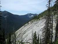 A granite couloir in Kaniksu National Forest, Idaho.
Kaniksu National Forest, the Kootenai River and the Salmo Priest Wilderness are the treasures witnessed in the fifty or so miles spent walking across Idaho's pan handle. It is in this state that the hiker enters another mountain range, the Selkirks.
The wilderness of Idaho's panhandle sees little human traffic aside from the hunting population in the fall. A handful of hot spots for backpacking do exist outside of Bonner's Ferry with trips to areas such as the Ball Lakes attracting crowds of hikers in the heat of the summer.
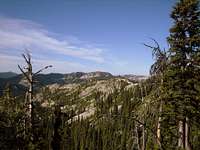 The official route along the PNT contains a few bushwhack sections.
Washington
 PNT trail blaze.
The hiker finds themselves walking the arid desert like country of Northeastern Washington through mountains, hills and river valleys. Along the way they will pass through the well-irrigated Columbia River valley, the spectacular Kettle Crest Trail, the orchard-rich Okanogan River valley and then into one of the penultimate PNT wonders - the Pasayten Wilderness.
The Pasayten is one hundred twenty-five miles of roadless wilderness criss-crossed with the nicely manicured trails of the USFS. The Boundary Trail #533 provides spectacular walking at extended distances over 7,000 feet elevation interspersed by dips down into lush river valleys.
In keeping with the wilderness theme, the Pacific Northwest Trail crosses the Ross Lake Resevoir and then immediately climbs into the Cascade Mountains including North Cascade National Park and the Mount Baker Wilderness Area.
Once out of the hundreds and hundreds of miles of wilderness the trail begins to weave its way in and out of civilization, passing mere miles from the thriving urban center of Bellingham. A quick ferry ride across Puget sound followed by a few more jautns through towns and the hiker once again finds themselves in the heart of the wilderness - this time in the Olympic Mountain Range.
Up and over the Olypics goes the hiker eventually reaching the expansive Pacific Ocean which they have been striving for for over 1,000 miles. The joyous hiker dips their toes in the waves of the Pacific and then slowly savors the last few dozen miles of walking along the beach before completing the Pacific Northwest Trail at Cape Alava on the Western-most point of land in the lower 48 states.
Permits and Red Tape
The vast majority of the Pacific Northwest Trail requires no special planning in terms of regulated, permitted camping. Nights spent on (non-wilderness) National Forest land require no permits and only LNT needs be practiced. Consideration to permits and permission needs attention in the National Parks (Glacier, North Cascades and Olympic) as well as the Pasayten Wilderness and private camping areas (although these can be avoided with some forethought).Glacier National Park - backcountry information North Cascades National Park - backcountry permit information Olympic National Park - wilderness trip planner
Guidebooks and Maps
There is one official guide book to the Pacific Northwest Trail. It was researched and written by Ron Strickland one of the visionaries and original thru-hikers who first conquered the PNT route. His guidebook is entitled Pacific Northwest Trail Guide: The Official Guidebook for Long Distance and Day Hikers.Paperback: 320 pages
Publisher: Sasquatch Books (March 1, 2001)
Language: English
ISBN-10: 1570611777
ISBN-13: 978-1570611773
The official guidebook contains versions of the USFS 7.5 minute quandrangle maps depicting the trail in a bold line. Supplemental maps to consider would be USFS road maps of the area surrounding the trail, hiking maps of the various wilderness areas and National Parks or specialized area maps. These can act as supplements to the route or provide information about lands adjacent to the trail in case an alternate route needs to be considered.