Indecision
I had originally planned on hiking a loop of Elk Lake… a two-day adventure that would include ascending Pinnacle, Blake, Colvin, Nippletop and the Dix’s. However, that would require waking up early on Saturday, and that wasn’t going to happen. On Saturday morning, I had decided to climb East Dix via the Boquet River herdpath that leads to the Great Slide, then over to South Dix, and finally Hough. From there, I would bushwhack down into the Boquet River basin, pick up the herdpath, and hike out. Then, at about 11:00, I was determined to climb South Dix via a Mill Brook bushwhack. Finally, just before I left, I had made my decision… I’d park at the Garden trailhead, hike into the Slant Rock campsite, and climb the
Great Range. Eleven named mountains, eight of which are High Peaks (Marcy, Haystack, Basin, Saddleback, Gothics, Armstrong, Upper Wolfjaw, and Lower Wolfjaw). This would be my most challenging hike to date, but I was up to the challenge.
To Camp
![Red Eft]() A Red Eft along the Trail
A Red Eft along the Trail
The Phelps trail from the Garden to Slant Rock is a wonderful trail, mostly flat with a firm base of dirt… a rarity in the Adirondacks. Just before I reached the Interior Outpost (a ranger station), I saw a mother deer with a (teenage) fawn on the trail. They moved off the trail as I approached, but remained within 20 feet of me. I took some photos, but even with a flash, they didn’t turn out well due to the lack of light. I had my dinner (a peanut butter and jelly sandwich) on the deck of John’s Brook Lodge, and was quickly on trail again. About a half mile from the Lodge, I saw a red eft, who kindly stood still while I took his picture.
I soon came to a rickety and bouncy suspension bridge that could be in an amusement park.
I finally hiked into the Slant Rock campsite at sunset, where I met a French-Canadian couple. They were kind enough to let me use their bear bag, so I gave them some privacy and found a campsite away from the lean-to in which they were staying. It was getting dark, and I was tired, so I got into my sleeping bag as soon as I had set up camp.
A Shortcut
Like last weekend, it was about 30*F at night, and I woke up to a light dusting of fairy dust on the ground. However, unlike last weekend, I was comfortably warm all night, and woke up refreshed. Getting out of my warm sleeping bag at 4:30am took super-human effort, but once I began moving around the cold air lost its punch. I was on the trail at 5:00, just as the sun was rising. Within a couple of minutes, I reached a trail junction. The sign stated that Mt. Marcy was straight ahead, and the Range trail was to the left. Well, I knew I wanted the Range trail, so without much thought, I headed to the left. After about 15 minutes of steep climbing, I realized that I mistakenly took the Shorey Shortcut trail. I contemplated turning around, but I had already gained significant elevation, and I’d have to backtrack the same distance either way. Although I didn’t want to be on this trail, I really enjoyed it. I found this a little odd since it is much maligned by the hiking community… namely because it is steep and ascends a height of land significantly higher than the pass it parallels. I have heard that the trail was named in jest, after a ranger named A.T. Shorey, who was well-known for his “shortcuts” that took twice as long as the established route. I quickly ascended to the height of land, and began a steep descent to the Range trail, which I reached sooner than expected.
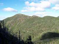
Haystack
![Haystack From Shorey s Shortcut]() Haystack and Little Haystack
Haystack and Little Haystack![The Hillary Step? No! Just a...]() Borrowed Photo
Borrowed Photo![Little Haystack]() Little Haystack from Haystack Col
Little Haystack from Haystack Col
The trail to Little Haystack first descended to a col, and then began climbing at a “comfortable” grade. Although the trail was strewn with boulders, I had no problems with my foot placement, which made for a quick ascent. As I neared treeline, I could hear the wind howling. Since I only had a thin pair of windpants and a long sleeve t-shirt, I accepted the fact that I was going to be COLD on top. The second I got above treeline and began my ascent of the bald peak of Little Haystack (#10), the wind hit me with all its force. As I assumed, the windchill was brutal with temperatures below freezing (there were pockets of ice in some of the small pools of water) and sustained winds of 30mph, with gusts up to about 60mph. I figured I’d be fine as long as I kept moving. I passed over the peak of Little Haystack without stopping, knowing that I’d have to hike over it on my way back from Haystack. As soon as I began descending the peak, a gust of wind nearly blew me down. I figured that the wind was being funneled through the col between Little Haystack and Haystack. However, my brief venture into meteorology didn’t help with my balance on the steep wall I was descending. The blasts of wind continued until I reached the shelter of the trees in the col, where it was surprisingly calm… like the eye of the storm. I was soon being blasted by the wind again as I began my ascent of Haystack. Some of the steep pitches required good hand/foot placement, which was hard with hands that weren’t cooperating due to the cold.
However, I took my time, and climbed the pitches without incident. The views from the top of Haystack were inspiring. Mt. Marcy seemed to be right on top of me, and the view of the Great Range in the opposite direction was equally impressive.
I explored the top for just a couple of minutes, finding shelter behind a steep 5-foot pitch on the southeast corner of the summit. Heading back over the summit to Little Haystack, I was walking directly into the wind.
My face was totally numb, and I thought to myself “This must be what Botox feels like.” The wind had actually stopped gusting, although it was still consistently blowing at 30mph. I took a couple of pictures from the summit of Little Haystack, and continued on my way.
Basin
I retraced my steps back to the intersection with the Shorey Shortcut trail and began my ascent of Basin.
The mountain wasted no time… I immediately began climbing steep pitch after steep pitch, until the trail leveled out in a nice wooded area. This steep-flat pattern continued for the next half mile. When I heard the wind howling again, I knew I was near treeline. I quickly ascended the bald face of Basin, aided by the wind blowing up the summit. The wind on this peak was more inconsistent… going from nearly calm one second to blowing me down the next. As I descended the main summit, I could see over to Basin’s minor peak on the other side of the col. I was a little disheartened at the vertical terrain I had to cover just to get off the mountain.
The hike down into the saddle was very steep, and proper foot placement was crucial. Unfortunately, the moist dirt was sticking to the soles of my trail shoes, and I found myself slipping on the smooth slabs of granite. I had “calculated” some degree of slippage into every step, but one caught me by surprise. As my foot slipped out from under me, I grabbed onto a nearby branch and felt a strain in my left tricep. Although I could feel my tricep tightening up, it wasn’t painful and didn’t hinder my movement. Once in the saddle, I quickly gained the top of the minor peak, and continued to the col between Basin and Saddleback. Again, the descent was very steep, a trend that continued the rest of the day (actually, from now on, when I say that I’m ascending or descending, just assume it is very steep). I plodded down the far side of Basin, carefully placing each footstep. By this time, I realized that it was going to take me longer to descend than ascend the peaks.
Saddleback
Although Saddleback didn’t appear to be overly tall from the col, it rose above me like a wall of granite. I ascended the trail at a constant pace until I reached treeline. I knew that there was a vertical 10-foot pitch at the base of the summit that tested the resolve of many hikers, and soon I was staring directly at it. The pitch would have been much easier if I had been 4” taller, but my 5’7” frame had a hard time reaching handholds/footholds. I found myself wedging my hand into crevasses and grinding my knee into the rock for support. Once over this pitch, I couldn’t find the trail markings on the rock because the sun was in my eyes… so I took what appeared to be the path of least resistance. Long story short, I took the wrong path. On the positive side, at least I got to hone my non-existent rock climbing skills. It wasn’t as gusty on Saddleback as it was on Basin. In fact, the temperature was beginning to climb, and after hours of strenuous hiking, the cool wind was actually feeling good. Once again I decended/ascended/descended the saddle of Saddleback, with very intimidating views of Gothics in front of me.
Gothics
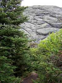
With massive, steep slabs of exposed granite, Gothics is one of the true monarchs of the Adirondacks. An ascent of Gothics alone is a significant and memorable accomplishment for many hikers. Case in point, in 1989 I ascended many of the same peaks I would be climbing today… but Gothics is the only one I actually remember summiting. The trail up the south side of Gothics goes up, straight up, from its base to its southern summit. There are many areas of large slabs with no handholds, and the feeling of exposure is overwhelming to those not totally comfortable with heights. Because of its status, Gothics is one of the more popular peaks in the Adirondacks.
About 100 yards from the col, I encountered the first slab. As I expected, I’d be walking on slab rock the remainder of the ascent to the south peak. Thankfully, my trail sneakers were sticking to the rock like glue, and I had no traction issues on the slabs. Although purely psychological, the feeling of exposure is so great that there used to be cables on the steeper sections of the slabs. Last year, the cables began to fray and the DEC cut them for obvious safety reasons. I wouldn’t have used them anyway… feels like cheating. However, the mountain is steep to a degree that I found myself unable to keep a consistent pace. In order to keep my balance, I found myself charging 30 feet ahead to the next foothold, where I’d rest for the next few seconds, and then I’d charge ahead again. I was going to take a picture of the trail, but decided that the steepness wouldn’t be revealed without a reference point.
The trail from the south summit to the main summit was an easy hike, and I was rewarded with an empty peak. Not once did I think that I would be on top of Gothics, alone, on such a beautiful morning.
The temperature was about 60*F, and the winds had died down to a strong breeze. I savored the views, ate my lunch, changed my sweat-soaked shirt, and took off my wind pants (yes, I had shorts on). I was soon descending the far side of Gothics, on my way to Armstrong.
Armstrong
![Upper Range Panorama from Armstrong]() Upper Range from Armstrong
Upper Range from ArmstrongThe hike to Armstrong was harder than I remembered from my ascent last year. Nonetheless, it was a relatively easy hike, and I was on the summit within 30 minutes. Knowing that I still had two more mountains to climb, I didn’t spend a lot of time on Armstrong’s summit.
Upper Wolfjaw
My pace was now beginning to slow, but I still felt good. I took my time descending Armstrong, and set a consistent pace up to the summit of Upper Wolfjaw. Once again, I had the summit to myself, and rested my legs for a few minutes while basking in the sun. Descending into the saddle of Upper Wolfjaw, I realized that every mountain in this range (except Lower Wolfjaw), had two peaks. I guess that climbing seven High Peaks isn’t enough… why not do ‘em twice?
Lower Wolfjaw
The view of Lower Wolfjaw from the col is intimidating, especially at the end of a long hike. There is nothing “Lower” about this mountain. True, it is 20 feet lower than Upper Wolfjaw, but it is nearly a 700-foot vertical rise from the col, and is unrelentingly steep (not highlighted on map). Again, I set a slow, consistent pace, and after what seemed to be an eternity, I reached the top. There was a couple on top who ruined my bid for being alone on every summit. By this point, however, I really didn’t mind and had a nice conversation.
The End of a Long Day
Since my car was located at the Garden, and I didn't feel like walking from the Roostercomb Trailhead to the Garden, I decided to walk back directly to the Garden. Finding energy in my accomplishment, I easily descended the trail back down Lower Wolfjaw to the col, then down the Range trail to John’s Brook. For a change of pace, I decided to take the Southside trail to the Garden. The parts that followed the old tote road were mercilessly rocky. Thankfully, the trail diverged from the road, and was actually quite pleasant. I probably would have liked it even more if I had done it at the beginning of my hike.
My feet are bruised (not black and blue, but sore), my tricep is still a little tight, and my mid-low back was rubbed raw from by backpack, but the accomplishment of hiking this range significantly outweighs any discomfort I’m feeling.


Comments
Post a Comment