Specifics
Duration: 12 hours; 6:15 a.m. – 6:15 p.m.
Summits: Lower Wolfjaw: 2.5 hours, Upper Wolfjaw: , Armstrong: , Gothics: , 10:00 am; Colden: 12:15 pm
Route: Garden in Keene Valley – Southside Trail (.5 m) – Bennies Brook 2.6 m/700’)– LWJ – Trail to Whack on contour line of UWJ N. Slide – UWJ N. Slide (5.5 m) – UWJ – Trail to Armstrong col – Armstrong Ledges – Armstrong (6.5 m) – Gothics (7.25 m) – Lake Road (10.3 m) – Noonmark Restaurant (15.75 m).
Total Mileage/Vertical Ascent: 15.75/5200
"Trail" Conditions: Dry slides and trail
Temperature: 70’s -50’s
Partner: None…solo hike
Diet: 5 liters water, 1 Optimum Bar, 1 protein bar, assorted nuts, bag dried fruit, 1 MRE.
Clothing: Short sleeve shirt, hiking pants, Merrill Water Shoes/Wright Socks
Pack Weight: 42 lbs.
Summary
This is a bit of a draft trip report, but I wanted to get it on the net…
The original goal for this hike, even at the day’s start, was a complete bushwhack of the Great Range, which I define as Lower Wolf Jaw through Marcy. Opinions vary on that, but that’s my definition for hiking. It didn’t take long for me to realize that I wasn’t in the proper state of mind for such a journey, but I continued. The prior week was mentally draining and I’d hoped to re-channel the energy into this effort. The attempt was earnest, but the result was a skeleton of the original intent, though a tough hike regardless of how it fell short.
Lower Wolfjaw via Bennie's Brook (Root Canal) Slide
Five a.m. marked the beginning of the day. My wife, Deb, agreed to drop me off at the Garden to begin my hike. The day turned out well in the end, but I should have just gone to bed after I backed into the face of a large boulder in my driveway. It didn’t damage the bumper, but the impact launched half the LARGE cup of Deb’s coffee Deb onto my arms, lap and legs.
The .5 mile walk from the Garden to the Southside Trail of the John’s Brook area was eventless and passed quickly. I appreciated the dim woods and early morning chill to the air. The Adirondack summer weather had been either wet or hot and humid. This was a nice break and the sky promised to be a deep Adirondack blue, a color I coveted for hikes such as this. I’d never walked this trail and it met my expectations of a nice grade adjacent to a beautiful brook laced with all the normal flumes and pools normal to the area.
My normal “warm-up” period is usually about a mile. At that distance and time my pace sets itself and my attitude usually adjusts to whatever goal has been planned. I contemplated the day during the 2.6 mile/700 vertical foot ascent to Bennie’s Brook where I’d begin the bushwhack to my first slide. I finally decided that, in the worst case, I’d take my time up Lower Wolf Jaw (Bennie’s Brook Slide ascent) sit awhile at the top and head home if I so desired. The route was such that I could always continue and bail out nearly any point. Retrospectively, the strategy worked well and I felt accomplished in the end.
Bennie’s Brook is a small brook that intersects the larger John’s Brook from the southeast and is located a few minutes past the intersection of the low water/high water confluence of the SS Trail. A small cairn marked a well used herd path which I located at 7:10 a.m. This path meandered along the northeast side of the brook, occasionally pulling several hundred feet away from the water. It was blessedly easy walking up a moderate grade. Half of a watermelon-sized wasp nest rested on the ground about halfway up. Many slides deposit a relatively confined, but deep and obviously violent rubble field. The long and relatively moderately inclined mountainside lent itself to a rather extended rubble field that littered a large tract through the woods.
In less than thirty minutes, I put foot to slab on the mossy Bennie’s Brook Slide. The serpentine slide wound southeastward up LWJ. The right fork could be seen in the shadows as a green scar ascending toward the summit area. The slab began as a very narrow corridor that gradually became what might best be described as a single lane highway…with moss and small ledges. I took my time and fought with the aperture settings on the camera to try and capture both the shadowed details of the slide and the beautiful blue sky in the background. I finally gave it up as a mutually exclusive situation. Lower Wolf Jaw’s shadow shone high on the brothers to the west and mine was a shadowy world of early dawn in a valley.
The slide eventually got wider after pushing through a choked area of debris. As the elevation and width increased, the wind began to pick up and chill my upper body. The temperature was still only in the 50’s. Ledges and an interesting water carved flume added interest to the walk. Vegetation and sphagnum moss grew wherever cracks would allow. Soon the two upper forks of the steeper climb came into view. Satellite imagery intensified my expectations of this slide…not to say it wasn’t interesting or beautiful, but it was not as dramatic as I envisioned. My perspective has changed over the years after hiking so many. This would be a wonderful first slide for many people…it’s exposure was limited and it was long. It also offered what I consider the best and easiest route to the summit, if a short walk “off-trail” to its base is acceptable.
The upper portions were wet underfoot and the growth was taller than I in some sections. It was steep as it ascended the final slopes to the main trail ahead, but not precipitous. The view west showed part of the main slide which then became obscured by woods and snaked toward the now-distant John’s Brook. A very obvious herd path let into the stunted woods and left nothing to the guessing as it led to and intersected the Range Trail just before a short slab climb up the northern false summit. A walk of five minutes placed me soundly on the summit just before 9:00 a.m. There was no one present but me. I surveyed Upper Wolf Jaw’s North Slide. It looked soooooo close. I just couldn’t pass up the opportunity to give it a shot especially after a short rest.
![Bennie s Brook Slide]() ID Pic of Bennie's Brook Slide. Main pic taken from the Brothers in winter of 2003.
ID Pic of Bennie's Brook Slide. Main pic taken from the Brothers in winter of 2003.Upper Wolfjaw via 'Skinny' Slide
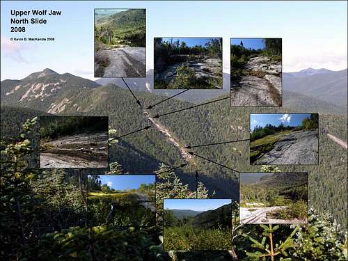
![Slide Shadow]() My shadow upon Upper Wolfjaw's North Slide.
My shadow upon Upper Wolfjaw's North Slide.
UWJ’s north slide looked nearly vertical in my past treks of the Great Range. I took pictures for possible climbs in the future, but gave it no serious thought...until a few months ago when creating a bushwhack route of the Range. The perspective from LWJ with my current slide experience helped me realize the grade was more than acceptable. The trail from the summit to the intersection with UWJ took about twenty minutes as usual. One of the day’s most amusing happenstances occurred while descending the trail to John’s Brook where I met a father and son hiking up to UWJ summit. We talked for a moment and I said have a good one and, “I’ll probably see you up there.” I received a quizzical look since I was descending. As I continued to descend I realized how the comment probably sounded, but as it turned out I did, indeed, see them up there after my slide climb.
The next mission was to locate the slide near the bottom. Two choices presented themselves: bushwhack into the woods or follow the trail until the drainage then bushwhack the stream. I chose the woods and write this direct thought to remind myself of this in the future, “Kevin, follow the drainage when you’ve a choice! Don’t go into the woods.” Anyway, I tend not to use a GPS to follow my track or actively navigate anymore, but prefer to try and read the land. This day, I used the GPS to find the topographical contour line even with the slide’s base, put it away and simply pushed my way to the base. The first two trees I touched foretold of the thousands of blood hungry trees that followed to eat the skin from my arms.
The beginning of the whack was actually not too dense and I made good time for a bushwhack. My goal was to stay on an even average elevation (say 10 times quickly). This worked until the blowdown increased in several areas. I erred on the side of caution by climbing when I had the choice in order to not miss the slide. It was a difficult bushwhack involving balancing on dead trees, climbing small ledges and pushing through trees that prefer not to be pushed until I reached a ridge about 800 feet before the slide. I expected a ridge, but the reality turned out to be small cliffs, ledges and rubble. I poked through the trees and found myself on mossy boulders even with the tops of trees. The forest floor was obscured below. In my opinion, nearly any ledge can be circumvented with patience. This was no exception and trees served as ladders on which I was able to lower myself down the ledges until I reached the boulder caves at the bottom. Trails led toward my goal. The trails had large footprints in places and scat the size of my palm.
The bear trails led toward my destination which was first intersected by a mossy lesser slide. The little strip of “open” in the woods displayed beautiful terraces, but was extremely wet. Several minutes later the true slide and what turned out to be acres of ripe raspberries appeared. Layers of blow-down littered the side of the slide. I couldn’t see anything and wanted to get out of the thick woods. Maneuvering under logs blocking the “trail” further limited visibility. The raspberry field was reminiscent of Kilburn slide’s lower area. The mossy headwall of UWJ North was beautiful in contrast with the dark blue sky. It was too steep to climb, but a scramble up the debris on the right helped the ascent at about 9:45 a.m.
I was ready for a break and climbed up the rough rock until I found a suitable perch. The view of Lower Wolf Jaw was fantastic. Its western ridge obscured but followed the path of Bennie’s Brook. I always find it interesting to see a different perspective of where I’ve recently been. This slide as opposed to others I frequent, had a large amount of garnet, hornblende and diopsite mixed with the stark white base rock. The sandy deposits acted like rough sandpaper which allowed me to simply ascend the steeper sections in a straight line rather than walking cracks as switchbacks for traction. As photos indicated, several distinct headwalls or steeper pitches presented themselves.
This was a beautiful slide, but one of its most unique features was the obvious lack of foot traffic it has received. I didn’t see any pole marks and saw only one weathered footprint. The “herd path” at the top could scarcely be seen. WWBF thinks I imagine most of them anyway, but this one I nearly had to imagine. The whack was not particularly bad when compared with the bottom. It was tight and meandering in nature. As I reached the area near the summit, the pitch declined and I reached some ledges with blow-down on them. Instead of trying to find the path that I knew to be nearby, I ascended the ledges and found the summit at about 10:50 a.m. I took an extended rest while looking at the ledges/slides of Armstrong.
While on the summit (UWJ) a group of three people appeared and stayed about ten minutes. I was wearing a hat with “MudRat” written on the beak. The gentleman asked if I posted to hiking forums under that name. This marked the first time that the trail name was recognized. It was nice that he made the comment and it felt good to put a face with someone who was interested in the things I’ve posted…. The father and son team I saw earlier also appeared briefly.
During several conversations I traded stories ending with the fact that I’d probably just enjoy the day on UWJ and go home to chop some firewood. I ate several types of food and rekindled a spark of my spirit while letting my soaked shirt dry in the sun and breeze. My bail out choices were to go back to the UWJ/LWJ col and hike to either the Lake Road or back to the Garden. My other choice was over Armstrong and to the Lake Road. The wheels of justification turned and I realized that Armstrong’s east slides looked soooooo close!
![Upper Wolfjaw North Slide]() ID of Upper Wolfjaw's North Slide.
ID of Upper Wolfjaw's North Slide.Armstrong via East Ledges
The interwoven hell of Armstrong’s eastern flank didn’t seem so hellish as I walked down the Range Trail toward the col. Finally, as the trail broke west, I bushwhacked east into the woods and around the northern cliffs. The slopes to the south appeared to be a bit less steep. Going was slow as I pushed through the destruction and rubble leading over and down to the narrow drainage. A small ledge descent into the stream’s depression led to the beginning of the end as I started ascending the other side. I kept pushing up and south in a climbing/flanking path. The collective desimation guided me up and I fell a bit off course, but finally came to a slide roughly 40-45 degrees in slope. Retrospectively, I should have continued on the same elevation to the south, but nooooo, I went up and south instead.
The incorrect path led into dense woods rather than the nearby slides and eventually broke through at the base of the first ledge. The trees were relatively clear and allowed fantastic pictures of Giant. That didn’t alleviate the reality that I couldn’t climb the smooth surface of the ledge. No problem, I just followed the base until I found a suitable crack to navigate. This led me to an overhang. I could have crawled under it, I’m sure, but my cautions solo hiking psyche took over since it was about twenty feet to the ground below…the quick way.
Again that prompted me to follow the base north and upward. More rubble, slab and a subsequent push through additional stiff trees awaited. Two nearly vertical climbs up fractured slab and vegetation followed ended the worst of it. While navigating a slab I climbed an upside down tree…never done that before. Finally, the slabs ended and the pitch indicated the summit was near…as did the cripplebrush. I walked onto the Range Trail once again and sat upon the summit at 12:57, content but tired.
The summit rock was croweded with hikers enjoying the sun and views from Armstrong. A strong wind assaulted the various hikers from the west. One group was from Ottawa. The conversation shifted to the rope on my pack. I explained I’ve thus far never used it, but solo slide hiking requires a few precautions especially when the slides are unfamiliar. Soon after, I went on my way. I had it in mind to hike True North Slide on Gothics if (big if) I could find the top of the slide that begins on Gothics and then follows the Gothics/Armstrong col Pictures from Armstrong of me at the head of the slide paralleling True North on Gothics. I didn’t have any idea where the herd path (if any) intersected the Range Trail. I followed several deadends through the sharp trees and finally happened upon the right one. It was faint and haphazard then led sharply down to moss covered boulders and finally the slide top.
I stopped and just surveyed for several minutes watching the Ottawa group on Armstrong who I think saw me based on their actions. Anyway, the conservative solo hiker psyche took over and I let go the thought of bushwhacking Gothics. I was happy with what I’d accomplished and my legs were a bit shaky feeling inside. Some of that was actually water, which I’d run out of on the way down Armstrong. I’d consumed about three literes in six hours.
![Armstrong Ledges/Slides ID Pic]() ID pic of Armstrong's Ledges.
ID pic of Armstrong's Ledges.Gothics and Out
As I walked back up through the woods, I reflected on the day and my next move. Gothics was sooooo close. I dropped my pack near the path and scampered to the summit. It was also a strategic move in that, the best chance for a cell signal was atop the monster…not this day. The hike out got longer at that moment since the chance for a signal until Keene Valley were slim to none. I began the long trek home. Ironically, the hike from the summit to my ride ended up longer in mileage than the adventure in. The path to the Lake Road from Gothics/Armstrong col was the quickest way and progress quickly. I sought a stream to refill my thirst. I found nothing of note until the ground began to level which is where I pulled my first “MacKenzie Maneuver” of the day.
To set the stage, I’d just hiked over/through slides, ledges, sodholes, blowdown, algae etc. and didn’t so much as slip. Finally the trail softened and all-but leveled when I planted my trekking poles on a rock in front of me to guide my steps. The instantly lost their grip on the rock tossing all my weight forward in a mid-air half spin which landed me on my right shoulder and elbow. I bounced again and landed on my pack like a turtle. I counted my fall as a rest and continued to beaver meadow falls where I carefully refilled my water bladder and walked under the falls to cool down.
After a brief walk through the woods to the Lake Road, I quickened my pace. The walk that awaited was a drudgery and began to wear on my feet. Over two miles of dirt road and then over three miles more on Route 73 awaited. Blisters began to cover the soles of my feet midway to the restaurant. Level road walking often does this and the water shoes I had weren’t meant for this type of travel. The last bit of humor awaited just before Noonmark Rest. Where the electronic speed limit sign registered my speed, which made me feel quite slow. I diminished my pace from 4 m.p.h. to 3 m.p.h. just to make sure I didn’t get a ticket before heading for a milkshake.
In my mind I’d already mapped out my next trek…Gothics via rainbow slide-descend cable trail or possibly Ore Bed Slides and up Gothics’ True North slide.
Comments
No comments posted yet.