Details
Duration: 16:50 hours; 6:40 a.m. – 10:30 p.m.
Benchmarks: Sabre Tooth East: 10:10-11:10 a.m., Sabre Tooth West: 11:50-12:10 p.m., White Slide: 12:30-1:45 p.m., Bushwhack to Rainbow: 4:25-5:15, Rainbow Slide: 5:15 -7:15 p.m.
Route: Ausable Club Road – Beaver Meadow Trail – Bushwhack to Sabre Tooth East Base and Ascend – Bushwhack to top of Sabre Tooth West and descend – Bushwhack to base of White Slide and ascend – Bushwhack to Upper Wolfjaw Summit – Trail over Armstrong to top of Beaver Meadow Trail (flat section at 4,000’) – Bushwhack to Cascade Brook and follow to Rainbow Slide – Bushwhack to Gothics’ summit – Weld Trail to Ausable Club Rd.
Total Mileage/Vertical Ascent/Calories: 16 / 6,400’ / 11,000
"Trail" Conditions: Dry trails and slides, moderate water supply in drainages
Temperature/Wind: mid 80’s F / none
Partner: Neil Luckhurst
Diet: 5 litres water, ½ loaf cranberry bread, starburst and a bunch of various bars (sorry lost the wrappers at home)
Clothing: Long sleeve wicking shirt for bushwhacking, short sleeve nylon on slides, ems pants, rock shoes for slides, golite trail runners for trail, hat, golight pack (25 lbs).
PICTURE SETS:
Neil's Pics
MudRat's Pics
Approach
I’ll kick this report off with a list of adjectives that describe portions of the day: incredible, unnerving, breathtaking, sketchy, painful, hot, annoying, tranquil, savage, relaxing, brutal humbling, and fulfilling. That’s the abridged list, but words really can’t encapsulate the experience.
This also turned into an experiment on multiple external and internal fronts. Bushwhacks on the Great Range usually entail at least some brutal conditions. For that, I was prepared, but you never know how it will work out in the end…if you’ll reach your goals within an expected time frame. We met the goals, but grossly exceeded my estimated time-frame of about 12 hours.
My internal (and inadvertent) experiment involved sleep deprivation. I was so amped about the climb that I only slept for about 30 total minutes the prior night and even that was in segments. I’ve operated on 2 hours of sleep before, but never less. It contributed to a few mistakes during the day and clouded my mind a bit, but didn’t ruin the outing by any means. I’d have bailed on the day if I was solo, but couldn’t bear to leave Neil hanging even though he’s obviously fine without a partner.
It took an hour to get rid of the shakes and I awoke while we joked back and forth on the Ausable Club Rd. Conversation then turned to our ever nearing bushwhack. The plan involved deviating from the trail just before it turns hard toward the south to Beaver Brook at about 2,800’ in elevation. Neither of us were using electronics at the time, so we played it by feel, whacked into a drainage and through the conifers into another drainage that “felt” correct. Its alignment and the lay of the ridges looked in order.
The open slab of the stream harbored a pleasant flow of water that ran down various features…the minutiae that make bushwhacking so pleasant. I felt a cold sweat appear and evaporate at a particularly interesting ledge when Neil said, “This looks familiar, but the water is on the opposite side.” I snickered internally and sniped a facetious holier than though comment akin to, “I KNOW we’re on the right drainage…I can feel it!”
Forty minutes later at about 9:40 a.m., the slabs to the south looked surprisingly dark compared to the appearance of the White Slide. There was also too much blue sky to the north through the trees indicating that the northeastern ridge wasn’t as tall as it should be. The profile of the mountains to the west, however, looked correct. Abandoning our “purist” hike, Neil pulled out the GPS after commenting on our imposing itinerary.
I quickly agreed with his judgment. Time was burning. The GPS confirmed our subconscious feelings that we were following a drainage to the Armstrong/UWJ col. Our goal sat a ridge over to the northeast. Armstrong’s slabs and ledges suddenly looked familiar from our location. Neil recognized “his” slide from a hike earlier in the year and I recognized the ledges that I’d climbed in 2008. The bushwhacking over the ridge alternated between pleasant and moderately thick.
The lower portion of the eastern Sabre Tooth Slide appeared to be vertical as it came into view once atop the ridge. A steep whack down to the drainage and over to its base found us changing shirts and refueling at 10:10 a.m. The sun was on a heat setting of 10 and my sleep deprivation experiment was manifesting its first signs…a vicious headache. I ignored it and studied the slab.
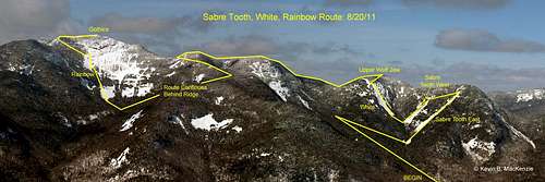
![Sabre Tooth West/East, White and Rainbow Slide Route]() Rough route of our trip...NOT a gps track.
Rough route of our trip...NOT a gps track.Sabre Tooth Slides West & East
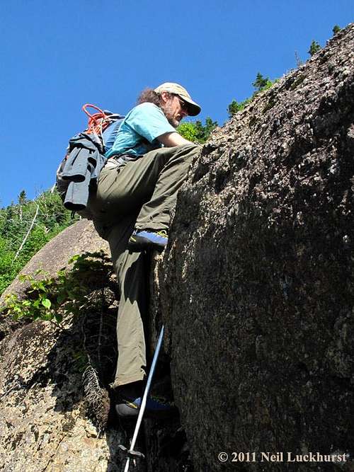
![Upper Wolf Jaw Sabre Tooth Slide East]() Kevin on the lower section of the East Slide.
Kevin on the lower section of the East Slide.
The seemingly vertical slab was really only about 55 or so degrees and riddled with hand and footholds…the perfect playground. The texture was rough, though weathered. Larger grains of anorthosite allowed easy passage if you’re used to exposure. Routes were as numerous as one’s skill. The crux at the top of a conspicuous crack involved a small overhanging ledge climb. We down-climbed and traversed to the east side in an effort to stay alive until later in the day. Atop, we found a more moderately pitched slab.
The White Slide, just over the drainage called our names…”MudRat!...Neil!” I think I heard Neil answer it when he thought I wasn’t looking. It too looked nearly vertical…a trick of perspective once again, but foretelling in retrospect. The white mass “flattened” as we climbed higher. Meanwhile, the Sabre Tooth E. was less than spectacular in the mid portion. Alders filled the cracks and moss grew where it could. The exposed slab was, however, delightfully clean. We climbed quickly as we expectantly neared the base of the head-wall. A ten foot wall of vertical slab met our gaze. I played on a couple ramps as Neil followed the face to a lower portion. Failing on my exploration, I followed his tracks…again.
The head-wall was a fun climb up a series of steep rolling ledges. The rock became a bit more brittle as we climbed. I again tried to climb a vertical crack and found the handholds breaking under even a slight bit of pressure…not worth the time or risk on our first slide. Atop the last pitch, we changed clothing into our bushwhacking armor...long sleeves and gloves.
The bushwhack only last thirty minutes, but the steep grade, a few ledges and blow-down made it difficult. Thankfully, the trees were more open than we later found on Gothics. The slide’s rolling ledges of the head-wall obviously continued west and were underfoot…buried by the moss and duff of the area. Footing required care if we wanted to stay bi-pedal.
Sabre Tooth West
The top of the west sabre was less than spectacular compared to its eastern neighbor. The grade and width of the slab and ledges were a bit less as well.
The main point of interest was nestled in the mid-section. A set of “V” channels diagonally intersected the upper and lower slabs from east to west. The grade changed little once on the lower slab and ended in a vertical foot-wall that petered out at the western side. Moss encrusted rubble littered the drainage, but was home to a small trickle of water which allowed us to refill our semi-depleted supply. Our next bushwhack was a 5-10 minute trek up about 100’ vertical through open forest and up a ledge to the base of the long awaited White Slide.
White Slide
![Upper Wolf Jaw White Slide]() Neil on the upper portions of the White Slide.
Neil on the upper portions of the White Slide.
This beast began at a small field of briars surrounded by dead softwoods. I peered to the top and saw an odd split in the trees where the slide apparently wrapped around the false summit’s southern flank. Ah, something to explore even after the real climb!
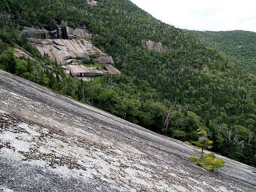
The initial slab was easy to access because of the grade, at least once you find a way around the small hump of anorthosite. Sandy nodules of garnet encrusted the white stone…a trait that was similar to a couple of Dix’ northern slides. This was a mixed blessing that added crystals for traction, but also shed bits of sand in the process. The wide slab was easy to traverse and provided fantastic views of the Sabre Tooth Slides and valley below.
We surveyed the approaching ledges during the ascent and guessed at possible route options. Wide strips of dark lichen and small clumps of dried moss striped the slide, but were easy to avoid…until they weren’t. This happened at an elevation of about 3,775’ or 300’ above the base. Wide open slab lay below as we approached the first of three challenges. The slab was, by now quite steep, nearing 40 or greater degrees at times.
The first difficulty came alongside a ledge that traversed the slide along a northwestern track. Initially, the ledge was wide enough that I couldn’t grab the top. Twenty feet higher, one of the moss bands of moss met the ledge. There was nothing to stop a fall if it turned to dust under our feet. Thus began a few calorie burning moments of holding ourselves in place to find purchase. I finally began to slowly work my way up the ledge inch by precious inch. One hand meagerly gripped the top while I used a finger jam on the bottom. My hands carried the pressure and lightened the load on my feet. A few minutes later, we’d worked our way over the strip and the ledge had narrowed to where I could hop up on the now clean stone.
Just feet higher, we had to cross left to avoid the steeper portions on its northern side. A short, but featureless traverse across the steep face led to another ledge. Fist jams aided the trek up to an area of ample hand and footholds. Multicolored iron stains draped the slab and its many depressions upon which we sat to catch our breath, control our adrenalin and refuel. Tranquil moments of wilderness reflection replaced desperate thoughts of, “Oh, crap, why are we doing this?”
Another ledge ascended the southern side to the final crux. An alternately convex then concave slope in the center of the, now narrow, slide held little feature. I climbed and tested it. My heart said that the quarter inch contours were enough to ensure safe purchase, but my mind fell to the conservative and I backed down and offered to climb around and throw a rope to Neil. Climbing around it involved belly crawling in some more moss with a substantial shelf of trees below to break a fall…which didn’t happen. I then used the trees at the release point as handhold and side stepped to relative comfort while I looped the rope around a small spruce. Neil climbed effortlessly to the top of the slide.
My curiosity wasn’t satisfied, however, since I was now sitting near the aforementioned split in the trees. As if the main event wasn’t enough, we continued on. The split is really an adjacent 100’ slide down to the east-southeast. The entire area was encrusted with copious amounts of dried moss and lichen. Little circles of bare stone allowed us to cut around and to a small ledge. I hopped up with ease. All credit goes to my rock shoes. Neil, in worn down approach shoes was in a fix, however. He’d latched onto the ledge, but the moss turned to dust under him and he began to slide. I grabbed a tree tightly and offered my ski pole to him. He grabbed with full strength and finally stabilized himself enough for the second round of rope climbing. The slab continued around the mountain until it merged with the cliffs. We’d had enough slide. The subsequent 10 minute bushwhack was through loose trees on near level ground. We found the summit at 2:40 p.m. It felt glorious to strip the wet shirt and rock shoes off my body. I tightly strapped them to the outside of my pack with the toes in the outer pockets for further protection.
My attitude was one of reflective exhaustion while on Upper Wolf Jaw’s summit. I was tired from the lack of sleep and from several bouts of holding myself in place on the White Slide. We mutually agreed it was more than we’d expected and considered it quite difficult. We talked and agreed to try Gothics’ Rainbow Slide on the eastern side. I’d been curious about it for many years.
Rainbow Slide and Gothics
![Neil on Gothics Rainbow Slide]() Neil on the upper portions of the "climbable" slab along the left-hand side of the Rainbow.
Neil on the upper portions of the "climbable" slab along the left-hand side of the Rainbow.A slow trek up Armstrong and down the Beaver Meadow Trail led us to a flat section at about 4,000’ in elevation…just past an erratic that was strikingly similar to Slant Rock if not a bit smaller. My mind was pretty much mush from the lack of sleep…I was readily approaching my mental limit. Thankfully my legs weren’t tired. I questioned the wisdom of continuing and considered possible bailout options if necessary. The time was 4:25 p.m. and we had hours of daylight left, so I took the chance. If I’d been solo, my day would have been over at this point.
Neil set a course to head south as we descended through the moderate tree cover. A couple hundred feet down, we followed a drainage until redirecting west as the land flattened. Blow-down was moderate, but tiring, especially when it broke underfoot. The fact that I fell twice emphasized my condition, at least to myself. I also noticed that my vocabulary was shrinking as the day trudged on. I explained to Neil so he didn’t think I was any more insane than normal!
An hour after our whack began, Cascade Brook came under foot. The dramatic slabs of Gothics and Pyramid peeked through holes in the canopy. We, again refilled our water and stomachs at the moss encrusted brook. It was an area of great peace. The flat land, moss, large boulders and multiple drainages created a mystical realm.
Out target was the slab boasting the lowest grade on the cirque’s southern side. A short climb led us to the expansive slab of nearly 300 feet in width. I heard Neil utter, “Holy S***” in awe. We did the clothing change dance for the umpteenth time. It was at this point that I nearly lost my cool. I looked and saw only one rock shoe strapped to my pack. I usually loop the strap through the heel loops of the shoes, but didn’t this time. Considering my options, I donned mixed shoes in hopes that some traction was better than none. A hike is as strong as its weakest link and I was now a very frustrated weak link. Neil demanded a picture as I smirked.
The lower section of the Rainbow was about 650’ long and not even 300’ of vertical climbing; an easy ascent. None-the-less, I avoided the mossy parts and had to keep the trail runner flat for full purchase. I allowed the rock-shoed foot to bend normally and looked like a limping idiot climbing the slide. The steep slabs on Armstrong hung heavily nearby and the cliffs on the ridge were beyond dramatic.
Atop the lower slab was a section of trees where my footwear fiasco became more dynamic and humorous. I now could use the right foot normally (forward alignment) if it was on moss. I had, however, to turn the left “rock shoe” foot perpendicular if it was on moss. Rock shoes are great on rock, but like wearing a banana peel in other cases. We soon changed into our bushwhacking shirts…again. At least Neil did. I’d lost that as well…lack of judgment/lack of sleep to blame.
Exiting the trees onto the mid-section of slab signaled me to proceed with extreme caution. The Rainbow is gently convex as it traverses from moderate to technical near the top. The left seemed to offer the best slope for friction climbing, but moss intermittently covered half the surface. I picked my footing carefully and used the moss several times with only my right foot. The sole was better for this medium. I aimed for the shelves of vegetation and exited stage left at about 4,250 feet in elevation after a rope “rescue” from Neil. I was done, though I watched Neil play on an area before the final ledges turned to cliff.
Our next section began at 6:15 p.m. and was the energy crux of the day. Blackflies had previously been an annoying, but intermittent bother. They mustered a final assault in unison with our attack on the upper flanks of Gothics. The spruce was spaced at about shoulder’s width and sometimes less. Six to eight foot flexible branches grew every foot or so along the trunk. They, therefore, interlaced into mats that were difficult to push through. They were grabby in all the wrong places…shins, waist, shoulders and face. An occasional birch or other non-coniferous tree was thrown in just to add a bit or rigidity. To top it off, the area from slide to trail was a riddle of large and small ledges covered with wet moss. All the while, the blackflies were able to keep pace and invade eyes, ears, hair etc. They were in bite mode though we got the last bite on a few of them. After an exhausting hour or more of grumbling, joking, hacking up blackflies and general discontent while racing the sun, we exited from the trees at the intersection of the Pyramid/Range trail.
A gentle cool wind on Gothics’ summit eased the blackfly bites, dried my clothing, cooled my body and massaged my soul. It was an incredible day. We reflected a bit more on Pyramid and donned our headlamps for the 7 mile walk back to the car…our humour fully intact!
Other Images
![Upper Wolf Jaw Sabre Tooth East]() Neil on lower section of Sabre Tooth East.
Neil on lower section of Sabre Tooth East.![Upper Wolf Jaw White Slide]() Kevin on the upper reaches of the White Slide.
Kevin on the upper reaches of the White Slide.![Upper Wolf Jaw Sabre Tooth Slide East]() Neil on the last leg of the White Slide.
Neil on the last leg of the White Slide.![Gothics Rainbow Slide]() Lower expanse of the Rainbow Slide.
Lower expanse of the Rainbow Slide.


Comments
Post a Comment