
|
|
Area/Range |
|---|---|
|
|
52.27257°N / 3.69827°W |
|
|
Hiking, Mountaineering, Bouldering |
|
|
Spring, Summer, Fall, Winter |
|
|
2467 ft / 752 m |
|
|
Overview
 "Cambria was so called from Camber, son of Brutus, for Brutus, descending from the Trojans, by his grandfather, Ascanius, and father, Silvius, led the remnant of the Trojans, who had long been detained in Greece, into this western isle; and having reigned many years, and given his name to the country and people, at his death divided the kingdom of Wales between his three sons.... to his youngest son, Camber, he bequeathed all that region which lies beyond the Severn, and is called after him Cambria; hence the country is properly and truly called Cambria, and its inhabitants Cambrians, or Cambrenses." Geraldus Cambrensis - Descriptio Cambriae (1194) The Cambrian Mountains of Mid Wales are one of Britain’s largest expanses of wilderness south of Scotland and are the product of thousands of years of interaction between an upland environment, and the few communities which have succeeded in creating their livelihood there. Originally the name “Cambrian Mountains” was applied in a general sense to most of upland Wales, encompassing all mountains from Snowdonia to the Brecon Beacons. It was not until the 1950s that its application has become increasingly localised to the geographically homogeneous Mid Wales uplands of Pumlumon, Elenydd, and Mynydd Mallaen. Due to the areas remoteness and poor transport links (few roads and even fewer houses) it is often referred to as the ‘Desert of Wales’, although it could never be called a desert in the normal sense, since the area recieves considerable rainfall and is characterised by rough open grassland and upland bog, underlain by extensive layers of peat. Many of its valleys have been planted with non-native conifer and in some areas natural and semi-natural deciduous woodland dating back to the Middle Ages still exist. The area is scattered with hundreds of lakes and ponds, both natural and man made. The steep valleys have proved ideal for damming and there are numerous large reservoirs throughout the mountains providing water for the west Midlands of England as well as the surrounding area. The highest mountain in the range is Pen Pumlumon Fawr (752m) located in the north. The northern slopes of the mountain hold the sources for two of Britains most important rivers, the Severn and the Wye. The River Severn (Afon Hafren in Welsh) is Britain's longest river and flows out of the mountains and into England 220 miles to its outlet in the Bristol Channel. The Wye (Afon Gwy), at 185 miles is slightly shorter than the Severn, and also runs south out of the mountains and into England before reaching its mouth at Chepstow, a town that straddles the English/Welsh border. Here the Wye joins the Severn and flows out to sea via the Severn Estuary and Bristol Channel. The area has some of the most beatiful landscapes in the whole of Britain, easily matching those of Britains designated National Parks and Areas of Outstanding Natural Beauty (AONB). In fact in 1965 the National Parks Commission decided that the Cambrian Mountains should be Britain's eleventh National Park; and in 1972 the Countryside Commission (NPC's successor) made a National Park (Designation) Order for confirmation by the Secretary of State for Wales. One notable quote from their report read: "... cut by deep wooded valleys and gorges, their rolling moorlands are colourful at all seasons and are one of Britain's loveliest and most attractive countrysides .... attracting discerning visitors in increasing numbers who appreciate that this 'spirit of Wales' is the equal in beauty of many existing national parks." |


Unfortunately the order was opposed by most of the affected local authorities and farmers, and in 1973 the Secretary of State, Peter Thomas, finally announced his decision not to confirm the Order, to the shock and outrage of the Countryside Commission. The idea was dropped; and it has never been revived, either by the Countryside Commission, or by its devolved successor, the Countryside Council for Wales (CCW). The Cambrian Mountains have therefore been left in limbo: one of the finest landscapes in England and Wales, undeniably worthy of National Park status, and yet completely unrecognised and unprotected, on the whim of a politician. Currently the Cambrian Mountains Society is pushing for the area to be designated an Area of Outstanding Natural Beauty a direction that would give the area the protection it deserves. The landscapes of AONBs are considered to be as important as those of National Parks, the main difference between them being the way they are managed - National Parks are run by an independant park authority in conjunction with the affected local unitary authorites, while AONBs are only managed by the local unitary authoites. |
Areas of the Cambrian Mountains
|
The Cambrian Mountains can be split into three main areas, the Pumlumon region in the north, the Elenydd region in the middle and the area around Mynydd Mallaen in the south. |
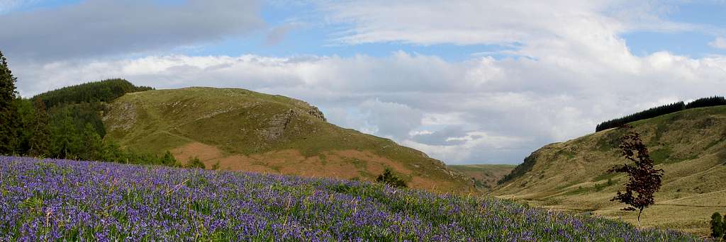
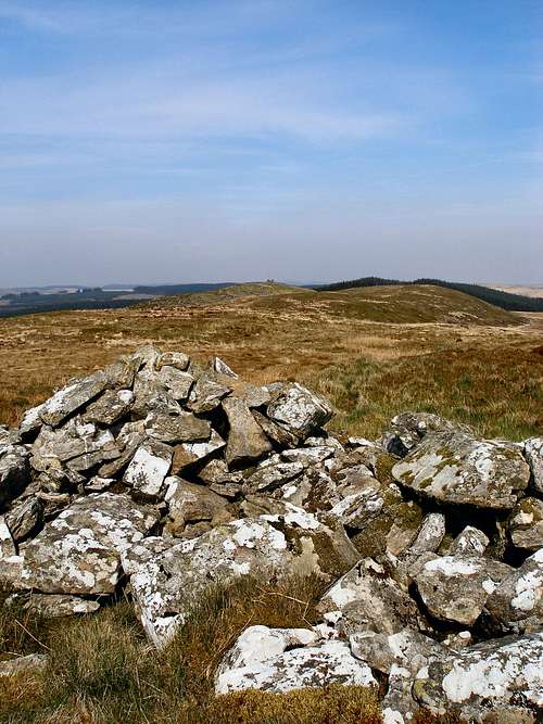
 | The Pumlumon area is in the far north of the Cambrian Mountains, surrounds the Nant y Moch Reservoir, and contains within it most of ranges highest mountains. Pumlumon Fawr is the highest peak and radiates from its highest summit, Pen Pumlumon Fawr (752m), five subsidiary peaks, Pen Pumlumon Arwystli (741m), Pen Pumlumon Llygad-bychan (724m), Y Garn (684m), Pumlumon Cwmbiga (622m) and Pumlumon Fach (657m). Folklore has it that there is a sleeping giant living inside the mountain. Pumlumon also offers the best climbing in the Cambrian Mountains, in the form of a collection of boulders and diminutive crags in the Hengwn Valley. The rock is a coarse, hard sandstone, which has many similarities with the gritsones of the Peak. Unfortunately, a long walk-in over bog is required to reach this venue. |
 | The Elenydd region is the largest and most remote area in the Cambrian Mountains, comprising of a vast area of upland plateau that is broken up by steep valleys. The highest mountain in the area is Drygarn Fawr (645m), which is located just north of the Abergwesyn Valley, one of the most beautiful mountain passes in all of Wales. The vegetation of the uplands mostly comprises of a mixture of Calluna (heather) heath and large expanses of bog and mire. The Upper Tywi Valley is home to the Cambrian Mountains most extensive climbing area, which is centred on the crags and quarries surrounding the Llyn Brianne Dam. The rock is a schisty mudstone, which ranges in quality from okay to abysmal. Most of the routes have been bolted and you’ll thank God that they are. |
 | The Mynydd Mallaen area is located to the south of the Llyn Brianne Reservoir and comprises of a series of rounded hills seperated by steep narrow valleys. It is one of the most important areas of hill country in Wales in terms of bird life, and is dominated by blocks of upland rising to 460m. The uplands are covered by Calluna (heather) heath and mire, with woodland and grassland in the valleys. The valleys are rockier in character then those of the rest of the range, and its cliff faces hold an interesting array of flora, whilst the Quercus (oak) woodland supports many mosses, liverworts and lichens. |
Peaks of the Cambrian Mountains
Obviously, for us here on SummitPost, the mountains themselves are the most important aspect of the range. Despite the areas size the mountains are rarely visited, perhaps because they are hard to access, or perhaps because the area lacks the official designation of a National park its neighbours, Snowdonia in the north, and the Brecon Breacons in the south, enjoy. |
| 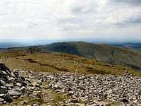 Y Garn Y Garn(Photo by Nanuls) |
This table only lists the peaks that fall within the British definition of a mountain i.e. any hill that exceeds 2000ft (609.6m). As the Cambrian Mountains are mostly made up of upland plateau between 400 and 600 metres this list is a bit thin and does not truly represent the areas landscape. Therefore a more comprehensive list that includes all hills above 500 metres is available here on the Mountains and Promontory Peaks of the Cambrian Mountains page. |
Natural History and People
Geology
The Cambrian Mountains display some of the oldest rocks in Britain. The main strata of the range were laid down 500-400 million years ago, and consist of marine sedimentary rocks, which were deformed by earth movements, resulting in the folding of the rocks, which can be clearly appreciated on the ground in such locations as Pumlumon. Older Ordovician rocks outcrop along the southeastern edge of the Cambrian Mountains, whilst the rest of range is composed mainly of Silurian rocks. Fossils from Mid Wales dating from the Silurian period helped more than a century ago to unravel the time sequence of rocks in Wales and to establish principles now applied globally. The mineral veins (lead, zinc, copper and silver) of North Ceredigion and North West Powys were formed 390 to 220 million years ago, during phases of hydrothermal activity.  Bedrock Geology of Mid Wales Bedrock Geology of Mid WalesOne of the most significant events to affect the landscape was a series of ice ages that occurred during the Quaternary Era, the first of which began around 2.4 million years ago, and the most recent ended only 12,000 years ago. During these periods, the Cambrian Mountains were covered by a deep sheet of ice, several thousand feet thick fed by areas of accumulation in Southern Snowdonia and the Brecon Beacons. Large ice-caps formed on the Welsh mountains, and glaciers occupied the valleys. These ice sheets and their glaciers exploited natural fault lines in the bedrock and carved deeply into the rocks to give the landscape its now familiar appearance. Pumlumon is the ranges best example of a landscape sculpted by glacial ice; Llyn Llygad Rheidol on the north slope of Pumlumon is a moraine-dammed lake occupying a cirque gouged out by ice, and the Elan & Claerwen valleys also owe their origins to this period. The Cambrian Mountains, partly because of the uniform character of their rocks, appear as a dissected plateau broken only by glacial gouging and by the deep clefts of the river valleys. The spectacular gorge and waterfall at Dylife was formed by the deep-cutting headward erosion of the Twymyn-Dyfi to capture the uppermost Clywedog-Severn valley. Similarly, the Teifi was first diverted by rapid headward erosion of the river Ystwyth along the line of the Ystwyth fault, and then the Ystwyth headwaters in turn were captured by the Rheidol. The shortened route to the sea from Devils Bridge (10 miles compared with the previous 50 miles to reach the coast at Cardigan) caused the Rheidol to deepen its bed very rapidly, creating the famous waterfall and gorge at Devil’s Bridge. |
Environment, Archaeology and History
The Cambrian Mountains provide a rare example of a surviving, largely intact prehistoric landscape. Comparatively speaking humans did not reach and exploit the Cambrian Mountains until relatively late following the downwastage of the Late Devensian Ice Sheet. In southwest Wales there is almost no evidence of human occupation during the Lateglacial, or in human terms Upper Palaeolithic, has been found, despite numerous studies and extensive field walking of coastal fringes. Only a single find of a flint specimen has been made at Dôl-y-Bont north of Aberystwyth, which is thought to date from this period. It was found amongst river gravels washed up on the driveway of a caravan park, which has meant that, despite an archaeological survey in the Leri Valley, the stratigraphy it came from is unknown. Typologically it is a core from which flakes have been detached all round, however its size is such as to distinguish it from the smaller cores, which characterize the microloithic industries of the ensuing Mesolithic period. A direct comparison can be made with other settlement sites of the Upper Paleolithic period throughout Europe which provide almost exact parallels as industries based on larger flake-tools, such as may be chronologically equated with the Creswellian culture of Britain. The only other tentative evidence of human activity comes from the presence of charcoal, that may represent human induced fires, within Lateglacial deposits at Bwlch Owen, in the Cambrian Mountains near Lampeter. However this evidence is far from convincing as natural fires (lightning strikes) are an equally conceivable explanation. In southwest Wales the beginning of the Flandrian is dated to around 10.2-10ka 14C BP, a precise calendrical date has not been attained due to the combination of a relatively small number of sites and the aforementioned “radiocarbon plateau” preventing “wiggle matching” to a radiocarbon calibration curve. Unlike the Late Devensian/Lateglacial transition the transition into the Flandrian is much better represented in pollen profiles from the area, providing a relatively detailed picture of vegetational change, much of this evidence coming form the blanket bogs and lake sediments of the Cambrian Mountains. At all sites in west Wales the vegetational succession is marked by a transition from a tundra community dominated by Poaceae (grass family), Artemesia and Rumex to a heathland dominated by Ericaceae (heather family), Empetrum (crowberry), Juniperus (juniper) and Salix (willow) scrub, Betula wood, and by 9ka 14C years BP, extensive Corylus avellana (hazel) and Betula-Corylus (birth-hazel) woodland had developed. Quercus (oak) and Ulmus (elm) also make an appearance around 9ka 14C years BP, the latter arriving first with the former overtaking in dominance forming extensive strands of woodland on hillsides and even on some plateaux areas where Corylus remained a dominant component of the vegetation cover. While Quercus was dominant on the slopes and on upland sites, Ulmus became dominant on the deeper soils of the valley floors. Pinus (pine) is also present in some pollen profiles, although its distribution is more scattered than the other tree taxa found in the area. |

Evidence for human occupation along the current coastline during this period is considered to be relatively strong. A fragment of deer antler found at Ynys-las compares closely with tools belonging to the Maglemosian culture that extended across southern Britain and into mainland Europe, before the severence of the land bridge by around 7ka 14C. By this time both landmasses were not even tenuously connected by mud flats and sandbanks at low tide. The finds dating is strengthened by its find spot which is closely associated with a submerged Mesolithic forest consisting of trees favoured as a habitat by the particular species of deer that bore the antler. The landscape of the Cambrian Mountains we see today is a result of the activity of these people. The first signs of extensive human activity dates back to the early Mesolithic and there is evidence of forest clearing dating back to around 8ka 14C BP. This coincides with evidence of burning in other parts of Britain. Although subject to some conjecture, it has been suggested that these Mesolithic clearances occurred as an aide to hunting, to increase mobility within the forest as well as to drive game into areas favoured by the hunters. Clearing in this way allows the release of nutrients into the soil, creating a rich soil open to sunlight, producing new growth and increased diversity. This increase in grasses and shrubs would increase the number of fauna the area could support; this results in the increased fertility of herbivores and the migration of other animals from surrounding areas. |

Evidence exists of the use of upland sites into the early Neolithic, with the appearance of Plantago lancelota dated 5480 ± 80 C14. Around the beginning of the Neolithic a sharp decline in elm pollen, dated in the area at 5080 ± 80 C14 BP and 4940 ± 80 C14 BP, is recorded in the pollen diagrams. The decline, also recorded throughout Europe, has been attributed to an outbreak of Dutch elm disease, an ascomycete fungus Ceratocytis ulmi. The most recent outbreak of the disease started in Britain in 1965, killing 60% of non-wooldland elms within 13 years. This combined with the affect of the pollarding of leaves for cattle fodder decimated the elm population of the time. Following the elm decline evidence of primitive Neolithic agriculture has been recorded throughout Europe. The growth of blanket peat increased during this period, indicating an increase in forest clearing activity, and leaving a permanent affect on the Cambrian Mountains landscape and environment. During the late Neolithic and Bronze Age forest clearing in the area intensified, and resulted in the local clearance of most woodland by around 1,500 BP. A period climatic deterioration towards the Late Bronze Age early Iron Age (Circa 2,750-2,450 BP, known as the Sub-Atlantic period) bought colder, wetter weather to Britain, leaving exposed areas to experience the intense leaching of soils and a subsequent deterioration of soil quality. This led to a general abandonment of upland sites as agriculture at such altitudes became less favourable, and an establishment of lowland communities, which are still very much evident today. These late Neolithic and early Bronze Age people are responsible for the large number of cairns, individual megaliths, stone rows and stone circles that scatter the uplands of the Cambrian Mountains. The fact that many are sited high on horizons indicates that they were meant to be seen from long distances, possibly for territorial marking, for commemoration of special individuals or for use as foresights for astronomical alignments. |

From the Late Neolithic into the Bronze Age the people of the area began to become more settled and by the Iron Age permanent communities were well established. Evidence suggests that the largest communities were mostly settled outside the highland area of the Cambrian Mountains, farming on the more favorable soils of the west and east. There are numerous small hill forts scattered along the margins including sites at Coed Tangaer (SN 622 479) and Pen y Bannau (SN 741 668). Roman BritainThe earliest known buildings within the mountains are Roman in age. An important gold mine and associated infrastructure e.g. aqueducts, roads and forts, was established at Dolaucothi near Pumsaint (SN 633 402) and operated during the first and second centuries (from AD 75 until around AD 140). This site yields some of the earliest evidence anywhere for the Roman use of a water-powered trip-hammers to crush ore, and was probably worked entiearly by slaves. Insidentaly the mine was reopend in the 19th centuary and operated until 1938. The Roman Road Sarn Helen, which runs from Neath in south Wales to Aberconwy in north Wales, crosses the mountains in the south and can still be driven along in places. Middle Ages to the 20th Century Ystrad Fflur Ystrad Fflur(Photo by Nanuls)  Ystrad Fflur Ystrad FflurBy the late 12th century, with the onset of a slightly more favorable climate, extensive pastures were being grazed by herds of cattle and large flocks of sheep, which provided the Cistercian abbey at Strata Florida (Ystrad Fflur) with its principal income. There had been an abbey in the area since 1164 when the Norman lord Robert fitz Stephen established a daughter house of the great Cistercian abbey at Whitland. In 1166 the Welsh prince of south Wales Rhys ap Gruffydd, conquered Norman holdings in Ceredigion and took control of the area and the Abbey. In 1184 he moved the Abbey to its present location and it grew in importance to become the most important religious establishment in Wales, becoming the burial place for the Welsh royal houses. The Abbey held huge portions of land stretching across the length of the Cambrian Mountains into Powys and Carmarthenshire. Today only the ruins survive including the graves of at least seven Welsh Princes and the now famous richly decorated round-headed west nave of the church. This justly celebrated doorway was originally flanked by a pair of lancet windows, but only one now survives. House platforms believed to date from medieval times are commonplace throughout the area (probably from the late twelfth century), with the best-known settlements occupying the Monastic grange lands of Strata Florida. Evidence collected by Cambria Archaeology and the University of Wales lampeter, from the surviving buildings on either side of the main east-west watershed suggests slightly differing medieval and later building traditions. On the western side, stone and mud were the main materials for buildings roofed with a minimum of timber. Conversely, the eastern side had a relatively timber-rich construction industry, notable for its skilled employment of hardwoods in elaborate house-frames as well as extremely durable roof structures. Much of the area continued to be sparsely populated throughout most of the year, being exploited during the summer months by small dairy farms which began to encroach upon the margins of the uplands in the later mediaeval period, by peat cutting for fuel, by a handful of small lead and zinc mines and stone quarries and by several drovers’ roads taking cattle to markets in the English Midlands, all at their heyday in the 18th and 19th centuries. There are relatively few eighteenth-century manor houses within the area, but the sites of Cwm Elan, Dderw, Dolaucothi, Hafod, Llwyn Madoc, Nantgwyllt, Neuadd Fawr (Cilycwm) and Rhydoldog deserve mention. Although five are now derelict or demolished, three (Dderw, Dolaucothi and Hafod) are registered as gardens or historic landscapes on the Cadw/ICOMOS Register. The important Wilderness Picturesque Landscape Movement grew in the Cambrian Mountains after 1783, from the vision of Thomas Johnes at Hafod. The Hafod Estate, 12 miles south-east of Aberystwyth, occupies some 200 hectares of the Ystwyth Valley and surrounding hills, is recognised as one of the finest examples in Europe of a Picturesque landscape. Its most celebrated owner, Thomas Johnes (1748-1816), built a new house in this remote location and laid out its grounds in a manner suited to displaying its natural beauties in sympathy with the 'Picturesque principles' fashionable at the time, with circuit walks allowing the visitor to enjoy a succession of views and experiences. Johnes also used the land for farming, forestry, and gardening, in each case trying out new ideas and experimental methods. Hafod became an essential destination for the early tourist in Wales. This landscape philosophy is probably best seen as a major antecedent to the wilderness vision underlying John Muir’s imperative to establish American National Parks.  Cwm Hengwm Cwm Hengwm(Photo by Nanuls) From the 18th to the early 20th century mining was widespread but sparsely distributed throughout the area. With few exceptions the mines worked lead and zinc deposits of quite high grade in narrow lodes underground, therefore surface remains are seldom extensive. Pumping and crushing were water powered and the ore concentrates that were extracted were exported via pack trail or rural roads. As no smelting was done on-site, tips are small in comparison with those of the slate industry and essentially of the local rock; there are no slag heaps and no unsightly scars of opencast quarries. Loss of woodland in the region was largely due to agricultural pressure, not mining. A fine example of this industry can be found in Cwmystwyth which has lead mines that are exceptional in the Cambrian Mountains for their enormous scale, accessibility, and age – the workings on Copa Hill are amongst the oldest in Europe. The 20th Century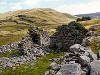 An abandoned farmstead in Cwm Hengwm An abandoned farmstead in Cwm Hengwm(Photo by Nanuls)  Nant y Moch Nant y Moch(Photo by Nanuls) Aside from the construction of several large reservoirs in the 19th century, from the Middle Ages to the 20th century the landscape of the Cambrian Mountains barely changed, with the vast majority of the land given over to agriculture. Over the last 70 years changes in the farming system have led to considerable changes in the way the landscape is managed. In particular the expansion in sheep numbers and the contraction or disappearance of other agricultural activities, especially cattle and pony grazing, has had negative implications for wildlife diversity. The decline of agriculture has led to depopulation and the abandoned farmsteads. Ruined farms can be found throughout the region, visually they are often attractive, but behind that attraction lies the human story of decline and abandonment, with its corollary of the disappearance of schools, shops and community. Since the 1940s coniferous forestry has become an increasingly obvious aspect of the landscape. In the post war years it was thought that in such “marginal agricultural” areas as the Cambrian Mountains, the need for, and financial viability of forestry products outweighed the requirement even for food. The massive expansion of coniferous forestry was often resented by farmers but they lacked the support of the rest of the community. Now, the expectations of financial viability of that forestry are known to have been misplaced, whilst its damaging visual, social and wildlife implications have become obvious for all to see. |
Wildlife
|
The Cambrian Mountains includes a wide range of habitats from the bogs, heather moors and lakes of the upland plateau, down to the native woodlands of the valleys, and the tumbling streams and rivers below. A large proportion of the blanket bog in Wales is found here, as well as very significant areas of upland and lowland wet and dry heathland and some fine examples of Atlantic oak woodlands clinging to the hillsides. Also on the valley floors there are still some superb wet woodlands of willow and alder and a variety of fen habitat types. |


These habitats are rich in wildlife with over 100 species of breeding bird recorded, 35 mammals, 30 butterflies, 20 dragonflies and damselflies, 350 species of lichen, 300 of mosses and liverworts, 30 ferns, 450 flowering plants, 40 hoverflies, 10 ladybirds and 15 different dung-beetles! Many are rare in Wales and within the UK and some are of international importance. In all 35 are on the UK and Wales Priority/Principal Lists including the golden plover (nearly all of the Welsh population are now found in the Cambrian Mountains), black grouse, otter, the climbing corydalis weevil and several rare fungi and upland lake water plants. The higher hills have merlin and dunlin breeding as well as a few hen harriers and ring ousel. Although very rare in mainland Wales, there are still a few colonies of red squirrel, and the polecat is a widespread species. Possibly one of West Wales’ most enigmatic icons is the once extremely endangered Red Kite or boda wennol (swallow-tailed hawk). The Cambrian Mountains were the last refuge of this beautiful bird in the British Isles, which were down to just a single breeding female during the 1930s. It is thanks to the areas wildness, and the hard work and dedication of a few local enthusiasts and farmers that saved it from extinction within Britain’s shores. Even as recently as the 1970s you could travel all day in mid-Wales and not see a single red kite but today following the widespread appreciation of this magnificent bird and strict conservation measures, it is now thriving in Wales and has been reintroduced to several parts of England and Scotland with great success. The red kite was voted overwhelmingly as “Bird of the 20th Century” by members of the British Trust for Ornithology and the RSPB. |
Nature Conservation
| Site Name | Area (ha) | Latitude | Longitude | Grid Reference | |
|---|---|---|---|---|---|
| Afon Tywi/ River Tywi | 363.45 | 51 55 12 N | 03 54 41 W | SN 687 263 | |
| Coedydd a Cheunant Rheidol/ Rheidol Woods and Gorge | 229.19 | 52 23 37 N | 03 50 23 W | SN 748 789 | |
| Coetiroedd Cwm Elan/ Elan Valley Woodlands | 439.53 | 52 15 44 N | 03 34 44 W | SN 923 638 | |
| Cors Caron | 862.03 | 52 15 24 N | 03 55 00 W | SN 691 638 | |
| Cwm Doethie – Mynydd Mallaen | 4122.29 | 52 05 48 N | 03 49 49 W | SN 747 458 | |
| Elenydd | 8609.42 | 52 19 09 N | 03 43 36 W | SN 824 704 | |
| Grogwynion | 42.11 | 52 19 48 N | 03 53 41 W | SN 708 719 | |
| River Wye/ Afon Gwy | 2234.89 | 52 01 24 N | 03 17 59 W | SO 109 369 |
| Site Name | Area (ha) | Latitude | Longitude | Grid Reference |
|---|---|---|---|---|
| Elenydd – Mallaen | 30022.14 | 52 16 07 N | 03 43 39 W | SN 735 446 |
| Site Name | Area (ha) | Latitude | Longitude | Grid Reference |
|---|---|---|---|---|
| Cors Caron | 865.56 | 52 15 35 N | 03 55 00 W | SN 685 635 |

Cors Caron (Photo by Nanuls)
Threats and Issues
The Cambrian Mountains Society has identified four main issues that currently threaten the landscape of the Cambrian Mountains. Wind Power
 The Cefn Croes Windfarm The Cefn Croes Windfarm(Photo by Nanuls) The largest windfarm in the area is the Cefn Croes power station, which opened in 2005, and is built on a high plateau in the heart of the Cambrian Mountains. Despite huge opposition, and despite the advice of the officers of the local planning authority that it should not be permitted because of its impact on the environment and landscape, the development was approved. The development has 39 turbines, each 250 feet high, with 1.5 megawatt "installed capacity" creating a total “installed capacity” of 58.5megawatts.  SSA D SSA DIn July 2005 the Welsh Assembly Government (WAG) published Technical Advice Note (TAN) 8: Renewable Energy (2005). This TAN indicates that there are only a few relatively unconstrained areas in Wales that are capable of accommodating large wind power developments. These areas make up the 7 Strategic Search Areas (SSA) capable of accommodating large (>25MW+) wind power developments. Unfortunately one of these 7 areas is Strategic Search Area D Nant-y-Moch, which the TAN suggests have an “indicative generating capacity” of 140MW (approximately 50-70 modern wind turbines of 100m in height). The area that this SSA covers is some of the ranges most spectacular scenery and it is only a matter of time before the area is developed and its natural beauty is compromised. There is also an ill-defined proposal for an enormous power station of around 165 x 2MW turbines in the southern part of the Cambrian Mountains. This area was thankfully excluded from the Strategic Search Areas, apparently because of objections from the Ministry of Defence, which uses it for very low altitude flight training - one of only two such Tactical Training Areas in the UK. This scheme is the brainchild of one Dafydd Huws of Caerphilly, who has set up a body called the Camddwr Trust, and hopes to gain approval for his plans by promising to distribute a portion of the revenue from the windfarm to local communities. Camddwr may yet re-emerge as a threat to the Cambrian Mountains, when the wind power possibilities of existing TAN8 areas have been exhausted, and if experimental work succeeds in perfecting a system which would obviate the threat posed by turbines to the RAF's tactical training requirements. Powys Super-QuarryPowys County Council is in dispute with the Welsh Assembly Government over quarrying near Llanafan Fawr, on the south-eastern fringes of the Cambrian Mountains. The dispute is over two adjacent blocks of hill farmland totalling 1½ square miles, between Builth Wells and Beulah. The north-western block straddles the Cambrian Mountains National Park boundary as proposed in 1970 and is also partly within the Cambrian Mountains Environmentally Sensitive Area (ESA). A small quarry already operates within this block at Cribarth. WAG wants the land earmarked ("safeguarded" in WAG parlance) as a nationally valuable mineral deposit. Powys had originally allowed for quarrying there in its 2004 draft Unitary Development Plan (UDP), but decided to delete it from the final version. Clearly a major quarry would have a devastating impact on the landscape and environment of this attractive countryside, and the Cambrian Mountains Society supports the Powys County Council version of "safeguarding" (i.e. from quarrying and the inevitable huge expansion in road infrastructure and heavy traffic). Elenydd Youth Hostel Closures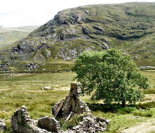 A ruined farmstead in Cwm Hengwm A ruined farmstead in Cwm Hengwm(Photo by Nanuls) The Youth Hostels Association is in the process of closing a number of its Cambrian Mountains youth hostels. It announced in 2005/6 that Blaencaron and Tyncornel would close at the end of the 2006 season, and Dolgoch at the end of 2007. The Elenydd hostels typified the simple accommodation in remote locations which once formed a large part of the YHA network, and which so directly furthered YHA's original charitable aims of helping "all, especially young people of limited means, to a greater knowledge, love and care of the countryside...”. Unfortunately in recent years, YHA has progressively remodelled itself into a provider of budget accommodation in popular locations, and it is no longer willing to subsidise hostels which are under-used, or which fail to fit its modern image. Thanks to local pressure Tyncornel Youth hostel was not closed and can still be booked as accommodation. The Monks TrodThe Monks' Trod links the Cistercian abbeys at Strata Florida in Ceredigion and Cwm Hir in Radnorshire, and is thought to have been the route used by monks travelling between the two abbeys. Older artefacts along the route, such as Bronze Age cairns, have prompted speculation that the route may be much older than mediaeval, though there is no hard evidence to support this. But whether 1000 or 5000 years old, the Trod is certainly one of the most important historic features of the Cambrian Mountains, much of the route having survived - because of its remoteness - with little disturbance until recent times. The section between Pont ar Elan - at the top end of the Craig Goch reservoir - and Strata Florida passes over a wonderful stretch of remote, little-visited moorland, designated as a Site of Special Scientific Interest, a Special Protection Area, and a Special Area of Conservation. It is this 6-mile section which is under threat, and which is referred to in the rest of this page. Today the Trod is classified as a Byway Open to All Traffic (BOAT) on the Radnorshire (Powys) side of the county boundary, and as an unclassified road on the Ceredigion side. In 1990, as a result of widespread alarm at damage to the route caused by the recreational use of motor vehicles, a permanent Traffic Regulation Order (TRO) was placed on the Monks' Trod, banning four-wheeled vehicles only. In 2002, after 12 years of further abuse, another, temporary, TRO was imposed, banning all motor traffic. Since that date, the off-road lobby has been working to ensure that the Order is not renewed, and as a result of their lobbying, Powys and Ceredigion County Councils set up a Partnership "to examine the issues and possible options for the long term management" of the Trod, "examining possible ways forward in managing and utilising the Monks' Trod for recreational purposes". Until recently, the work of the Partnership has been done in private, with representation from landowners (Elan Valley Trust), graziers, Rhayader Chamber of Trade, the Countryside Council for Wales, and off-roader organisations. |
The Welsh Language
The Cambrian Mountains lie in the heart of 'Y Fro Gymraeg' (The Welsh Region), the area of Wales where the Welsh language and culture is strongest. The language is widely spoken in the area, generally the more rural and isolated the village or town is the stronger the language will be. Visitors to the area will therefore definitely hear the language being spoken at some point. Although every welsh speaker also speaks English, if you use a bit of Welsh in conversation it will go a long way. Below are a number of Welsh words and phrases that may come in handy: |
|  Use of the Welsh language in the Cambrian Mountains Use of the Welsh language in the Cambrian Mountains |
Okay, you’re probably not going to need the last few. |
Practical Inforamtion
Mountain Conditions
This section displays the weather forecast for the Drygarn Fawr, which is located rignt in the middle of the mountains. This weather forecast is generated by the Met Office Weather Widget |
When to Climb and Essential Gear
In the spring and summer the weather is usually quite mild and although the weather is usually warm showers are common, and full waterproofs and quality walking boots are essential for all outings. In winter the area is much quieter as most tourists prefer to visit the area when it's warm. In winter conditions an ice axe must be carried and if an attempt is to be made on the harder scrambles a helmet, crampons and a rope are also all essential. Despite the areas comparatively low altitude it can get very cold with temperatures dropping to near Arctic levels, many inexperienced walkers and climbers have been caught out in these conditions most are rescued safely by mountain rescue teams however occasionally the consequences are more serious. |
Mountain Rescue
 Abergwesyn Abergwesyn(Photo by Nanuls) Wales has fourteen Mountain rescue services, none of which operate specifically in the Cambrian Mountains with different services called upon where requiered. They are mostly staffed by local volunteers and funded primarily by public donations. They operate with the assistance of local Police, and in serious situations an RAF helicopter from RAF Valley. The West Wales Air Ambulance also helps out when necessary. The services work is not just restricted to mountain and wilderness rescue; often teams are utilised by the local police to search for missing or vulnerable persons in the community. In emergency situations Mountain rescue services can be contacted by ringing one of the UKs standard emergency service numbers: 999 or 112 |
Red Tape and Access
 Llyn y Gwaith Llyn y Gwaith(Photo by Nanuls) No red tape or access issues here! For climbers, hill walkers and mountaineers, the British Mountaineering Council (BMC) runs a Regional Access Database, which holds mountain/crag specific information on matters of conservation and access, including issues such as nesting restrictions, nature designations and preferred parking: If you are in any doubt about any particular access arrangement, or need to report an incident, you should contact your local BMC Access Representative or the BMC Access Officers for Wales: Elfyn Jones. |
Getting There
As geographically the area is quite extensive, getting there really depends on where you want to get to. The east side of the range is the easiest area to reach, and to base oneself there is a good option. The towns of Llanidloes (SN 955 845), Rhayader (SN 971 680), Llandrindod Wells (SO 060 609), Builth Wells (SO 040 510), Llanwrtyd Wells (SN 878 467) and Llandovery (SN 764 345) are all on the network of ‘A’ roads that run along the eastern margin of the range and all make ideal bases. The western side of the mountain takes a little longer to reach, but does take the visitor close to some of the best landscapes the range has to offer. The towns of Aberystwyth (SN 584 815), Devils Bridge (SN 738 769), Tregaron (SN 879 567) and Lampeter (SN 577 481) offer ideal locations for visiting this part of the range. |


Camping and Accommodation
Despite the areas size there is relatively little provision for camping, details can be found HERE of those sites that are available. There are a couple of youth hostels in ideal locations, Tyncornel (which has only just got electricity) and the Dolgoch Bunkhouse are located miles from the nearest towns and offer true isolation. All the main towns that surround the area, including Llanidloes (SN 955 845), Rhayader (SN 971 680), Llandrindod Wells (SO 060 609), Builth Wells (SO 040 510), Llanwrtyd Wells (SN 878 467), Llandovery (SN 764 345), Aberystwyth (SN 584 815), Devils Bridge (SN 738 769), Tregaron (SN 879 567) and Lampeter (SN 577 481), have numerous hotels and B&Bs in and immediately surrounding them. Wild Camping: The Law in England, Scotland and Wales Tents cannot be pitched just anywhere because every piece of Britain is owned by some individual or some organisation and according to the strict letter of the law permission must be obtained prior to pitching tent and camping. In practice however, this is often impractical and wild camping is usually tolerated in the more remote areas - typically, more than half a day's walk from an official campsite or other accommodation providing you:
|
Resources
Maps
Guidebooks
The Cambrian Way – the mountain connoisseurs walk by A.J. Drake The Mountains of England and Wales: Volume 1 Wales (Cicerone Guide) by John and Anne Nuttall Hillwalking in Wales Vol 1 (Cicerone Guide) by Peter Hermon Hillwalking in Wales Vol 2 (Cicerone Guide) by Peter Hermon |
External Links
 Craig Twrch (Photo by Nanuls) Craig Twrch (Photo by Nanuls) Abergwesyn (Photo by Nanuls) Abergwesyn (Photo by Nanuls)General |