
|
|
Mountain/Rock |
|---|---|
|
|
52.46553°N / 3.78342°W |
|
|
Ceredigion |
|
|
Hiking, Mountaineering |
|
|
Spring, Summer, Fall, Winter |
|
|
2467 ft / 752 m |
|
|
Overview
At 752m Pumlumon Fawr (SN 789 869) is the highest, largest and most prominent mountain in the Cambrian Mountains, and the highest point between Cadair Idris in Snowdonia and Pen y Fan in the Brecon Beacons. The name is often Anglicised to Plynlimon, however, for continuities sake, and because I prefer to use local names on my pages, hereafter it will only be referred to by its Welsh name. At first glance it might seem unremarkable, a broad, boggy, steep sided lump of a hill with a relatively undistinguished summit area. This image is re-enforced by the fact that it is most accessible from the south, its least interesting aspect, and is therefore most often only viewed and climbed from this angle. However, for the more discerning walker, a considerable amount of quality hiking can be found by simply making that little bit of extra effort and driving around to the northern side of the mountain, and lets be fair, driving an extra half an hour isn’t exactly the hardest thing in the world, even if the roads are narrow, windy, and riddled with potholes. The extra effort is definitely worth it; for on the mountain's northern side there are lakes, large crags, boulder-strewn slopes, screes, deep valleys, waterfalls and even mountain ridges. Of course, as is common throughout the Cambrian Mountains, these features are moderately scattered and never dominate the landscape. 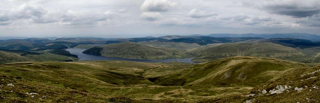  In Welsh, Pumlumon means Five Mountains, which is funny considering the mountain actually consists of six summits, although, it is arguable that two of these, Pumlumon Fach and Pumlumon Cwmbiga, barely qualify as separate peaks, as they have under 30m of prominence. Nevertheless they are worthy of note and command some superb views of the surrounding area. The highest peak is Pen Pumlumon Fawr, which is located towards the centre of the group, and boasts the most interesting features including large cliffs, a ridge (of sorts) and the cirque lake of Llyn Llygad Rheidol. Despite the fact that there are numerous crags at Lluest y Graig and Cwm Llygad Rheidol, which have been described by writers for centuries, rock climbing is in its infancy here, with only a handful of bouldering problems having been properly recorded and described. This, of course, is no bad thing, since it leaves a tantalisingly blank canvas for the adventurous climber to explore. The northern slopes of the mountain hold the sources for two of Britain's most important rivers, the Severn and the Wye. The Severn (Afon Hafren in Welsh) is Britain's longest river and flows out of the mountains, through England for some 220 miles, to its outlet in the Bristol Channel. The Wye (Afon Gwy on Welsh), at 185 miles long, is slightly shorter than the Severn, and also runs south out of the mountains and into England, before reaching its mouth at Chepstow, a town that straddles the English/Welsh border. Here the Wye joins the Severn and flows out to sea via the Severn Estuary and Bristol Channel. Few however, will realise what a place they come from. 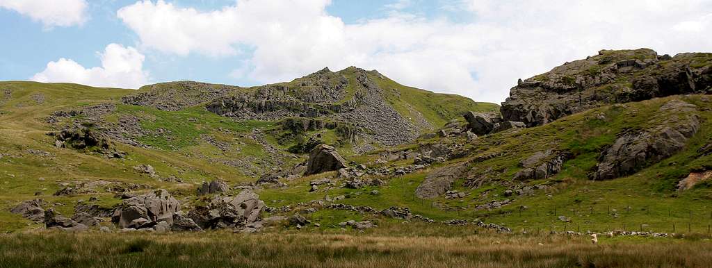 |


Peaks
This table lists the main peaks of Pumlumon Fawr. Only Pen Pumlumon Fawr can truly be called a mountain in its own right as the others are really just subsidiary summits. It is unlikely that anyone walking on the mountain would not visit Pen Pumlumon Fawr, however few people visit the other summits, and this is a real shame as they offer true solitude in a genuinely amazing setting. The map number included in the table is for the Ordnance Survey 1:50 000 Landranger Series sheet that the mountain appears on.
|


Bouldering
 Pumlumon’s climbing interest comes from the collection of boulders and cragletts at Lluest y Graig, which is located some 3km up the Hengwm Valley. The approach is frankly atrocious, taking the form of a monotonous slog across bog where one will find wellies more useful than walking boots. On arriving however, one will be presented with what is probably the best climbing in the Cambrian Mountains; it’s up to you to decide whether or not it was worth the effort. Strewn across the hillside are a number of large boulders and outcrops of hard, coarse, sandstone, which bears much resemblance to the Rhinog Grits of Southern Snowdonia. It’s a delightful rock to climb on, mostly of good quality and mostly free of the vegetation that usually plagues Mid Wales venues. To date, over 60 problems have been recorded here, which range in difficulty from around font 3 to font 6c. Most problems range between font 4 and 5, making it an excellent place to bring beginners. Exploration is still young and there is much scope for new lines, both easy and hard. There’s even scope to put up trad lines on the taller crags that can also be found here, it’s just a matter of someone making the effort to drag their gear all the way out there and giving things a go. A free pdf guide by Steve Muncaster is available on www.midwalesclimbing.com |
Natural History
Pumlumon Fawr is one of the most important upland areas for nature conservation in Wales, being of special interest for its vegetation types and bird fauna. The geology of this upland area is built of Ordovician mudstones, shales and coarse sandstones, overlain by soils ranging from acid brown earths in the better drained parts to deep blanket peat in the wetter places. The principal vegetation types are acid grassland, blanket bog communities and dwarf-shrub heath. Amongst the grassland types is an uncommon one in mid Wales, consisting mainly of sheep’s-fescue (Festuca ovina) with varying amounts of bilberry (Vaccinium myrtillus), fir club-moss (Huperzia selago), alpine club-moss (Diphasiastrum alpinum) and the lichen Cladonia impexa. 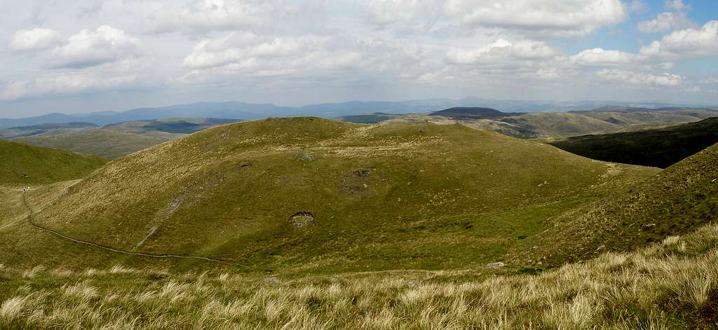 The extensive areas of blanket bog support three distinct vegetation types. In each heather (Calluna vulgaris) is a dominant plant, but in one hare’s-tail cottongrass (Eriophorum vaginatum) is co-dominant, in another deer-grass (Trichophorum cespitosum) and in the third purple moor-grass (Molinia caerulea). The most extensive area of dwarf-shrub heath is around Glaslyn, where heather is dominant, in contrast to areas dominated by bilberry and crowberry (Empetrum nigrum) on and around Foel Fadian to the north. A number of uncommon plants occur in wet flushes and on rocks and cliffs scattered about the site. Starry saxifrage (Saxifraga stellaris) occurs near its southern-most limit in Britain. Most of the birds characteristic of upland Wales are found on the Pumlumon range, either feeding or breeding there. Birds of prey include peregrine falcon, red kite, merlin, hen harrier, short-eared owl, kestrel and buzzard. Ring ouzel, golden plover, red grouse, common sandpiper, wheatear, whinchat and teal breed there, and Greenland whitefronted geese roost during the latter part of the winter on Bugeilyn, the best lake for aquatic plants and animals on the mountain. This wealth of habitat and species means that Pumlumon Fawr and the area around it have been designated as a Site of Special Scientific Interest (SSSI). The site extends from Pumlumon Fawr itself, which is located in the south, to Foel Fadian, which is some distance to the north. |
Historic Landscape
Pumlumon Fawr form part of the Upland Ceredigion Historic Landscape. It’s considered an area where natural forces and human activity, acting together over the last six thousand years, have contributed to produce a landscape of great beauty and variety, which is considered a national asset that is essential both to Wales’ national identity and to its individual 'sense of place' and wellbeing. This very extensive area, which includes the summit of the mountain, lies across the county boundary separating Ceredigion from Powys. Included in this area was part of Cwm-hir Abbey’s Cwmbuga Grange. The unenclosed character of most of this land probably ensured that the Crown claimed it. It included the Crown Manor of Perfedd. Records of Cwmbuga Grange indicate considerable sheep-walks and summer pasture - a function that has generally survived across the whole area to the present day. Though there are now no occupied settlements in the area, historical sources indicate that in the 18th century a pattern of dispersed settlement existed. Many of these settlements were referred to as lluest, which may indicate that their origins lay within a system of transhumance. In 1744, Lewis Morris, the Deputy Steward of the Crown Manor of Perfedd, described them as "small cottages which were originally summer houses for shepherds and have an inclosure of a few acres of ground annexed to them". Morris seems to have described a system in decline as some of the settlements he lists were deserted. By the end of the 18th century they had declined dramatically in numbers, and by the mid 19th century had all but gone leaving a deserted landscape. Plynlimmon Lead Mine commenced production in this remote area in 1866 and continued until 1891. Apart from the metal mines mentioned above, the recorded archaeology consists of Bronze Age round barrows/cairns and find spots, and post-Medieval settlement sites and associated remains. The round barrows/cairns located on summits, such as the group on Pumlumon are dramatic elements of the landscape. Post-Medieval settlements, which are concentrated on the lower slopes, indicate a populated landscape until the 19th century. The area is also the location of one of Wales’ most significant historic events, the Battle of Mynydd Hyddgen, which took place in a valley just to the north of Pumlumon. The battle, which occurred in June 1401, was part of the Welsh revolt led by Owain Glyndŵr (1359–c. 1416) against English rule between 1400 and 1415, and is considered to be the first victory in the field won by the Welsh leader.  The monument commemorating the Battle of Mynydd Hyddgen The monument commemorating the Battle of Mynydd Hyddgen(Photo by Nanuls) The battle began when a large force of 1,500 English soldiers and Flemish mercenaries from Pembrokeshire attacked the army of Glyndŵr, which was encamped at the bottom of the Hyddgen Valley. They had marched north on the orders of King Henry IV in an attempt to quash the growing rebellion, Glydŵr having raised the banner of Welsh independence the September before. Glyndwr had been marching south with a small force of some 120 mounted troops with the aim of pursuing a guerrilla war in the English controlled south. There is only one account of the battle, which can be found in the 'Annals of Owen Glyndŵr' written by the poet Gruffydd Hiraethog many years later in 1550. ”The following summer Owen rose with 120 reckless men and robbers and he bought them in warlike fashion to the uplands of Ceredigion; and 1,500 men of the lowlands of Ceredigion and of Rhos and Penfro assembled there and came to the mountain with the intent to seize Owen. The encounter between them was on Hyddgen Mountain, and no sooner did the English troops turn their backs in flight than 200 of them were slain. Owen now won great fame, and a great number of youths and fighting men from every part of Wales rose and joined him, until he had a great host at his back.” How the Welsh managed to defeat such a large force is unknown, however it may be related to the way the armies fought, the small, light and mobile force of the Welsh, probably armed with bows (the Welsh were famed for their skill as archers), probably outmaneuvered the heavily laden English army which would have been burdened by the presence of women and children and hindered by the boggy valley floor. A monument commemorating the event is located at the Nant y Moch Dam, located several kilometers south of the probable site of the battle. |


Mountain Conditions
This section displays the weather forecast for Bwlch Nant yr Arian, which is located to the westof the mountain. Remember that Bwlch Nant yr Arian is around 300m, while Pen Pumlumon Fawr reaches 752m. This means that when looking at temperature the adiabatic lapse rate must be taken into account, which in Wales is a drop in temperature of between 0.5 and 1°C per 100m in altitude. Exposure and wind speed can significantly lower temperatures. This weather forecast is generated by the Met Office Weather Widget |
When to Climb and Essential Gear
In the spring and summer the weather is usually quite mild and although the weather is usually warm showers are common, and full waterproofs and quality walking boots are essential for all outings. In winter the area is much quieter as most tourists prefer to visit the area when it's warm. In winter conditions an ice axe and crampons should probably be carried. Despite the areas comparatively low altitude it can get very cold with temperatures dropping to near Arctic levels, many inexperienced walkers and climbers have been caught out in these conditions most are rescued safely by mountain rescue teams however occasionally the consequences are more serious. |


Red Tape and Access
No red tape or access issues here! For climbers, hill walkers and mountaineers, the British Mountaineering Council (BMC) runs a Regional Access Database, which holds mountain/crag specific information on matters of conservation and access, including issues such as nesting restrictions, nature designations and preferred parking: If you are in any doubt about any particular access arrangement, or need to report an incident, you should contact your local BMC Access Representative or the BMC Access Officers for Wales: Elfyn Jones. |
Getting There
Pumlumon Fawr is located in the northern Cambrian Mountains, just to the east of the university town of Aberystwyth. The only realistic way to get to Pumlumon Fawr is along the A44, which runs between Aberystwyth (SN 583 185) and Llangurig (SN 908 798). Don’t bother with the southern side of the mountain; turn off onto an unclassified road at Ponterwyd (SN 749 808) and head north towards the Nant y Moch Reservoir. After around 6km turn right at a fork in the road (SN 762 864) and drive along the road until it ends. Park at the end of the road (SN 774 879), it’s impossible to drive any further anyway. Note, that when parking, make sure you're not blocking any of the track entrances that are to be found here. 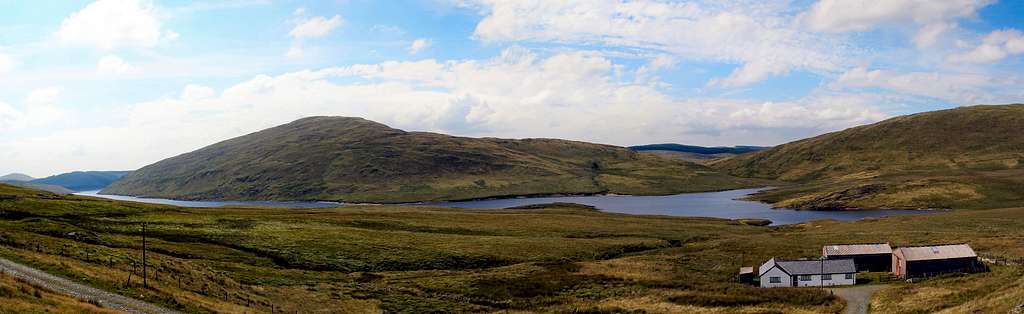 |
Camping and Accommodation
Cheap camping and accommodation is relatively scarce in the local area, although the local towns and villages such as Aberystwyth and Devil's Bridge do offer plenty of options. For a comprehensive guide to the accommodation in the area, Ceredigion County Council's tourism website has some excellent pages providing details on what’s available throughout the area: Ceredigion County Council's Tourism Website In my personal opinion wild camping is the best option, I guarantee you no one else will be camping for miles around. |
Maps
Guidebooks
The Cambrian Way – the mountain connoisseurs walk by A.J. Drake Cicerone Guide: The Mountains of England and Wales Volume 1 Wales by John and Anne Nuttall Cicerone Guide: Hillwalking in Wales Vol 2 by Peter Hermon Pumlumon Bouldering by Steve Muncaster |
External Links
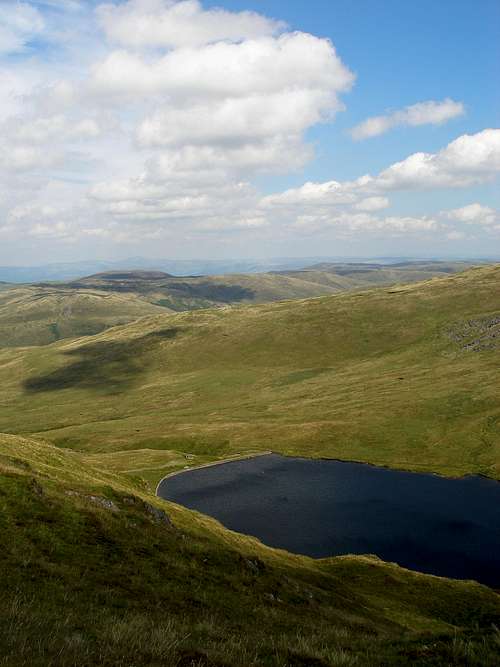 Llyn Llygad Rheidol (Photo by Nanuls) Llyn Llygad Rheidol (Photo by Nanuls)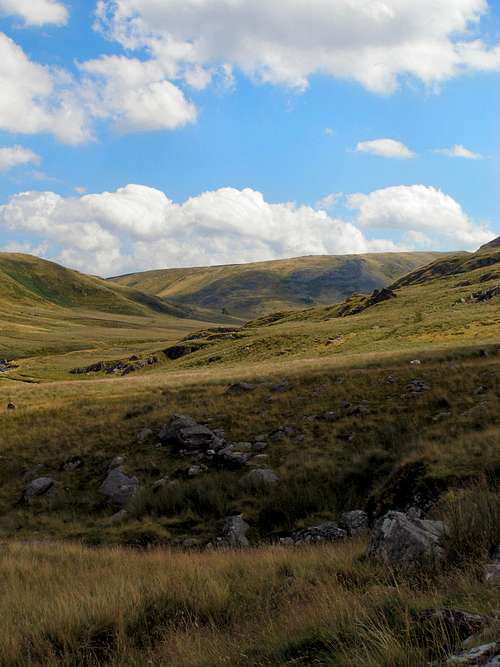 Cwm Hengwm (Photo by Nanuls) Cwm Hengwm (Photo by Nanuls)General |