
|
|
Mountain/Rock |
|---|---|
|
|
52.21181°N / 3.66531°W |
|
|
Powys |
|
|
Hiking |
|
|
Spring, Summer, Fall, Winter |
|
|
2116 ft / 645 m |
|
|
Overview
Top Trumps!
Matterhorn Pointy! | Drygarn Fawr Indistinct! | |
|---|---|---|
So let’s get down to brass tacks as it were, height is important and at 4478m the Matterhorn is a beast by any standard, ranked 23rd in the Alps its quite a mountain. Climbing a mountain of this size will definitely impress the ladies (or gentlemen) down the pub. 10 POINTS | At only 645m Drygarn Fawr only just exceeds 2000ft, making it a small mountain even by the modest standards of the British Isles. Climbing it isn’t going to impress anyone, not even your mam… and she was impressed when you used to make collages out of pasta. 0 POINTS | |
Its unique pyramidal shape makes for an exceptionally stunning and beautiful mountain. With narrow ridges and vertical cliff faces it has everything a mountain should have; the Matterhorn truly is the super-model of peaks. 10 POINTS | Well it doesn’t really have much of a shape at all, it’s more of an amorphous blob than a mountain. It's just a small rounded summit that’s slightly higher than the plateau it sits upon and to be fair, you’d be hard pressed to realise that there’s a mountain there at all. 0 POINTS | |
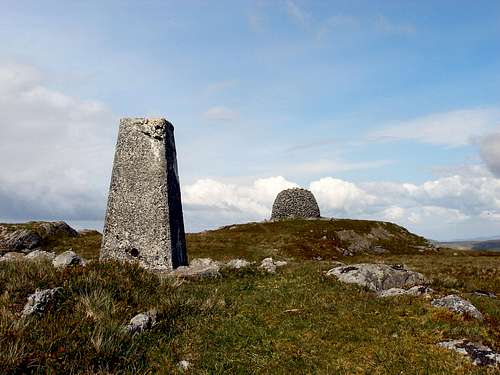
A small summit with great big steep cliffs on every side, the Matterhorn has a proper mountain summit. What more can be said? 10 POINTS | Not so much a summit, as just a slightly higher flat bit, you could land a jumbo jet on it (well maybe that’s an exaggeration but you could get some sort of aircraft on it at the very least). You could quite easily play a game of five-a-side and still have room to spare. It does have a rather nice Stone Age cairn though, which counts for something. 1 POINT | |
With one of the hardest ‘normal’ routes in the Alps, the Matterhorn is a challenge for all but the most experienced of mountaineers. Requiring proper climbing skills whatever way you choose to climb it, there’s no question that when you’re climbing the Matterhorn you’re climbing a real mountain. 10 POINTS | Although quite long, the routes up Drygarn Fawr are very gradual, rising slowly from the valley onto its plateau. There’s no technical climbing and nothing that will particularly excite. They do offer a nice bit of tranquility though. 0 POINTS | |
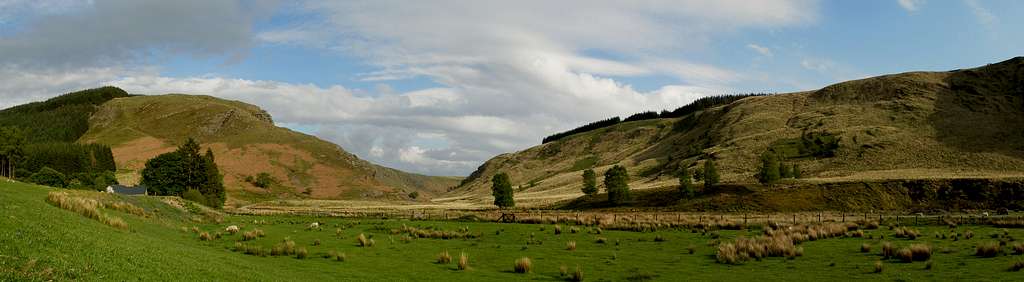
Probably one of the best views in the world – from Mont Blanc, Dent d’Herens and Grand Combin in the west to the northern giants of Dent Blanche, Obergabelhorn, Zinalrothorn and Weisshorn to the Mischabel group with Dom, Taschhorn, Alphubel, Allalinhorn, Rimpfischhorn and Stralhorn and further to Monte Rosa, to the Liskamm and the Breithorn in the east. A resounding 10 points! 10 POINTS | One expansive sweeping panorama of mostly plateau, bog, mire and sky. If you like lots of sky this is great. It sort of lacks scale and has been described as ‘unsettling’ mostly due to the fact that there’re no real landmarks. I like it though. 1 POINT | |
The Matterhorn is one of the most photographed mountains in the world. Sharp, dramatic, and able to instil both fear and awe at the same time, it could have been designed specifically for the purpose of photographing. 10 POINTS | The fact that the mountain doesn’t really have much of a shape makes it a little hard to photograph. But with a lot of imagination and a bit of luck, a great photograph is probably not beyond the realms of possibility. 0 POINTS | |
With Zermatt only a stone’s through away, with all its trains, cable cars and stupid electric buggies wizzing about the place, the base of the Matterhorn is pretty easy to get to and with the Hörnli Hut located just underneath the Hörnligrat Ridge, things just couldn’t be much more convenient. 10 POINTS | It's located right in the middle of nowhere, miles and miles and miles from the nearest village and with only a couple of small roads going anywhere near it. The mountain could hardly be said to be within easy reach. And sod’s law is that you’ll get stuck behind some swine in a tractor or some OAPs out for a leisurely drive and it’ll take even longer. 0 POINTS | |
The Matterhorn gets so many visits that in the summer months, when conditions are right, the main route to the top can feel more like queuing for a supermarket checkout than climbing. Normally this would be a bad thing, but as this is Top Trumps, the greater the quantity the greater the points, so the Matterhorn is awarded top marks! 10 POINTS | Practically nobody visits Drygarn Fawr. Some people might drive around it or picnic next to the reservoirs of the Elan Valley, but few bother to ascend its slopes and cross its bogs to get to the summit. This is one of the mountains strongest points, however this is Top Trumps so its nuls point! 0 POINTS | |
Matterhorn Monte Cervino, Monte Cervino Matterhorn, one mountain, two names, and top marks. 10 POINTS | With only one name, Drygarn Fawr puts in a poor show on the name competition. This is amplified by the fact that thanks to the inability of English cartographers to pronounce or spell Welsh place names, many, many Welsh mountains have two names. Only having one name therefore, is nothing short of disgraceful. 0 POINTS | |
With only steep rocky cliff faces surrounded by glaciers and more steep rocky cliff faces there isn’t much room for wet marshy expanses of land on the Matterhorn. This utter lack of essential wetland badly lets the mountain down, I mean, where is one supposed to bog snorkel? 0 POINTS | Drygarn Fawr has miles upon miles of wet bogland, marshes and mire, extending as far as the eye can see. The car park is surrounded by bog, the plateau surrounding the summit is almost entirely bog, and the summit itself has bog on it. In fact, there’s so much bog, marsh and mire that it would be quite easy to dispose of a body in it and it never be discovered… not that I would ever advocate that kind of thing of course. 100 POINTS | |
Leading throughout, the Matterhorn looked invincible but was let down badly by a complete lack of bog. Something all the pointyness in the world cannot make up for.
| Things were looking a bit shaky for the underdog, however, thanks to a complete over abundance of bog, the mountain trumps home with a resounding and glorious victory. |


There that proves it, Drygarn Fawr is far better than the Matterhorn - you have been told, go climb it! |
Mountain Conditions
This section displays the 5 day weather forecast for Drygarn Fawr. This weather forecast is generated by the Met Office Weather Widget |
When to Climb and Essential Gear
 The Summit
In the spring and summer the weather is usually quite mild and although the weather is usually warm showers are common, and full waterproofs and quality walking boots are essential for all outings. In winter the area is much quieter as most tourists prefer to visit the area when it's warm. In winter conditions an ice axe and crampons must be carried. Despite the areas comparatively low altitude it can get very cold with temperatures dropping to near Arctic levels, many inexperienced walkers and climbers have been caught out in these conditions most are rescued safely by mountain rescue teams however occasionally the consequences are more serious, and every year casualties occur. |
Red Tape and Access
No red tape or access issues here! For climbers, hill walkers and mountaineers, the British Mountaineering Council (BMC) runs a Regional Access Database, which holds mountain/crag specific information on matters of conservation and access, including issues such as nesting restrictions, nature designations and preferred parking. If you are in any doubt about any particular access arrangement, or need to report an incident, you should contact your local BMC Access Representative or the BMC Access Officers for Wales: Elfyn Jones. |
Getting There
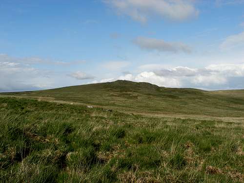 Drygarn Fawr Drygarn FawrDrygarn Fawr is locate right in the middle of the Cambrian Mountains, around halfway between Tregaron in the west and Builth Wells in the east. There are therefore, two ways to get to the mountain, from the west or from the east. If coming from the west you need to go through Tregaron (SN 879 567) and leave the village west along an unclassified road that goes through the pass of Abergwesyn. The road is narrow, endlessly winding and often very steep. Best avoided when there’s snow about. The car park (it’s not a car park really just a lay-by) is at Llanerch yrfa (SN 834 555) in Abergwesyn, you won’t struggle for space there’ll be won’t be anyone else there. If your coming from the east first you need to get to Rhayader (SN 971 680) and drive in a south-easterly direction on the A4518 along the Elan Valley towards the Caban-coch Reservoir. Drive along the northen edge of the reservoir and cross the Garreg Ddu Reservoir Dam and park at the Llanerch y Cawr car park (SN 900 616) at the end of the Caban-coch Reservoir. |
Camping and Accommodation
There’s a campsite in the west just outside Tregaron at Aberdwr (SN 686 596) and there’s a campsite in the east, right on the river Wye just outside Rhayader (SN 968 684). There are also B&Bs and hotels in both towns. The most convenient place for reaching the mountain (its not convenient for anything else) to stay at the Dolgoch Bunkhouse (SN 806 561) which is run by the YHA and is only around 3km away from the bottom of the mountain. |
Maps
| Navigation Maps OS 1:25k Explorer Series 200 Llandrindod Wells & Elan Valley/Llandrindod a Dyffryn Elan OS 1:50k Landranger Series 147 Elan Valley & Builth Wells / Cwm Elan a Llanfair-ym-Muallt Road Maps OS Travel Map 10 North and Mid Wales |
Guidebooks
The Cambrian Way – the mountain connoisseurs walk by A.J. Drake |
External Links
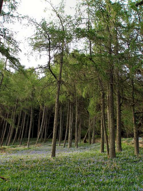 Larch woodland to the south of Drygarn Fawr Larch woodland to the south of Drygarn Fawr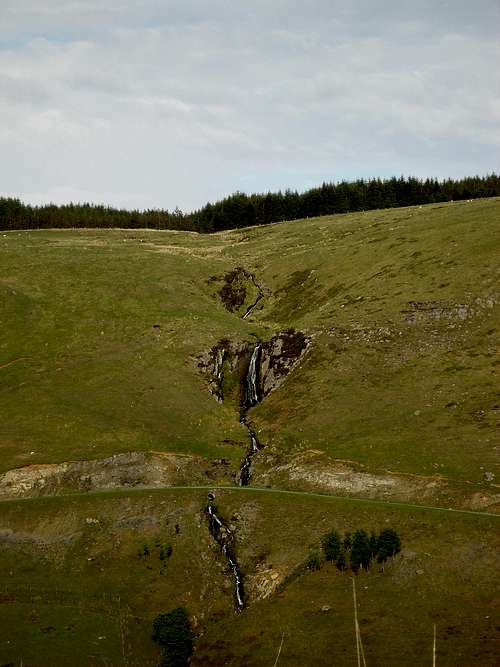 Rhaeadr Nant Ystalwyn Rhaeadr Nant YstalwynGeneral |