


Comments
No comments posted yet.
|
|
Trip Report |
|---|---|
|
|
40.48299°N / 121.50948°W |
|
|
Jul 26, 2007 |
|
|
Hiking |
|
|
Summer |
My son, Curtis, and I were on the second week of our three-week camping vacation. Of course, this is part of our quest to visit all 58 of the U.S. national parks. A couple days earlier we’d been at Yosemite, and had hiked Four Mile Trail from the Yosemite Valley floor to Glacier Point. That evening we’d camped at Summit Lake North in Lassen Volcanic National Park (and, I should note, this campground has the best restroom facilities of any national park, bar none!). That morning we headed to the trailhead for Lassen Peak. There were about a dozen other folks also preparing to hike the 2-1/2 mile trail to the 10,457-foot summit.
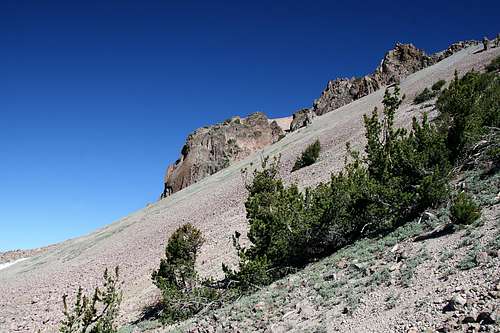
We struck out about 8:00 a.m. Along the ascent up the sometimes rocky, class 1 trail were signs explaining the history of the volcano’s most recent eruption (May 1914). Many of the signs include quotes from the journals of the geologists and rangers who were studying the volcano’s machinations for the ensuing weeks prior to the eruption. It’s very interesting to consider that these brave individuals were often on these very same slopes, surveying ground movement, and smoke and ash-filled skies as eruption was imminent (making it the most recent eruption in North America until Mt. St. Helens).
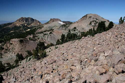
As we ascended, the skies were clear and we had great visibility with views to the south and west. Nearby was Eagle Peak (9222-feet), and in the distance was Lake Almanor. The trail soon wound through a bristlecone pine forest. All along it were remnants of the volcanic eruption. As we made our way even higher along the trail we were treated to a great view of the peak’s permanent ice field on the southeast face of the mountain. Because there were a few other parties hiking the trail, I told Curtis to strike out for the top and that I’d meet him up there (he can hike much faster than me). Meanwhile, I’d stop along the trail, admire the scenery, take quite a few pictures, and talk with the other hiking parties.
|
|
|
One of the more interesting events during the hike was when a hummingbird flew up from below the ridgeline to come about six-inches beak-to-nose with me. He sat there for probably 5-seconds, hovering and considering what I must be, before deciding that there wasn't anything worth sticking his beak into (thank God!). After about two hours total hiking time I reached the top and immediately found Curtis. Now, this wasn’t the true summit of the mountain – it’s just where the trail ended. Since we’d packed a trail lunch, we sat down and enjoyed that.
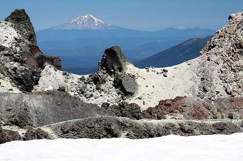
Up there we had a superb view of Mt. Shasta (75-miles away). I took the requisite summit photo, using a telephoto to bring Mt. Shasta even closer into the image (and entertaining the other folks on the summit as I would release the delayed-shutter, then run to go sit by Curtis so I’d be in the picture!).
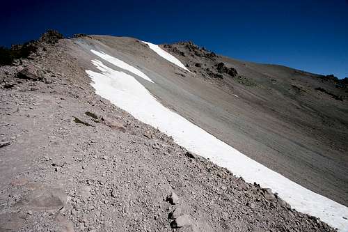
Curtis explained that while waiting for me he’d hiked to the true summit. It was necessary to cross the ice field, then to climb the talus-covered slope for a couple hundred feet.
Curtis headed back down to the bottom, and I struck out for the true summit. The well-trod path through the ice field was about 100-feet long, with walls about 4-feet high on both sides. It was wet and slippery, but easily navigated. I then followed what appeared to be a path on the northwest side of the summit, between the summit and the volcanic caldera. There were great views of the caldera, punctuated by Mt. Shasta in the distance.
As I turned up the steep slope the path petered out. I scrambled up the talus. Immediately below the summit was a woman who’d also made the ascent. I asked her to take my picture (I’d left the camera backpack and tripod where the trail petered out). Right after that I heard the ringing of a phone. It was that woman’s: Her office was calling to see if she was coming into work that day (having forgotten she was on vacation!).
After that I immediately began the descent. By this time there were at least several dozen other parties making the ascent. The hike down was quick, aided by the fact that I’d brought trekking poles to assist me along the rocky trail. It took about 45-minutes to reach the bottom. Upon arrival there I learned that Curtis had managed to establish service for his cell phone (one of the luxuries of being retired is I don’t have one). As we were leaving Yosemite we’d tried to call Bubba Suess to arrange to meet him, but without success. However, Bubba had called and left a message. So I returned his call and learned that he was in Sacramento. Unfortunately, we’d passed there the day before, so wouldn’t be able to meet with him. However, he did give us some advice on places to visit and hike. After that, we stopped at the small shop at the trailhead parking lot, ate a couple hot dogs, then headed for the showers at Manzanita Lake Campground.