Bald Mountain (Skagit County)
This is the OTHER Bald Mountain... Ya, that one...1,600' of elevation gain from gate to summit. 6.5 miles round trip.
Overview
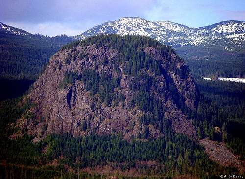
![Bald Mountain]() Bald Mountain
Bald Mountain Standing prominent, proud and towering above lowly clearcuts, this impressive mass of greenstone holds the name Bald Mountain. Interesting enough, sweeping from the valley below onto the exposed rocky side cliffs and up to the summit is home to a majestic, uncut forest. So Bald Mountain might be balding in a few spots, it still holds beautiful, untouched timber.Bald Mountain is a mountain summit located in Skagit County of Washington State. It is located East of Highway 9 and North of Lake Cavanaugh Rd. Bald Mountain climbs to 2,486 feet above sea level and would be agreed that Bald is a peak of small stature but of large prominence. Bald Mountain is located at latitude - longitude coordinates of N 48.366217 and W -122.044867. When you first come around the corner on the summit hike, the prominence of this mountain is very impressive. This mountain deserves attention as a good workout hike, a nice summit approach challenge and amazing views from the summit. Click on this link to view a
Northwest Geology Field Trip .
![Foggy Bald]() Early Morning Fog Around Bald Mountain
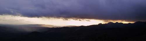
Early Morning Fog Around Bald Mountain![Bald Mountain]() SUMMIT VIEW LOOKING WEST AT SUNSET
SUMMIT VIEW LOOKING WEST AT SUNSETStarting out from the gate on Lake Cavanaugh Rd, (make sure not to block the gate) you will head up a logging road maintained by Weyhauser. The road is in good shape, peaceful and offers the typical things you would see on a logging road. The area serves for a variety of native plants, animals and birds. Its nothing to really get super excited about, but it gets you to where you are going. The road will pass a gravel pit on the left, then you pass spur road on left (ignore). At first your first Y in road head left and after 1.25 miles there will be a gravel pit on your right. Stay along the road and at about 1.5 miles you will take a right and head straight toward Bald Mountain. You will see Bald here and there along the way towering above you with all its 2,486’. You will then cross a bridge and eventually the road will come to a Y. This is at the South base of Bald Mountain. Take a left (west) here and the elevation gain will start to pick up. Continue on the road west which will start doing some goofy switchbacks that take you away, then bring you back and then take you away from Bald Mountain. The goal in following this road is to gain the North side or backside of the mountain. You will start to notice that the North side has lots of trees. At this point on the road always stay to the right because there will be a couple spur roads to the left. Do not take these. At roughly 3 miles you will see a faint boot path on the right side of the road. It is located in a small clearing along an alder lined logging road. You might have to search for it, but it’s not a large area to search.. You will want to find the summit trail because most other possible routes will cliff out.
![Bald Mountain]()
Follow this path that climbs up the North face of Bald Mountain. This standard summit route for Bald Mountain would be at most class 2 climb. Although the route is basically non-technical, the use of hands is necessary throughout the majority of the summit approach. If it wasn’t for the many shrub and root belays, it would probably become more of a challenge due to how steep the timber section is. Also after a hard rain, the approach would become more difficult due to the steep incline on loose rock, mud and mossy boulders. Once you are to the summit it will put you out on a flat slab that overlooks the valley from southeast to southwest. You can see the Puget Sound and San Juan Islands. Because of how flat the summit is, there are areas that are heavy forested and block a 360 degree view. However, you can climb around the summit and find many amazing view points to look in every direction. I would guess that there are at least a dozen or more solid viewpoints on top of mossy boulders. Be careful on the summit, 1,000’ cliffs are typical in all direction. Views toward Big Deer Peak, Whitehorse, Three Fingers, Stimson Hill, Table Mountain and many more can be seen on a clear day.
![Sun Beam]() Rain, Sun and Mountains
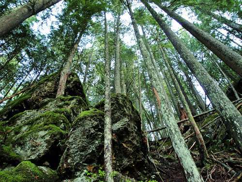
Rain, Sun and Mountains![Looking Up]() LOOKING UP
LOOKING UPGetting There
Head North on Highway 9 toward Big Lake area. Take a right on Lake Cavanaugh Rd and head east. You will follow Lake Cavanaugh Rd for approximately 8.8 miles. The gate will be on your left hand side. It comes up pretty quick, so you might miss it the first time. If you go to the lake, you have gone too far.
![Bald Mountain]() MAP OF ROUTE
MAP OF ROUTERegulations
This area is owned by weyerhaeuser lumber company. Walking in from the gate would be at your own risk.

 23342 Hits
 84.27% Score
 18 Votes
 Bald Mountain
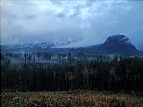 Early Morning Fog Around Bald Mountain
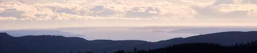 SUMMIT VIEW LOOKING WEST AT SUNSET
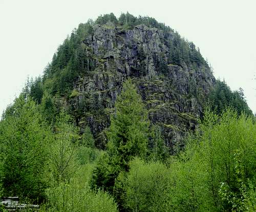
 Rain, Sun and Mountains
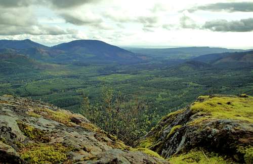
 LOOKING UP
 MAP OF ROUTE
Cascade Scrambler - Jun 9, 2011 10:57 pm - Hasn't voted
Slight correctionJust a slight correction on the approach. Shortly after the gate, you'll come to a gravel pit on your left- keep going. Shortly after this, there will be an abandoned road on your left. Keep going. Very shortly after this, the road actually comes to a "Y" (this isn't mentioned) stay left here, shortly after this, find the pit mentioned in the directions. The rest of the directions are spot on.
gimpilator - Feb 3, 2014 12:12 pm - Voted 10/10
Route UpdateIn February of 2014 the upper route was icy, but a fixed rope over 500 feet long was tied to many trees and made the going easier.
kevinsa - Oct 3, 2015 11:22 pm - Hasn't voted
Permit requiredUnfortunately, the folks at Weyerhaueser got their hands on this one. I don't know the details, but my friend tells me you need a $50 permit to get in this area now.