
-
 16335 Hits
-
 79.78% Score
-
 11 Votes
|
|
Mountain/Rock |
|---|---|
|
|
48.57833°N / 120.88842°W |
|
|
Hiking, Mountaineering, Scrambling |
|
|
Spring, Summer, Fall, Winter |
|
|
8690 ft / 2649 m |
|
|
Overview
Katsuk Peak is located on Ragged Ridge just 0.4 miles west of Mesahchie Peak. It is one of four Bulger peaks on the ridge and offers fantastic views of Mount Logan and Goode. Few people make the trip to climb this peak due to its difficult position on the ridge and there are only a couple feasible ways to reach it. Not surprisingly, nearby Kimtah and Cosho Peaks are even harder to get to making these peaks some of the hardest non-technical Bulger peaks on the list. No technical rock climbing or serious glacier travel is required for any of these peaks but the terrain is very rough. Come prepared for lots of talus, hours of sidehill traversing, sustained rock scrambling and an occasional snowfield (depending on season) if you plan to attempt Katsuk Peak.
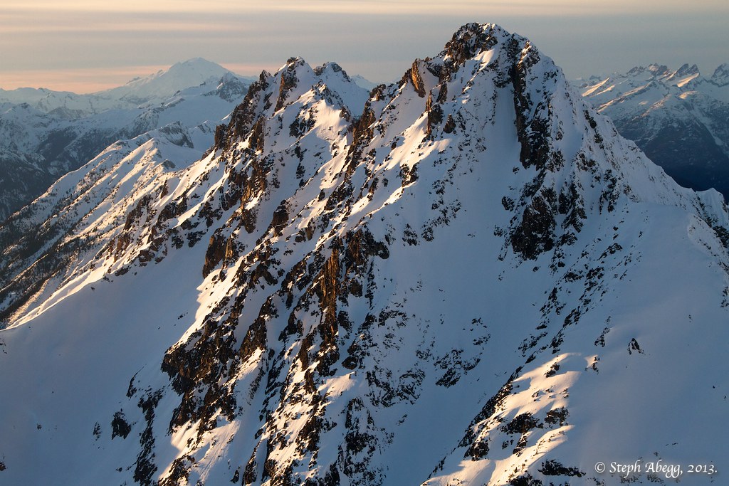
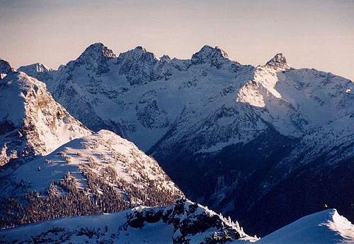
Katsuk (left) in winter from a plane - By Steph Abegg
Getting There - Easy Pass TH
Anyone looking to climb any of the Ragged Ridge Peaks should start at the Easy Pass Trailhead off High 20. This signed trailhead is located on the west side of the highway about 30 miles east of Newhalem.
From Seattle - Take I-5 north to exit 210 and follow WA 530 east to Darrington. Continue as it turns north and meets Highway 20 in Rockport. Turn right (east) onto Highway 20 and continue 8 miles to Marblemount where you can get a free backcountry permit at the ranger office located 1 mile off the highway on Ranger Station Road. Since the peaks along Ragged Ridge lie within the North Cascades National Park this is required. Continue along Highway 20 past Newhalem and look for the sign for the Easy Pass Trailhead roughly 30 miles past Newhalem.
From Winthrop - Drive west on Highway 20 41 miles to the Easy Pass Trailhead on the left.
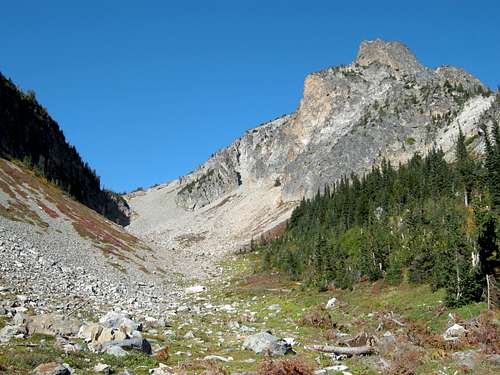
Looking up to Easy Pass with "New Morning Peak" on the right
Approach
Begin on the trail as it quickly crosses Granite Creek on a very well-built log bridge, and then start climbing. The trail to Easy Pass is 3.6 miles long and gains 2,700 feet, but the trail is in excellent condition. It takes about 2 hours to reach the 6,550 foot pass which is a beautiful place with many larch trees and grassy meadows. Your goal is to get to the small basin at about 6,600 feet just south of Mesahchie Peak with a small knob next to it. I will call this the Ragged Ridge Camp. From Easy Pass it can be seen a mile and a half due west and snow typically lingers in this basin into August.
Begin contouring northwest at the 6,600 to 6,700 foot level along the south face of Kitling Peak. There is a series of small rocky ribs and gullies a short ways from the pass that you can traverse above on grassy terrain around 6,800 feet. After roughly an hour of sidehill traversing you will reach a large basin just south of the Mesahchie Col (the saddle between Mesahchie and Kitling Peaks). Traverse across this basin on softer ground and continue on a slight ascending traverse following small marmot trails and rocky ledges through the ribs and gullies. A nice grassy ledge follows the 6,800 foot contour. Just before you reach a larger stream with a small waterfall, descend steeply for 150 feet and cross the stream and continue past a couple more small ridges at which point you can descend 50 feet or so into the basin where you can set camp. There is an excellent water source draining this basin and depending on how late in the season you go, most of the flat spots may still be snow covered. Our tent was on a light angle since we didn't want to camp on snow.
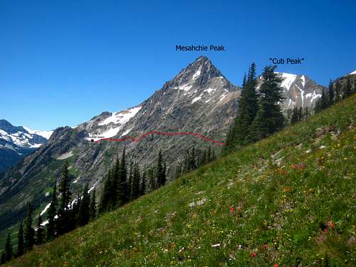 Route to Ragged Ridge Camp | 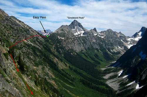 Route to Ragged Ridge Camp |
South Gully Route - Class 4
From Ragged Ridge Camp, ascend 200 feet to the small saddle immediately west of the 6,870 foot knob directly above camp. From here the going gets tougher. Ascend northwest to the 7,400 foot bench on the prominent ridge descending from the Katsuk Peaks' western summit. This 600 foot ascent involves tedious scree and a little 4th class scrambling for the final 100 feet to the bench. There are many ways to finish the final section whether up one of the gullies or ribs but I thought this was the crux of the climb.
From this bench you command an excellent view of Katsuk Peak and the remainder of the route. Mesahchie Peak also dominates the view to the right. This is a good place to study the route on Katsuk as well. Locate the leftward trending gully high on the peak that ends just below a mushroom looking summit block. This is the route however the lower half of the gully is hidden behind a buttress from this point. Following the gully down you will notice a small waterfall (if snow is still present) marking the place you must traverse to.
Hike a short distance up the broad ridge then veer left and make an ascending traverse below the cliffs to this small waterfall at 7,760 feet. Here the scrambling begins. Bypass the waterfall by heading up the left (west) side of the stream on fairly loose rock covered with kitty litter scree. I thought this was one of the more dangerous parts of the route but with care it was no more than Class 3. After 50 feet or so the rock transitions to granite and the scrambling becomes much more enjoyable. Continue climbing up either side of the stream to 8,100 feet where the gully widens and forks. You want the left fork.
Continue 500 more feet either up the gully proper or on the Class 3 rib directly to its left. Steep snow will persist in this upper gully well into August so if you wish to stay on rock, the rib is an excellent scramble. The gully ends right at the base of the summit block which can be climbed on its west side by a series of blocks with Class 3 scrambling. Extreme care is needed climbing the final 50 feet up the summit block as there are many loose rocks with huge exposure down the north face. The summit register we found was placed in 2004 in a plastic pill container. All of the original John Roper registers placed on the Ragged Ridge peaks are gone.
* Note that in early season (before July) this entire gully will be filled with snow and will require steep snow climbing. The snow will exceed 45 degrees in places requiring an ice axe and crampons with good snow climbing experience. By August in normal years, any remaining steep snow should be avoidable.
** Also note that the USGS Mount Logan quadrangle labels the western sub-summit of Katsuk Peak with an elevation of 8,425 feet when the true summit lies just to the east where an 8,680 foot contour is visible. The accepted elevation for Katsuk is 8,690 feet.
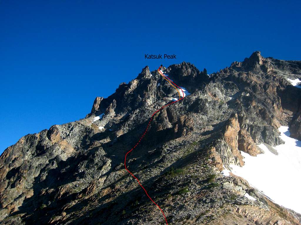
Katsuk Peak Route Diagram
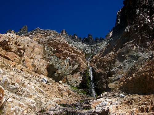 The waterfall at the base of the ascent gully 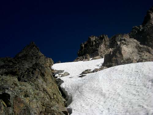 Upper part of the gully with the rib option at left | 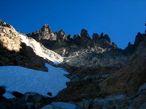 Looking up the lower part of the gully 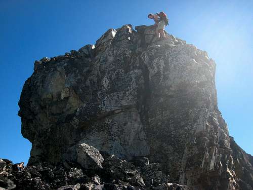 Josh descending the summit block |
Map
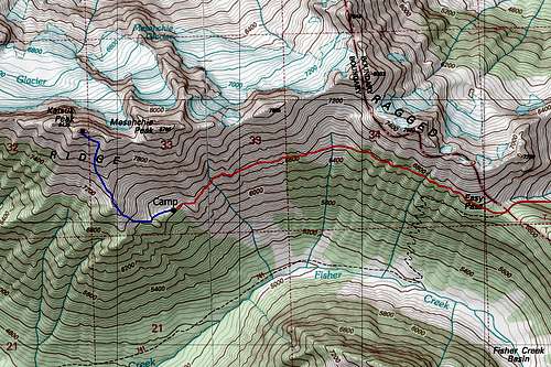
Katsuk Peak Map
When to Climb
Katsuk Peak can be climbed any time of year however virtually no one climbs it when Highway 20 is closed for the winter. So it's best to climb when the road is open, typically between late April and late October or early November. I am sure the traverse to camp and the scramble up the gully would be very tedious under a fresh dusting of snow or if wet from recent rain. Consider going in good weather when everything is dry.Camping/Red Tape
This peak lies within the North Cascades National Park therefore a free backcountry camping permit is required. Leave no trace of your visit and camp on durable surfaces. The best place to camp is in the 6,600 foot basin south of Mesahchie.
Ragged Ridge from Ruby Mountain