
-
 8207 Hits
-
 81.69% Score
-
 14 Votes
|
|
Canyon |
|---|---|
|
|
43.58150°N / 103.4837°W |
|
|
Hiking, Scrambling, Canyoneering |
|
|
Overview
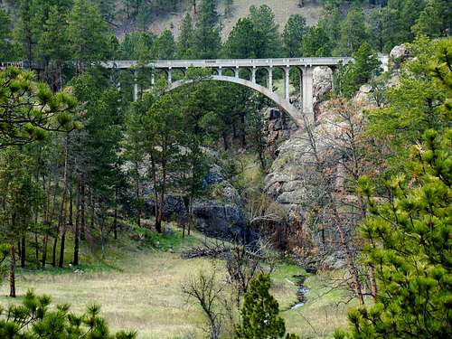
The famous single-lane "High Bridge" over Beaver Creek Canyon
Perhaps the most significant canyon in Wind Cave National Park is Beaver Creek Canyon. The park currently has about 2.7 miles of trails in the canyon open to the public, plus 2 miles of canyon floor that can be explored off-trail. There is more of the canyon to be explored beyond these sections, but access is not yet allowed into the newly-acquired portion of the canyon, which has grown the park to nearly 34,000 acres. Hiking through Beaver Creek Canyon provides great wildlife viewing opportunities and lots of great photo ops. Several side canyons, such as Curley Canyon, Reaves Gulch and Limestone Canyon provide additional opportunities for off-trail canyon exploring.
The Beaver Creek watershed is mostly confined to Custer County. A significant portion of Beaver Creek is simply a mountain stream that flows through broad valleys in the Black Hills. This is especially true upstream from Beaver Creek Canyon. However, about 8 miles of the creek passes through Wind Cave National Park in a canyon, losing all its stream flow just above where another broad valley begins. The final 3 miles of the creek’s flow in the Black Hills is through another broad canyon. Beaver Creek’s watershed is about 20 miles in length from the headwaters near Sanator to where the stream leaves the Black Hills at Buffalo Gap, dropping 2,000 feet in altitude. Beaver Creek Canyon drops about 700 feet from the park’s western boundary to where the upper canyon ends at the old Sanson Ranch. A majority of Wind Cave National Park drains into Beaver Creek. Stream flow in Beaver Creek is significant in places, yet toward the end of the upper canyon, the stream flow goes back underground. It re-surfaces further downstream in the lower canyon, just before the Trout Haven Ranch that is located along 7-11 Road.

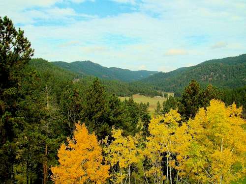
Autumn Tranquility
The most common form of large wildlife generally seen in Beaver Creek Canyon is bison and deer. However, Wind Cave National Park also has a good-sized elk population, plus many pronghorn antelope, often seen in various locations in the park, including the canyon. Coyotes are seen occasionally, and there are rare sightings of mountain lions. Prairie dogs are very common in the park and the canyon. Rattlesnake populations tend to be larger near areas with large concentrations of prairie dogs, so if you are near a prairie dog town, be alert. Bird watchers come to the park in significant numbers, due to the large variety of species that are found there. The limestone and sandstone canyon walls, along with the abundant pine, spruce, aspen, ash, oak and cottonwood trees provide great shelter and nesting opportunities for many birds.
Getting There
Beaver Creek Canyon is usually accessed from Highway 385, which runs through the western half of Wind Cave National Park. The Centennial Trailhead provides the best access point and is approximately 13 miles north of Hot Springs, along Highway 87.
Route Options
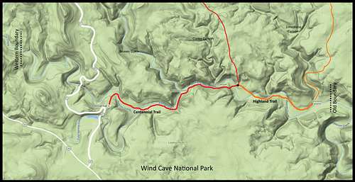 Beaver Creek Canyon Map for Wind Cave National Park
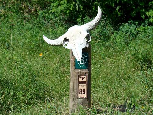
Centennial Trail Marker
Currently, the only option to explore the canyon by trail begins at the Centennial Trailhead. This is the southern terminus of the 111-mile Centennial Trail through the Black Hills. The Centennial Trail follows Beaver Creek downstream for about 1.7 miles, before leaving the canyon and veering to the north at the junction with the Highland Trail. From that point, the Highland Trail continues along Beaver Creek for another mile or so, before it veers north into Limestone Canyon. The former park boundary is less than a quarter-mile downstream from here, and though the canyon land beyond that is now part of Wind Cave National Park, it is currently off-limits for exploration. Park officials are hoping to open this up to the public at some point in the future. Upstream from the Centennial Trailhead, there is no trail along Beaver Creek, requiring off-trail hiking through the 2 miles of canyon floor to the western park boundary.
NOTE: Hikers and canyon explorers need to be aware of the dangers posed by the bison residing in the park. It is very important to keep a great distance from these unpredictable animals. They can move much more quickly than humans, and a person is no match for a bison that can weigh up to 2,000 pounds. There is often little shelter in the bottom of the canyon. Bison with calves as well as bison during mating season (May-August) are especially dangerous. If you must have a “close-up” photo, please do it with a long telephoto or zoom lens.
Red Tape

Wind Cave Bison

Centennial Trailhead
Red tape will vary depending on what part of the Beaver Creek Canyon you wish to explore. You can hike the public areas year-around without any red tape. The exception, of course, would be the new addition (old Sanson Ranch) to Wind Cave National Park. Lower Beaver Creek Canyon is all on private land, so unless you can get landowner permission, you can only sight-see from 7-11 Road. Fossils and unusual rocks are abundant in the area and removal of any fossils and rocks from public lands is illegal. Starting campfires in non-designated areas will get you into trouble, as will discharging any firearms. For more specific information, you can contact the park headquarters:
Wind Cave National Park Phone: (605) 745-4600
When to Explore

Wildflowers in Canyon
The canyon can be explored year-around, weather permitting. Because of flash flood potential, you will want to stay up-to-date on the weather. You can find out more by clicking here:
Wind Cave National Park Weather
Hunting is not allowed in Wind Cave National Park, so this should not be an issue during any part of the year. However, hunting is allowed on the national forest and private lands elsewhere along Beaver Creek. You can learn more about the hunting seasons by clicking on this link:
Black Hills Hunting Seasons
Camping & Lodging
Beaver Creek Valley
Camping in the National Forest areas near the canyon are regulated by Black Hills National Forest Camping Regulations. Wind Cave National Park does not permit camping in the park, except at their Elk Mountain Campground near Wind Cave. Visitors may also camp at the nearby Cold Brook Reservoir’s campground. For more information, please click on the desired link below:
Wind Cave National Park Camping
Black Hills National Forest Camping
Cold Brook Reservoir Camping
Hot Springs Camping & Lodging
Maps

Centennial Trail

Beaver Creek Canyon
Wind Cave National Park posts maps for their park trails. You can view their trails page and interactive map at this link:
Wind Cave National Park Map
Good maps for the area include the Black Hills National Forest map and the Black Hills South map published by National Geographic. Both maps can usually be purchased at area forest service offices. When you are there, you can also get a free Black Hills Motor Vehicle Use Map that will guide you to all currently accessible forest service roads.