-
 14760 Hits
-
 80.49% Score
-
 12 Votes
|
|
Canyon |
|---|---|
|
|
43.73840°N / 103.8453°W |
|
|
Hiking, Scrambling |
|
|
Overview
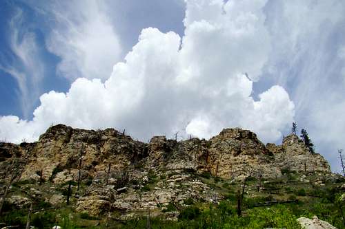
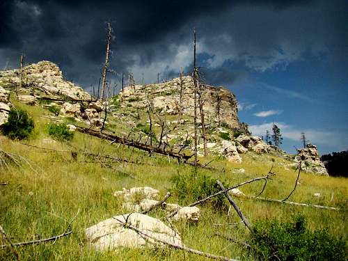 Hell Canyon Storm
Hikers in the Black Hills will find a great opportunity in Custer County to explore one of the hills' best canyon systems. While many of the Black Hills' canyons are difficult to access, due to lack of roads or for private property concerns, Hell Canyon offers visitors a chance to explore much of it's basin. Jewel Cave National Monument is probably the major reason why Hell Canyon is more accessible than most other Black Hills canyons. While Jewel Cave National Monument is located almost entirely in the Hell Canyon basin, it only currently occupies about 2 square miles of the almost 82 square miles in the Hell Canyon basin. As one of the world’s longest cave systems, with over 170 miles mapped so far, cave experts believe this cave has the potential to become the world’s largest someday . But Jewel Cave was not always such a major factor in this area years ago.
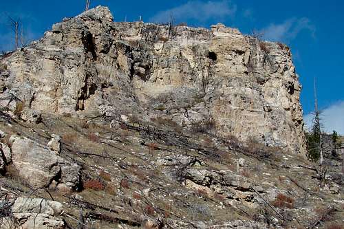
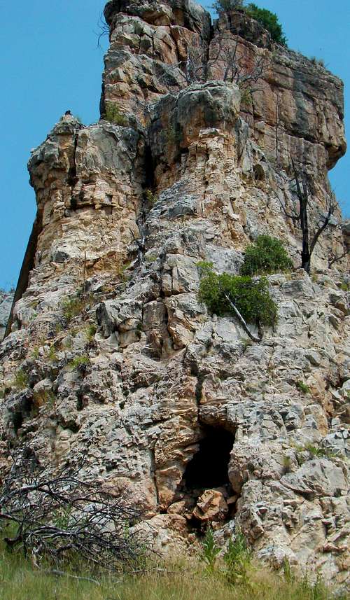 Hell Canyon Tower
Ranchers settled this region in the late 1800’s, following the first influx of gold-seekers to the Black Hills. In addition to ranching, the mining and the timber industries did reasonably well. In fact, timber was an important consideration when the Signal Hill fire lookout tower was built several miles north of Jewel Cave. Both scientific and tourism interests led to the establishment of a Civilian Conservation Corps camp in Hell Canyon in 1935. For four years, workmen did much of the work that provided the foundation for what is now Jewel Cave National Monument. Hell Canyon’s basin actually starts in the extreme southern part of Pennington County at nearly 7,000 feet, just west of Bear Mountain. The Hell Canyon watershed drains into Pass Creek, 3,000 feet lower, in southern Custer County. Hell Canyon is joined by West Hell Canyon less than a mile north of Highway 16. At the south end of Jewel Cave National Monument, Hell Canyon is joined by Lithograph Canyon.
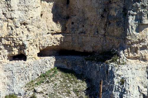
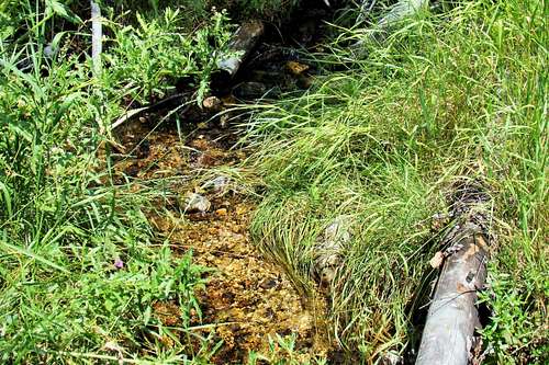
The Gillette Canyon watershed lies to the north of Hell Canyon, while Tee Pee Canyon and Schenk Canyon are to the west of Hell Canyon. This rugged canyon system is characterized by sedimentary outcroppings of sandstone, dolomite, gypsum, some shale and limestone – both Pahasappa and Englewood. There is no consistent water flow in the various streams in the canyon and its branches. However, there are some springs. Few produce much water, though there is one that creates a nice brook in West Hell Canyon. However, that water all disappears underground again. There is a big fault north of Jewel Cave, and some geologists believe that fault has something to do with the weak springs in the area, and a lack of good soil downstream from the fault.
 Good Lookout for Mountain Lions
Wildlife commonly seen in the area includes deer, elk, bighorn sheep, pronghorns, coyotes, bobcats, weasels, marmots, porcupines, rabbits, wild turkeys and eagles. Mountain lions and foxes are seen on rare occasions. What remains of forests in the Hell Canyon basin, are mostly comprised of ponderosa pine, birch, aspen, box elder and willows. Mountain mahogany shrubs are common, as are cactus, yucca and sagebrush in the lower elevations. Up to 90% of the forests in this region were burned by the terrible Jasper Fire of 2000, when about 130 square miles were burned.
Getting There
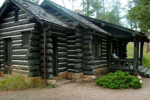
 Jewel Cave Entrance
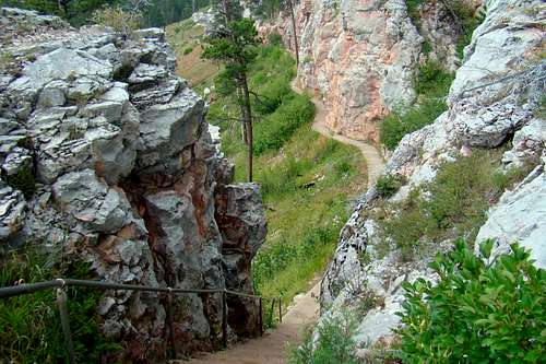 Canyons Trail Near Old Caves
Highway 16 is the only major roadway through the Hell Canyon basin. From Custer, South Dakota, it’s about 13 miles to Jewel Cave National Monument. From Newcastle, Wyoming, it is about 25 miles to Jewel Cave. It probably would not hurt to call the park office before you travel there to see if there will be any road construction delays. It is hard to do detours in that terrain, and past projects caused considerable delays. You can reach the park office at:
(605) 673-8300.
Routes For Exploration
There are currently only two designated hiking trails in Hell Canyon. However, there are other exploration possibilities permissible in the canyon. This section will cover three publicly accessible routes, plus options.
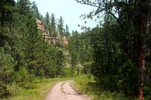
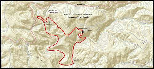 Canyons Trail Route
The Canyons Trail: This trail is the one most frequently used for hiking into Hell Canyon, since it lies entirely within Jewel Cave National Monument. The trailhead is at the Jewel Cave Visitors Center. There is no admission fee to enter the monument, nor are there parking fees. The only fees are for cave tours. Jewel Cave National Monument lists this trail at 3.5 miles for the loop. There is not a great amount of altitude variation on the loop, between the highpoint and low point, with the difference being a little over 300 feet. The trail is named for the two canyons used in the trail loop – Hell Canyon and Lithograph Canyon. The Canyons Trail could be divided into three basic segments. The first segment runs from the Visitors Center to the picnic area near the old cave entrance. It is about one mile in length. For 3 ½ months of each year, the picnic area is open and can also be used as a trailhead, since the old cave entrance there is where the trail drops down into the second segment.
 Lithograph Canyon
The second segment follows the floor of Hell Canyon, and is about 1.5 miles long. It passes by occasional groves of trees, rocky canyon walls and barren areas. This area is where the forest fire devastation is still most visible. The stream on the canyon floor is normally dry. At the mouth of Lithograph Canyon, where it transitions to the third part, the trail begins a more northerly direction. The Lithograph Canyon section of the Canyons Trail is close to one mile long. Depending on your choice of direction on the Canyons Trail, it can be the end or beginning of your loop from the Visitors Center. The Lithograph Canyon portion of the trail is also the shadiest section, with many trees and beautiful rock walls along the way. Click here to view the Canyons Trail Photo Album
 Hell Canyon Trail Routes
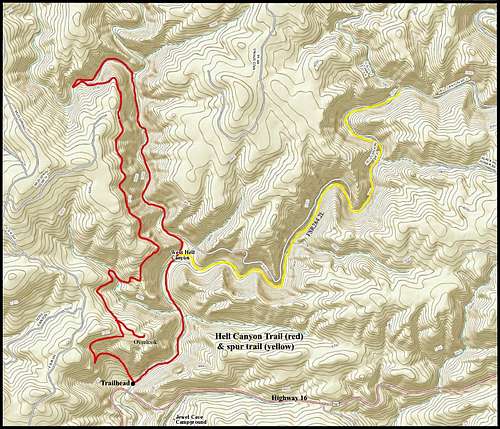
Hell Canyon Trail: This trail is usually considered the most scenic, as it traverses the deepest and narrowest portions of Hell Canyon and West Hell Canyon. The National Forest Service, which administers this trail, lists it as a 5.3 mile loop. The altitude range for much of this route is roughly 5300 feet at the canyon floor and 5800 feet at the trail’s highpoint on the canyon rim. The trailhead is about 1 mile west of the main entrance to Jewel Cave National Monument. Trail brochures assume you will hike this loop in a clockwise manner, but there is no requirement to do so. Assuming you do, the first ½ mile is spent ascending the side of the canyon. The next couple miles are fairly level, much of which traverses a bench above the canyon. There is also a ½ mile spur trail that leads to an overlook along the way, if you are interested. Near the northern end of the loop, the trail drops 300 feet or so, back down to the canyon floor. Once on the canyon floor, the trail begins curving back toward a more southerly direction. There is a large amount of vegetation on the canyon floor, and the forest service advises ticks are in abundance here, so take whatever precautions you prefer. About ¾ of a mile from the trailhead, you will pass the junction of Hell Canyon and West Hell Canyon (the upper half of this trail loop is in West Hell Canyon).
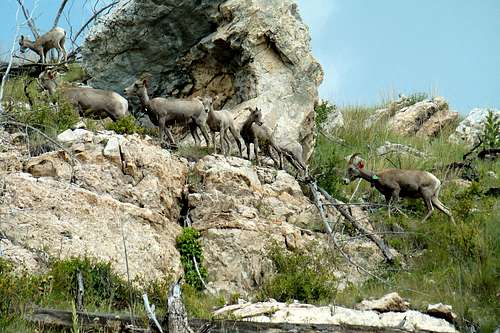 Small herd of bighorn sheep
At that junction, you will find a faint old 2-track road that goes up Hell Canyon. At 2.3 miles up that road, there is another junction with a side canyon on Short Fork Creek. This 2.3 mile section of Hell Canyon is probably the most scenic section of Hell Canyon that is not officially designated as a trail. This old 2-track road (yellow on the route map) shows up on older maps as FSR284.2L. On the newer forest service motor vehicle use maps, this section has been left out. If you have the time to hike this as an “out-and-back” in addition to the loop, you may extend your canyon adventure. Along the last ¾ mile of the loop, you will notice the flowing stream has disappeared. If you also noticed an asphalt section on the trail, it is speculated that it was somehow part of the work done by the CCC Camp in Hell Canyon from 1935-1939. Click here to view the Hell Canyon Trail Photo Album
National Forest Service Information for the Hell Canyon Trail
Note: Exploring further up into the Hell Canyon system from the Hell Canyon Trail is possible, since most of it is on public lands. But, it is less scenic because the canyons pretty much turn into dry creek valleys, and the forests are almost non-existent for a number of miles. The one exception is the Hell Canyon section from FSR681 to FSR284.2A. The canyon there is shallower and has less vegetation, but would still make a good hike.
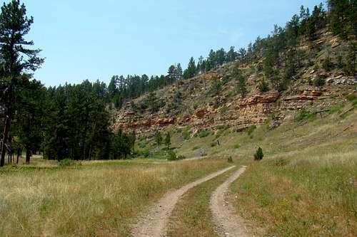
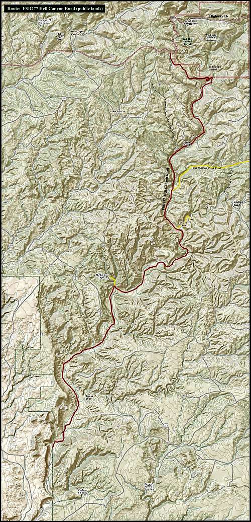 Hell Canyon Road Route
Hell Canyon Road (FSR277): Most people who visit this lower part of Hell Canyon, usually do so by motorized vehicle. Due to minimal traffic on this road, hiking this road is another reasonable way to see the lower portions of Hell Canyon. FSR277, Hell Canyon Road, is about 2 miles west of the main entrance to Jewel Cave National Monument. It is not well-marked, so make sure you are watching for that turn-off. From Highway 16, it is about 1.3 miles to the canyon floor. There is a junction there and you will see to the left a closed gate at the boundary of Jewel Cave National Monument. Of course this means go back or go down the canyon. Your public lands exploring options will last for the next 12 miles down the canyon until you start traveling though all private property. And by the time you get to that private property area, the canyon is flattening out, since it is not far from there to where the Hell Canyon watershed merges with Pass Creek. The Hell Canyon basin is almost entirely on public lands. However, there are a few areas of private land in the bottom of the canyon, where you will find some ranches. Most of them run some cattle on the public lands in the canyon, so wherever you choose to explore off of Hell Canyon Road, please make sure you watch for “No Trespassing” signs and close cattle gates behind you if you find any. A couple noteworthy side routes you will encounter, include FSR 274 Pass Creek Road (a branch of the main Pass Creek Road – FSR273), FSR 694 Water Draw Spring and FSR277.2A McKenna Spring. You may see other faint old roads/trails along the way, but these are the main ones.
 Hell Canyon Road
The Pass Creek side route takes you about 4 miles through some pretty heavily forested areas before you come to the main Pass Creek Road (FSR273). When you see the road, you will realize this does not get much traffic, and if you decide to hike this route you will most likely have the whole area to yourself. It is only about ½ mile to Water Draw Spring from FSR277, and there is a loop road/trail that goes to the south past it. Despite 2014 being a very rainy year in the Black Hills, there was not much water here when I visited it. McKenna Spring is probably ½ mile or less off Hell Canyon Road, in a wooded area. Though McKenna Spring is on public land, this part of the canyon to the east of the road is all private property – an area to be aware of trespassing concerns. All this would be a huge expedition if one were to hike the whole length of Hell Canyon Road, plus side roads & trails. Studying good maps and bringing the proper gear and plenty of water before venturing into this part of Hell Canyon would be definitely advisable. Click here to view the Hell Canyon Road Photo Album
When To Explore
 Approaching Storm
The canyon is pretty much open to the public year around. Even though Jewel Cave reduces their hours of operation during the winter months, the Canyons Trail is still open. Hunting seasons in the Black Hills affects the rest of the Hell Canyon basin, so you might want to check that out before you schedule an expedition in late fall or in the spring. You can find out more about South Dakota hunting seasons by checking out their website here:
South Dakota Hunting Seasons Information
Weather will be the largest concern for most canyon explorers. Not only can blizzards and summer lightning be deadly, but finding yourself in the bottom of a deep canyon during a flash flood can also be life-threatening. To learn more about the latest weather conditions and forecasts, click here:
Jewel Cave – Hell Canyon Weather
Red Tape
 Good Hiking Area
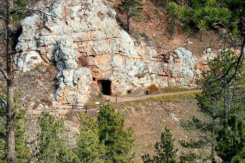 Old Entrance to Jewel Cave
Most of the Hell Canyon basin is on public lands and is open for public use year-around. And since most of the Hell Canyon basin is managed by the National Forest Service, it is important you know their regulations for anything more than a casual hike. You can learn more about the National Forest regulations, including back country camping, by clicking on this link:
Black Hills National Forest Regulations
Jewel Cave National Monument has its own regulations, which can be accessed here:
Jewel Cave National Monument Regulations
The national monument is open year-round with the exception of Thanksgiving, Christmas and New Year’s Day.
Maps
 Great Habitat for Birds
Two helpful maps for the area include the National Geographic Black Hills South map, as well as the Motor Vehicle Use Map for the Black Hills National Forest. Both maps are available at the National Forest Office in Custer:
U.S. Forest Service Black Hills National Forest Supervisor’s Office
1019 N. 5th
Street Custer, SD 57730
(605) 673-9200
Camping
 Hell Canyon Oasis
The National Forest Service has many campgrounds in the Black Hills. Their website provides a list, which can be accessed by clicking on this link:
Black Hills National Forest Camping
The nearest campground is the Comanche Park Campground, located about 7 miles east, near the junction of Harry Mills Road & Highway 16. You can access that information at this link:
The nearby town of Custer offers a large selection of camping and lodging facilities. The Custer Chamber of Commerce maintains an up-to-date list of area facilities that you can access by clicking here:
Custer State Park, about 25 miles east, also offers a wide variety of camping & lodging options. You can access their website by clicking here:
Custer State Park Camping & Lodging
Resource Information
11149 US Highway 16
Building B12
Custer, SD 57730
(605) 673-8300
Jewel Cave National Monument Hiking Trails Information
Hell Canyon Trail Video on YouTube
Report: The Jasper Fire Thirteen Years Later