
-
 41536 Hits
-
 97.08% Score
-
 65 Votes
|
|
Area/Range |
|---|---|
|
|
43.73935°N / 103.43079°W |
|
|
Hiking, Sport Climbing, Mixed, Scrambling |
|
|
Spring, Summer, Fall, Winter |
|
|
7242 ft / 2207 m |
|
|
Overview
Conveniently located just south of I-90 in western South Dakota, the Black Hills are the state’s major tourist destination. Incredibly, the AAA guide to South Dakota gives this region significantly more pages than the rest of the state put together. The Black Hills also extend into the Bear Lodge Mountains of Wyoming, and conventionally include Devil’s Tower.
Tourists come for Mount Rushmore, Crazy Horse, and dozens of roadside attractions that include miniature golf courses, gambling, museums, and zoos. Other activities include the Old West town of Deadwood, urban attractions in Rapid City, and the Sturgis motorcycle rally. The Crazy Horse Memorial memorializes the famous Indian leader - - in part as a response to Mount Rushmore (see “History and Politics” below).
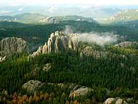
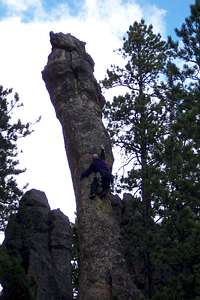
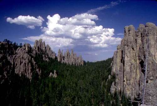
Needles summit by Ice Man Jerry Van
In addition to climbing Devils Tower, SPers are most likely to visit the area to hike up Harney Peak, South Dakota’s High Point. South Dakota claims that this is the highest point between the Rockies and the Pyrenees, but this claim requires excluding points farther north (Canada’s Arctic islands) and south (South America). Nonetheless, the observation tower at the summit provides great views of the Black Hills and the surrounding prairies.
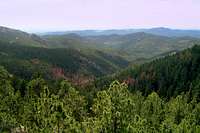
Because they rise from the prairie, the Black Hills are more impressive-looking than you might think, given their relatively low altitude. The biotic communities are dominated by ponderosa pine forest intermixed with prairie and savannah. It is generally wetter to the north than to the south, leading to variation in the plant communities.
History and Politics

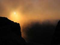
Sunrise from Harney by predator24
The Lakota (Teton Sioux) people call the Black Hills the Paha Sapa, and view the area as the center of the world. However, the Sioux were relatively recent residents of the area, having moved out of Minnesota in advance of white settlement, pushing the Cheyenne westwards.
The 1868 Treaty of Fort Laramie granted Paha Sapa to the Lakota forever. In violation of this treaty, gold miners entered the Black Hills in 1872, and the US government did little or nothing to stop them. The Indians’ refusal to sell the Black Hills helped set in motion the chain of events that led to the Battle of the Little Bighorn in 1876.
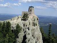
Harney's fire lookout
After years of dispute, the US offered the Lakota Nation $17.5 million for the Black Hills in 1977, representing the alleged value of land in 1877. The Lakota rejected this offer, and continued to press their claims in court. This ultimately led to a Supreme Court decision in 1980 that confirmed that the land had been taken illegally. The Court set a price on the land equal to the initial offer price, plus interest. The Lakota continue to refuse the money, which still earns interest in an escrow account and is now worth over $1 billion. The Nation demands the land, not the money.
The Lakota population of the nearby Pine Ridge Indian Reservation has been estimated between 15,000 and 30,000, and is probably toward the higher end of this range. It is the poorest part of the United States, which makes their principled refusal to accept money for the Paha Sapa all the more remarkable.
In the meantime, some of the Lakota (Sioux) tribes have decided to argue for more extensive wilderness designations in the Black Hills, especially in the Black Hills National Forest. They would like these wilderness designations to exclude new trail building. Some national environmental, including the Sierra Club and Wilderness Society, support these tribal efforts to restrict future development in the Black Hills. This is probably an argument that most SPers would agree with.
Public Lands
The Black Hills include many different types of public lands, both state and federal. The largest by far is the Black Hills National Forest, but several national and state parks attract more visitors.
Bear Butte (Mato Paha) State Park
Bear Butte State Park. Bear Butte (Mato Paha) is sacred to local tribes, and the site of various religious ceremonies. The park has some hiking and riding opportunities.
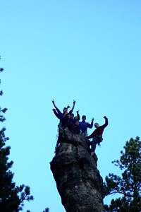
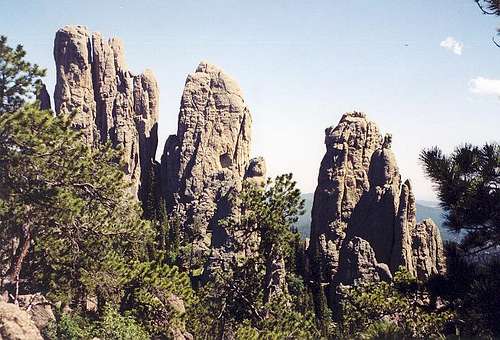
Ice Man Jerry Van climbing in the Needles
Black Elk Wilderness
The Black Elk Wilderness includes the highpoint of Harney Peak. It lies in the heart of the Black Hills, surrounded by the Norbeck Wildlife Preserve. It is named for a Lakota holy man, immortalized in the book "Black Elk Speaks."
Black Hills National Forest
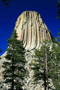
Devils Tower
Black Hills National Forest (BHNF) is by far the largest landholder in the region. It is managed for multiple use, including mining, logging, cattle grazing, and summer homes. It has over 450 miles of trails as well as outstanding rock climbing opportunities. See Dow William’s page on the Needles for climbing.
There are two long trails that make extensive use of BHNF, the Centennial Trail and the George Mickelson Trail. There's red tape associated with both (see below). In summer some of the water sources are not dependable and you will want to plan ahead.

Devils Tower National Monument
Devils Tower National Monument has its own page on SP by bigwally. The Tower is a famous climbing destination.
The Tower is also sacred to several area tribes, most of which ask people not to climb it. The NPS straddles this issue, as so many others, by asking people not to climb in June, the month of the summer solstice.
Fort Meade Recreation Area
Fort Meade Recreation Area, managed by the Bureau of Land Management. FMRA is located in the eastern foothills of the Black Hills, and was established as a cavalry fort in 1878. It includes eleven miles of the Centennial Trail, but its focus lies on motorcycle, bike, horse and other non-foot recreational uses as well as camping. Aside from the Centennial Trail, there isn't much for SPers.
Rappelling, by George!
Custer State Park
Custer State Park. After BHNF, the largest landowner is the state of South Dakota. Given the Lakota claim to the hills, it’s remarkable that the park is named after General George Custer, but there it is.
Jewel Cave National Monument
Jewel Cave National Monument protects the world’s second-longest cave. Its surface is much less interesting than Wind Cave NP, though there are some short trails (see below).
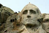
Mount Rushmore National Memorial
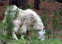
Mountain Goat

View on the Centennial Trail
Mount Rushmore National Memorial holds the famous sculpture of four presidents. Blasted and carved from the rock over 1927-1941, Mount Rushmore attracts more than two million visitors a year. Those visitors mostly account for the extensive traffic throughout the Black Hills area.
There are some short paved walks in the park, but nothing of any interest to backcountry users. Not surprisingly, there is no rock climbing allowed on the face of the presidents’ faces.

Crazy Horse, model and mountain
Wind Cave National Park
Wind Cave National Park (WCNP). As its name suggests, the original purpose of this park was to protect one of the world’s longest caves. Over time, the surface land has become just as important, a preserved area of mixed-grass prairie. Because the park preserves a place where the short-grass prairie of the western plains meets the long-grass prairie farther east, it is an area of mixing and change, with an abundance of wildflowers and other plant species.
In 1911, the Park began one of the earliest reintroduced bison herds, with support from the American Bison Society. It also has a prairie dog complex as well as more common charismatic megafauna such as elk (wapiti), pronghorn, mule deer, and coyotes. Parts of the park are quite lovely, and worth an above-ground visit.
Private Lands
 Centennial Trail View
The Black Hills are also full of private lands. Some of these, like the towns and ranches scattered about, are pretty obvious. Others are interspersed in the national forest lands in the usual checkerboard pattern.
The two Trails Illustrated maps show these lands clearly.
The most unusual private lands are probably those owned by the Crazy Horse Foundation, which is currently dynamiting a mountain to make a sculpture of Crazy Horse. This is essentially a rebuttal to Mount Rushmore, begun in 1944.
Fees and Backcountry Red Tape

Bear Butte State Park charges an entrance fee of $5/day per vehicle.
Black Hills NF has no entrance fee but some trailheads require a $5 parking fee per day. “Dispersed camping” in the backcountry is free, and allowed for up to 14 days in any 60-day period. Camping is limited to designated areas around developed reservoirs and campgrounds. Campfires are legal in Wyoming portions of the National Forest but prohibited in the South Dakota portions.
As a multiple-use area, many activities are allowed that affect the backcountry experience, including biking, horseback riding, and hunting. Small-scale collecting of surface rocks, but not fossils, is also allowed, as is recreational gold panning in some places. More information about BHNF rules can be found here.
Centennial Trail has no fee per se, but note the rules of the lands you cross. Camping is allowed everywhere along the trail with a free backcountry permit, except in the Custer State Park (see below).

Custer SP charges $5/person or $12/vehicle in season. The park allows camping only in developed areas, except in French Creek Natural Area (FCNA). All these campsites require payment of a fee. In the FCNA, camping is free. There are lots more rules here.
The George S. Mickelson Trail requires a permit costing $2/person/day or a $10 annual pass.
Access to the surface of Jewel Cave and Wind Cave is free, but there are fees for cave tours and other caving.
Wind Cave NP requires that everyone obtain a (free) permit for backcountry camping, to assist the NPS with planning. The NPS prohibits pets, bicycles, motorized equipment, firearms, and hunting in the backcountry. Campsites must be a quarter-mile from any road, and out of sight from that road. They must also be at least 100 feet away from any trail or any water source. It’s also a good idea to camp away from salt licks and bison wallows to avoid encounters with bison. Follow Leave No Trace principles.
Camping (Front Country)
Campgrounds and hotels are numerous throughout the region, consult tourist websites or the Black Hills NF and Custer SP websites for more information.
Trails, with external links
The Long Trails
The Black Hills have two long trails that could be used by backpackers, but you should expect horses and/or mountain bikes on both.
The longest trail in the area is the 111-mile-long Centennial Trail, which commemorates South Dakota’s Centennial in 1989. It goes from Wind Cave NP in the south to Bear Butte State Park in the north. Don’t expect to find water along the route except in spring. There is a GORP page with more information than the official sites. Biking is allowed on the trail except in the WCNP and Black Elk Wilderness portions, and horses are allowed everywhere except in the WCNP portion.
At 109 miles, the George S. Mickelson Trail is the second-longest trail, geared primarily toward bikers. It is a rail-to-trail conversion, from Edgemont in the south to Deadwood in the north, and opened in 1998. It includes both paved and unpaved (gravel and limestone) sections, as well as converted bridges and hard rock tunnels. According to the website, you should not expect to find water along the trail except in spring, but the trail goes through several towns and campgrounds that have water.
Bear Butte SP
Bear Butte SP has a 1.85 mile trail to the summit (elevation gain 1000 feet). Pets are not allowed because of the narrowness of the trail. BBSP is also the northernmost point of the Centennial Trail.
The Black Elk Wilderness
The Black Elk Wilderness includes 55 miles of trails. Those beginning from Sylvan Lake, especially the trail to Harney Peak, receive heavy use. None are all that long. The options include:
1. Grizzly Creek Trail, 5 miles
2. Horsethief Lake Trail, 3 miles
3. Iron Creek Trail, 5 miles
4. Iron Mountain Trail, 6 miles
5. Lost Cabin National Recreation Trail, 4 miles
6. Norbeck Trail, 10 miles
7. Sunday Gulch Trail, 3 miles (no horses)
8. Sylvan Lake/Harney Peak/Willow Creek Trail, 9 miles
9. Willow Creek - Rushmore Trail, 5 miles
Custer State Park
South Dakota Game, Fish and Parks has a page with good summaries of the trails in the park. There are many possibilities for connecting trails that are not well-reflected on that page, and I strongly recommend the two Trails Illustrated maps of the park for additional information.
Jewel Cave
1. Canyons Trail, 3.5 mile loop, closes after heavy rains.
2. Hell Canyon Trail, 5.5 mile loop, on USFS land adjacent to Jewel Cave NM.
Wind Cave
This list of Wind Cave Trails, distances and difficulty according to the National Park Service. My experience is that the NPS definition of “strenuous” is a lot easier than a route that SummitPost users would define as “strenuous.” These trails go through pretty country, a mix of prairie and open forest. However, you’re never very far from a road, so it is not a destination for finding solitude.
1. Cold Brook Canyon Trail, 1.4 miles one way, moderately strenuous.
2. Wind Cave Canyon Trail, 1.8 miles one way, easy.
3. East Bison Flats Trail, 3.7 miles one way, moderately strenuous.
4. Lookout Point Trail, 1.9 miles one way, moderately strenuous.
5. Sanctuary Trail, 3.6 miles one way, moderately strenuous.
6. Centennial Trail, 6 miles one way, moderately strenuous.
7. Highland Creek Trail, 8.6 miles one way, moderately strenuous.
8. Boland Ridge Trail, 2.7 miles one way, very strenuous.
9. Elk Mountain Trail, 1 mile loop, easy.
10. Rankin Ridge Trail, 1 mile loop, moderately strenuous.
11. Prairie Vista Trail,1 mile loop, moderately strenuous.
More SP Links
See also Knoback's article on the Needles.
Climber's Log
Because this is an Area/Range, if you want to sign the log, you have to use the workaround page here.
lisae - Feb 15, 2007 9:22 pm - Voted 10/10
Check the linksThis looks like it will be a nice page, but you ought to check the links. Many of them don't lead to a specific SP page, but to the first Area & Ranges (SP) page. Edited to add: it appears you are working on the links; now they seem to go to outside websites, but they aren't working. I look forward to seeing this page when you are done.
Arthur Digbee - Feb 15, 2007 10:03 pm - Hasn't voted
thanks!There was a weird formatting thing going on in my cut-and-paste, the links should work now. Let me know if I missed one. Thanks for catching these!
lisae - Feb 15, 2007 10:23 pm - Voted 10/10
Re: thanks!I din't check them all, but the ones I checked seem to be working. :-)
Arthur Digbee - Feb 16, 2007 12:56 pm - Hasn't voted
Re: The Needles is not in the Black Hills!It turns out there are lots of Needles -- a worrisome statement on the creativity of the community :) -- and I was sloppy and attached the wrong one. It should all be good now.
Arthur Digbee - Mar 24, 2009 7:04 pm - Hasn't voted
Re: National Forest, not National ParkYes, Mark Doiron list attached it to his NP list, doubtless because of Wind Cave, Jewel Cave and Mount Rushmore. I think each is probably too small to warrant separate treatment.
Jeremy Hakes - Sep 18, 2012 8:16 pm - Voted 10/10
AwesomeI love the Black Hills. The only suggestions I have would be to add links to some climbing websites that feature the Black Hills (mountainproject.com has some good info), as well as add the Mickelson Trail - http://gfp.sd.gov/state-parks/directory/mickelson-trail/ Also, Bear Butte State Park is now $4 per person or $6 per vehicle (a very minor point).