
-
 16207 Hits
-
 84.69% Score
-
 19 Votes
|
|
Mountain/Rock |
|---|---|
|
|
40.54287°N / 111.74255°W |
|
|
Hiking |
|
|
Spring, Summer, Fall |
|
|
10488 ft / 3197 m |
|
|
Overview
 From the Southeast
Bells Cleaver is a seldomly visited peak in the Wasatch Mountain's upper Bells Canyon. With an elevation of 10,488 ft. the peak ranks as the 21st highest summit in Salt Lake County.
Bells Cleaver suffers the misfortune of being surrounded by several higher and much more prominent peaks, including Lone Peak, South Thunder Mountain, and North Thunder Mountain. With most of the attention directed towards these more popular peaks, Bells Cleaver goes largely overlooked.
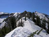 Summit Ridge
The peak lies at the northernmost end of the ridge extending north from South Thunder Mountain, which forms the divide between Thunder Bowl on the east and upper Bells Canyon on the west. The peak is located just to the northeast of upper Bells Canyon Reservoir, and features a long sloping ridgeline which culminates at the summit on the easternmost end of the ridge. The north face is a shear drop into Bells Canyon.
Despite its relatively low elevation, Bells Cleaver is a challenging objective which involves significant elevation gain and routefinding challenges even by its easiest approach. Its central postion in upper Bells Canyon provides a unique view of nearby peaks, including the east face of Lone Peak, and the west face of North Thunder Mountain.
USGS Quads:
Getting There
The Bells Canyon trailhead begins at 10245 South Wasatch Blvd. There is a parking area for the trailhead on the east side of Wasatch Blvd.To access the trailhead from I-215, take the 6200 South exit and follow Wasatch Blvd. south for approximately 6 miles to 10245 South. Park in the parking area on the east side of the road.
The trailhead can also be accessed via I-15 by taking the 9000 South Exit, then following 9000 South east for 6 miles to Wasatch Blvd. (by which time 9000 South has become 9800 South). Turn right (south) on Wasatch Blvd. and drive for 0.7 miles to the trailhead parking area, located on the east side of the road.
For GPS users, the trailhead is located at NAD27 12T 432036E 4490598N, el. 5,120 ft.
For more detailed information refer to the Bells Canyon Trailhead page.
Submitted by SP user Moogie737:
The listed TH still exists, but a newer one is located on the south side of 9800 South just 100 yards east of the intersection with Wasatch Blvd. This TH offers restrooms and drinking fountains. Elevation is @5,225'. The approach from here to the lower reservoir is longer than the one from the listed TH on Wasatch Blvd.
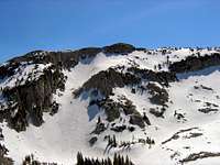
 Viewed from Thunder Bowl
Route Overview
The shortest and easiest ascent of Bells Cleaver is made by way of the West Ridge from Bells Canyon route. Refer to the route description for complete details.Much longer and more difficult approaches are possible, but these would typically involve a traverse from a nearby peak or surrounding canyon.
Red Tape
Bells Cleaver is located in the Lone Peak Wilderness Area. No fees or permits are required for hiking in this area, but the following regulations apply:The Bells Canyon trailhead passes through a residential area, so please show respect to the property owners.
Dogs are not permitted on this trail.
Camping
There are many possibilities for camping in upper Bells Canyon near the upper reservoir. Good camping locations can also be found along the trail further down in Bells Canyon.Water is available year round from the Bells Canyon stream and at upper Bells Canyon Reservoir. Treat before drinking.
Summit Views
 North Thunder
 View South
 Bighorn & Lone Peak
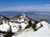 View West
 Looking North
Mountain Conditions
The 7-day forecast below is for the Wasatch Front valleys - expect considerably colder and more severe weather in the mountains.