
|
|
Mountain/Rock |
|---|---|
|
|
55.97293°N / 160.59608°E |
|
|
Hiking |
|
|
Summer, Fall |
|
|
9455 ft / 2882 m |
|
|
Overview
Bezymianny (Russian: Безымянный - lit. unnamed) volcano is part of the Kliuchevskoya volcanic group that also includes Kliuchevskoi, Kamen, Tolbachik, Zimina, Ushkovsky and Udina. This group is essentially at the epicentre of the interaction between the Aleutian Arc, the Kurile-Kamchatka Trench, and the subducting Emperor-Meiji Island arc (see article). While Kamen is no longer active and is generally falling apart, both Kliuchevskoi and Bezymianny do frequently erupt, characterised by effusive and explosive/lava dome building activity respectively. The proximity of the two volcanoes and timings of some of the eruptions has led to research into links between the feeding magma systems. The recent spell of activity at Bezymianny began in 1955 after 1000 years of presumed extinction. Magmatic intrusion and subsequent slope failure led to a lateral blast, debris avalanches and pyroclastic flows to the east, affecting an area of 500 sq km. This blast chute is still clearly visible as shown in the below figures. Following the eruption a lava dome grew in the horseshoe shaped crater that remained. In 1980 a similar style of eruption occurred at Mount St. Helens in the USA but few scientists outside Russia were familiar with its precedent here. The similarity in styles has led to many comparative studies between the two, and to other volcanoes besides. Though there is currently no direct threat from Bezymianny to nearby populations there can be substantial ash fall depending on prevailing wind directions from plumes reaching many kilometres in height.Please make sure to check out the last two 'External Links' for a documentary and great georeferenced photos inc. of the dome and crater. The weather was pretty lousy while I was there hence limited shots.
 Kliuchevskoya group
 | View Larger Map (if no image above, right-click area and refresh) |
Getting There
Bezymianny is fairly isolated and can be reached by chartered helicopter (Mi-8) out of Esso (more of a town with a small airport) or the much nearer Kozyrevsk (more of a village with a field in which helicopters from Esso will stop off at your request). The benefit of the latter is that you can actually see Bezymianny 27 miles to the ESE and can therefore get a better idea of weather and probability you can get there. Klyuchi town/settlement to the north might also be a possibility, there's some info on getting there via here. I've been told there is also a road that runs within perhaps 10 miles of Bezymianny to the west though I don't know any more details than that. Land access may also be gained via Tolbachik volcano, the page of which has some additional useful local access info. For details on reaching this region of Kamchatka, see the main Kamchatka Mountains page. There are various hiking trips (external link) that go through this area but I can't attest for quality or reliability etc. If you just wanted to walk there yourself then of course you could. Digital maps for all regions of Kamchatka can be ordered online, here being an example.  Kliuchevskoya group
 |  Helicopter unloading
 |
Red Tape and Danger

!!!
Getting around
There are generally 4 kinds of environment at Bezymianny, the plains surrounding the volcano, the flanks, the blast zone, and the crater area which contains the active dome. Despite appearances getting around can be tricky and some things need to be borne in mind. (All my images have co-ordinates so you can see what different areas of the volcano are like. Google Earth also displays user uploaded photos from Panoramio and there are many good ones for this area.)Plains: Semi-flat with the occasional hill, this is a sometimes grassy, sometimes boulder covered area full of streams and rivers. Many of these are fed by snowfields on the volcano and can be too wide, deep and fast flowing to cross easily. Such features make for barriers when hiking around with the only option to descend to find slower flows, or ascend till one finds the snowfield the river is flowing from and hike across it once you've found a stable portion. There are no trees or even bushes anywhere around so no protection from the elements.
 Icy water
 |  Icy bridges
 |
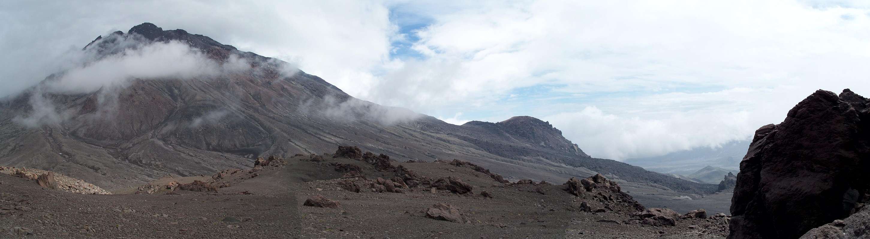
Flanks: The slopes of the volcano are generally made of fallout ash, blocky lava flows and mountains of loose scree. Many of the hills on the south side of the volcano in particular are in fact old lava domes that pre-date the current edifice. Being composed of degassed viscous andesitic-dacitic lavas they have no inclination to resort to more typical gentler angles of repose. The large dome jutting from the south flank of the edifice is called 'Expedition Dome'. Some areas have been hydrothermally altered and appear as bright yellows and reds. Depending on the weather and season you will either find snow filled valleys or rivers in certain places, again you may have to ascend or descend to find crossing points.
 Heading up the S side
 |  Heading down the SW side
 |
Blast zone: This region extends from the open east side of the crater down towards the river valley getting wide as it descends. Between the ridges on each side it is relatively planar though incised with some easily navigable undulations. Here you will find huge rocks of 5 m and larger, likely pieces of the dome that have come down during large eruptions. Ash and smaller rocks makes up the remainder of the material, often found to be blowing around when the wind picks up, so much so that you can entirely lose sight of where you're going. Goggles are a good idea. While in this zone you are particularly at risk from avalanching material from the summit region.
 Lower blast zone
 |  Lower, lower blast zone
 |
Crater and dome: Depending on the size of the dome itself, the highest point on Bezymianny is either the dome (external pictures here and here), or the crater rim surrounding it, and could change from year to year in line with dome growth vs. collapse rates and explosion occurrence. While the crater rim is easily accessible from many sides (pick something relatively gentle and just keep going up) the dome is most easily accessed from the crater breach on the east side given the gap between crater and dome and the steep crater walls. As for getting up the dome, it has been done on occasion, but is a fairly death defying prospect due to frequent hot rockfall and unpredictable gas concentrations. And it might explode. Not recommended and certainly not unless the weather is clear and stable and you've confirmed that activity is at background (i.e. standard) levels.
 |
 |
Camping
There are many potential camping possibilities around Bezymianny. One of the best for accessing the upper reaches however is the south side at around 55 55' 50''N, 160 35' 00''E. Here there is a large flat area with nearby drinkable water from a kind of spring as opposed to the streams. There is also a hut here with cooking facilities though I don't recall who owns it or whether it is routinely accessible. It may be for use by the Kamchatkan Istitute of Volcanology and Seismology only. Something to look into. Note that this region is a debris fan made from material that has avalanched down the mountain, i.e. it could happen again. If activity picks up you may want to consider heading up the big hill next to the camp or across the river valley and up towards Zimina.  Bezymianny with camp in front
 |  Camp from above
 |
Weather and wildlife
The clearest weather at Bezymianny is during September/October. During July and August the weather can be unpredictable and may even vary considerably during the day from clear skies to horizontal rain to snow. Clearly this makes helicopter access rather problematic. Dust storms can be a problem in places, particularly in the blast zone owing to the frequent strong winds and millions of tonnes of ash sitting around. In winter snowfall is considerable, to depths of many metres.The Kamchatkan brown bear is present in the area, you may see a few, but certainly more tracks. These should be considered dangerous particularly in the light of an incident in July 2008 where numerous geologists were killed by bears near a mine in eastern Kamchatka after having left food out. Based on abundant scat and the lack of much else around, grass appears to their primary food source.
The Yevrashka is abundant at Bezymianny, a ground-squirrel variant. While generally harmless and inquisitive, they will probably bite you if you try to touch them. Mosquitoes, foxes, mice, and the odd lemming might also be seen. If you're really unlucky you'll be plagued by a miasma of aggressive and unrelenting blue flies.
 Lame weather
 |  Ash storm
 |  Bears (Photo by waltraud)
 |  Yevrashka
 |  Blue flies
 |
Nearby volcanoes
Some assorted photos of what can be seen from Bezymianny.  Kamen
Kamen |  Kamen and Kluchevskoi
 |  Tolbachik
 |  Zimina
 |
External Links
Global Volcanism Program website
Kamchatka Institute of Volcanology and Seismology link
Recent photos by local scientists
Webcam feed
20 mins of documentary on Bezy (in French)
Great photos of Bezymianny here, all georeferenced reasonably correctly.