
-
 15649 Hits
-
 81.18% Score
-
 13 Votes
|
|
Canyon |
|---|---|
|
|
38.76020°N / 78.2142°W |
|
|
Hiking, Trad Climbing, Toprope, Scrambling |
|
|
Spring, Summer, Fall, Winter |
|
|
Overview


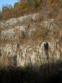

A wilderness canyon in the southeastern shadow of Mount Marshall, Big Devils Stairs is one of the most spectacular features of Shenandoah National Park. Cliffs up to one hundred feet high, making them among Shenandoah's tallest, line the rims and present numerous toproping and trad climbing possibilities in a wild, remote (for this part of the country) setting. In places, dense stands of mountain laurel line both sides of the trail that accesses the canyon, making late May and early June some of the prime times to visit.
A trail follows the east rim of the canyon all the way to the park boundary, beyond which (or from which) there is no legal public access due to private-property concerns. As the trail follows the rim, there is a stretch that skirts the clifftops and provides outstanding unrestricted views of the canyon, its west-side cliffs, and the rolling hills beyond. There used to be a trail through the canyon itself, but floods kept destroying the trail. It is still possible, however, to follow its faint remnants back up through the canyon or just to scramble/bushwhack along. Awesome route-finding skills aren't required; all one has to do is follow the stream to the head of the canyon until you are back on the trail. Also, consider scrambling up the west side of the canyon and returning to the main trail system via rugged terrain full of deadfall, dense undergrowth, and rock outcrops. The going this way is harder but is rewarding due to the wilderness feel and the nice views of the cliffs of the east rim.
The cliffs of the east rim are taller and steeper than those of the west rim, and they are easier to access since a trail crosses the top of them. If you like climbing in a wilderness setting and don't mind hauling your gear for about 2 miles, this is a nice place for you. But if your goal is just to climb something and a long approach is undesirable, consider going to Little Stony Man Cliffs instead, where you will find the longest and the best climbing in the park, and plenty of hiking company.
Route Details: One-way distance via the maintained trails is 3.4 miles, almost all downhill. Elevation gain on return is approximately 1350', with almost 1100' (in 1.6 miles or less) of it being from the bottom up to the head of the canyon.
Elevation Details: parking area-- 2655', head of canyon 2386', bottom of canyon 1300'.
From Gravel Springs Gap, hike north on the Appalachian Trail for 0.2 miles to the Bluff Trail (turn left). In 1.6 miles, look for the concrete post marking Big Devils Stairs Trail on the right. The trail leads 1.6 miles downhill, steeply at times, to the park boundary. There is a spectacular stretch that goes along open clifftops that yield excellent views south and west and into the canyon itself. The trail is very close to the rim of the canyon at times, so make sure you don't admire the scenery at the expense of your life.
From the bottom, follow the stream back up the canyon to get the full tour of the area.
Keep an eye out for copperheads, timber rattlesnakes, and poison ivy. Late spring through summer, carry insect repellent or prepare to swat and/or itch a lot.
Getting There
Drive into Shenandoah National Park at any of the four entrances to Skyline Drive and head to Gravel Springs Gap, which is between Mileposts 17 and 18 (closer to 18; miles are marked in ascending order from north to south). A sign in the parking area provides a diagram of nearby trails and suggestions for hikes.Red Tape
It costs $15 to enter the park, and that provides access for a week. Annual passes cost $30. The interagency pass, good for yearlong entry to areas managed by NPS, USDA Forest Service, USFWS, BLM, and the Bureau of Reclamation, costs $80.The park is open all year, but Skyline Drive does sometimes close after snow or ice storms. The park site does not give current road conditions, so call ahead (540-999-3500).
To reduce poaching, Skyline Drive is subject to closures during hunting season. The information below, copied and pasted from the park site, illustrates the 2006 restrictions—
From November 13, 2006, through January 6, 2007
Skyline Drive
• between Front Royal (Mile 0 at U.S. Highway 340) and Thornton Gap (Mile 31 at U.S. Highway 211), and
• between Swift Run Gap (Mile 65 at U.S. Highway 33) and Rockfish Gap (Mile 105 at U.S. Highway 250),
will be closed daily between 5:00 p.m. and 8:00 a.m.
The central portion of the Drive, between Thornton Gap and Swift Run Gap, will remain open for overnight access to Skyland Resort and Big Meadows Campground until those facilities close on November 26.
Then, beginning November 27, 2006, through January 6, 2007, the entire length of the Skyline Drive will be closed daily from 5:00 p.m. until 8:00 a.m.
Specific information about the dates for the current year is available on the park's website.
Camping
The closest campground is Mathews Arm (MP 22), which has water and flush toilets but no showers or a store (there is a seasonally open snack bar at Elkwallow, a short drive south on Skyline Drive). The campground is open from late May through October. It will usually fill on holiday and October weekends. The fee for a campsite is $15 per night (as of 2007, higher if you reserve).Backcountry camping is free, but you must get a permit. You can self-register at entrance stations.
External Links
Official park siteCamping info
Lodging info