
-
 12730 Hits
-
 83.1% Score
-
 16 Votes
|
|
Canyon |
|---|---|
|
|
38.53820°N / 78.3635°W |
|
|
Hiking, Trad Climbing, Toprope, Bouldering, Scrambling |
|
|
Spring, Summer, Fall, Winter |
|
|
Overview
Steeper, more rugged, and quieter than its famous neighbor, Whiteoak Canyon, the canyon cut by Cedar Run makes for a spectacular and strenuous journey through some of Shenandoah National Park’s most scenic areas. Far from being unknown or even seldom-visited, Cedar Run nevertheless offers a welcome, delightful escape from the crowds that flock to the canyon just over the ridge to the north.
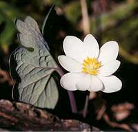
The trail through the canyon is memorable enough on its own, but SP members, many of whom like a little more adventure to their hikes, can find cliffs and boulders here in abundance. Numerous short gorges accessible only by leaving the trail beckon. When winter is cold enough, ice climbers can practice their trade on the frozen waterfalls and ice-coated cliffs they will find here. Wildflower and fall foliage enthusiasts will find endless subjects to explore with both their eyes and their cameras. Wildlife is always close by, though the popularity of the area makes sightings of the park’s signature species, the black bear, quite unlikely.
Getting There
There are two trailheads. The upper one is at Hawksbill Gap, between mileposts 45 and 46 along Skyline Drive, the paved road running north-south through the park. To get there from Luray or Warrenton (both in Virginia), take U.S. 211 east from Luray or west from Warrenton until the road crests the Blue Ridge and intersects the Thornton Gap entrance of Shenandoah National Park (this is about 40 miles from Warrenton). From the entrance station, where there is a fee (see RED TAPE), head south. People arriving from the south can access the park at Rockfish Gap between Waynesboro and Charlottesville or at Swift Run Gap between New Market and Ruckersville; then drive north to the trailhead. People arriving from the north can enter through the park’s northern entrance by Front Royal and then head south.The lower trailhead is more remote. At Sperryville along U.S. 211, look for signs indicating 522 and 231 and follow the directions to them. Turn right on 231. You can also reach 231 via 522 from Culpeper, and you can take 231 all the way from Charlottesville. After about 10 miles along 231, you reach a tiny town called Etlan. Look on the east side of the road for a small convenience store. Directly across the road from the store is SR 643. There should be a sign indicating access to Whiteoak Canyon. Follow this road for about 4 miles until you reach a stop sign. Turn right (a sign for Whiteoak Canyon should confirm this). You are now on SR 600, and it takes you all the way to the signed parking area and trailhead, almost at the very end of the road. Instead of turning into the parking area, continue straight for about 0.8 mi to the end of the road, which is where the Berry Hollow Fire Road begins. It is about 5 miles from the junction of 643 and 600 to the trailhead, and the drive takes about 15-20 minutes.
Route
I believe in experiencing Cedar Run from the bottom up for two reasons: the best parts are in the lower half of the canyon; and a trail network cuts across from the top of the Cedar Run trail to just above the upper falls in Whiteoak Canyon, enabling what might be the most spectacular loop hike in the East that doesn’t climb mountaintops. The route up Cedar Run climbs 3.3 miles to Skyline Drive at Hawksbill Gap; going by contour lines, the climb is 2200’, but ups and downs add more.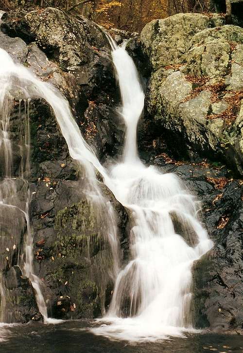
The trail is well-maintained, but because it is so steep, rocky, and/or slippery in places, I call this a Class 2 route. But if you are doing the loop, going up Cedar Run is safer than descending it, and the link to Whiteoak Canyon is mostly downhill. Trekking poles or stout hiking sticks may be helpful.

About 0.2 miles from the trailhead, the Cedar Run Trail branches off left (south), climbs a hill, and soon crosses Cedar Run--- this crossing is almost always very slick and sometimes deep. For the next mile, the trail climbs steeply while passing three significant waterfalls, all of which are best viewed after some steep, slippery off-trail scrambling. Although Cedar Run is generally smaller than Whiteoak Run, there are still many scenic cascades and pools. After passing the brink of the upper falls, the trail crosses Cedar Run again, and the canyon widens and the cliffs soon disappear. Cedar Run remains within sight and/or sound almost all the way to its upper end, but in dry seasons it can be little more than a trickle.

Some people training for longer, harder climbs or who just want a combination of mountain vies and waterfalls on the same hike ascend Cedar Run, cross Skyline Drive at Hawksbill Gap, and then hike to the summit of Hawksbill, the park’s highest point. This adds about 1 mile and 700 vertical feet to the hike (one-way). Please see the attached route page for more details.
Another great option is to hike the Cedar Run-Whiteoak Canyon Loop, one of the finest loop hikes in the park and in all the East (see attached route page).

Red Tape
To enter Skyline Drive, you must pay an entry fee and receive a seven-day permit. Currently, the fee is $15, but some parks have recently raised entrance fees. If you are paying cash, carry at least $20 to be safe.At the lower trailhead, there is a fee of $5 per person to hike the trails. This collection occurs mostly on weekends in spring, summer, and fall, but be prepared anytime. An Annual or America the Beautiful Pass covers up to 4 people.
Annual passes are available and a good idea for people who visit the park frequently but don’t do much other travel to national parks. The pass was $30 the last time I noticed. The America the Beautiful Pass is available, also. If you plan on visiting several parks within a year’s time, this pass is a great bargain at $80; it provides admission for you and all in a vehicle with you to all U.S. national parks and other federal fee areas on Forest Service, BLM, and Fish and Wildlife Service lands for one year.
Arrive early on weekends or go on a weekdays. On sunny weekends in spring through fall, the parking lots at both trailheads will be crowded and may even fill. This is particularly a problem at the lower end since you cannot park along the road. The crowds will also guarantee no peace and quiet and may even affect your ability to take good pictures. Starting at or shortly after dawn will make for a much better experience.
Shenandoah is black bear country. You are unlikely to see any bears in the Cedar Run-Whiteoak Canyon area, but you should still take proper precautions, especially with how you store food in the car. This is also raccoon country, and the raccoons can be quite adept at breaking into coolers and stealing food. Just lock all food in the trunk or in a covered area in the car, close your windows, and lock your doors.
To reduce poaching, Skyline Drive is subject to closures during hunting season. The information below, copied and pasted from the park site, illustrates the 2006 restrictions—
From November 13, 2006, through January 6, 2007
Skyline Drive
• between Front Royal (Mile 0 at U.S. Highway 340) and Thornton Gap (Mile 31 at U.S. Highway 211), and
• between Swift Run Gap (Mile 65 at U.S. Highway 33) and Rockfish Gap (Mile 105 at U.S. Highway 250),
will be closed daily between 5:00 p.m. and 8:00 a.m.
The central portion of the Drive, between Thornton Gap and Swift Run Gap, will remain open for overnight access to Skyland Resort and Big Meadows Campground until those facilities close on November 26.
Then, beginning November 27, 2006, through January 6, 2007, the entire length of the Skyline Drive will be closed daily from 5:00 p.m. until 8:00 a.m.
Camping
Camping options for the area are not very good. Big Meadows is about 10 miles south on Skyline Drive, and it fills most weekends from May through October, so arrive around noon when campers check out and sites open. Half the sites are reservable through the National Parks Reservation System (see park link below). There are three other developed campgrounds in the park, but they are all at least twice as far from Cedar Run as Big Meadows is. The campgrounds open in April, but they do not all open at the same time. They also close at different times, but all are closed from December through March.Backcountry camping is prohibited in almost all of the Whiteoak Canyon-Cedar Run corridor. Private campgrounds outside the park are too far from the trailheads to make reasonable places to stay.