
-
 7041 Hits
-
 75.81% Score
-
 6 Votes
|
|
Canyon |
|---|---|
|
|
38.22780°N / 78.7125°W |
|
|
Hiking, Scrambling |
|
|
Spring, Summer, Fall, Winter |
|
|


Overview
The canyons of Jones Run and Doyles River contain some of Shenandoah’s most spectacular woodland and water scenery. Waterfalls are the scenic highlights of the canyons, but the canyons are also excellent places to see immense trees, abundant wildflowers (March through November), dozens of small cataracts and crystal-clear pools, and the colorful foliage that draws thousands of visitors to the Blue Ridge on October weekends (hint—to avoid the crowds but still enjoy the colors, visit in early November, when there is usually still plenty of nice color but the crowds are gone). There are also numerous rock outcrops that can provide much scrambling and bouldering fun for children and adults alike.
Not quite as steep, narrow, and rugged as its neighbor, Jones Run’s canyon nevertheless has plenty of charm. The canyon is home to the park’s largest living tulip poplar tree (it was ten years ago when I read that, so things could have changed), and some of the canyon includes virgin areas with trees so huge that one can hardly imagine any being larger unless he or she has been to see the redwoods and the sequoias. Deer graze the woods and butterflies flutter through sunny openings. Closer inspections will reveal an incredible assortment of plant, fungal, and insect life. Don’t be surprised to see a large raccoon climb down from a tree and walk across the trail just ahead of you, or stroll through your backcountry campsite while you relax after dinner, as if you weren’t there. If you’re lucky, you’ll see a black bear. If you’re really lucky, you’ll see a bobcat.
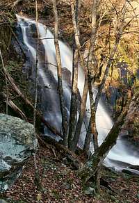
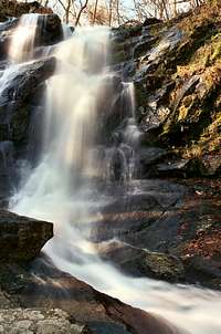
Jones Run Falls is the principal attraction, and its two steps are far enough to apart to be classified as upper and lower falls rather than as a single one. The upper one, the base of which the trail skirts, drops just 42’, but it seems taller since you can easily stand right beneath it. In October, golden trees frame the falls and delight hikers approaching from above. In early spring, look for trout lilies (they look like the glacier lilies common in the West) making a yellow carpet atop the soggy ground nearby. In summer, wildflowers grow on the mossy, mist-sprayed cliffs. Winter can turn the waterfall into an icy spectacle. The lower falls require some off-trail hiking and scrambling to reach, and they are in a rugged gorge setting.
Another nice thing about Jones Run and Doyles River is that although neither is a secret and both are quite popular, being in the South District (which sees less visitation and trail use than the park’s other two districts do), their trails are not nearly as busy as those in other well-known waterfall areas such as Dark Hollow Falls and Whiteoak Canyon.
A good trail runs through the canyon and connects with the Doyles River Trail, the Appalachian Trail (AT) and the Browns Gap Fire Road to form loops that many, if not most, visitors to these streams follow. The trail is pretty steep, though, dropping about 1300’ in 2.5 miles to its junction with the Doyles River, where the streams merge. The shorter loop really is not that much longer and harder than the down-and-back option, and it’s almost foolish not to hike it; the extra scenery is more than worth the extra effort. The shorter loop is described here because it must be done from the Jones Run Trailhead and covers all the best scenery of both canyons.
Loop Details (from Jones Run Parking Area at 2790’)—
• 1.7-2 miles: Upper and lower falls of Jones River.
• 2.5: Junction with Doyles River Trail near the streams’ confluence at 1500’.
• 3.2-3.5: Lower an upper falls of Doyles River.
• 3.8: Browns Gap Fire Road: Turn left unless you are staying at the Doyles River Cabin, in which case you continue for 0.6 mi to the spur accessing it.
• 5.5: Junction with AT. Head south on the AT.
• 2.7-3.0: Lower and Upper Falls on Jones Run.
• 6.7: Jones Run Parking Area.
Getting There
Enter Shenandoah National Park’s Skyline Drive at any of its four access entrance stations and drive to the Jones Run Parking Area at MP 83.8. This requires driving SOUTH unless you enter at Rockfish Gap.The closest campground is Loft Mountain, which has showers, water, flush toilets, and a store. The access road for the campground is at MP 79.5. The campground is open from mid-May through October, and you cannot make reservations to stay there. It is the park’s largest campground, but it will usually fill on holiday and October weekends. The fee for a campsite is about $17 per night.
Red Tape
It costs $15 to enter the park, and that provides access for a week. Annual passes cost $30. The interagency pass, good for yearlong entry to areas managed by NPS, USDA Forest Service, USFWS, BLM, and the Bureau of Reclamation, costs $80.
The park is open all year, but Skyline Drive does sometimes close after snow or ice storms. The park site does not give current road conditions, so call ahead (540-999-3500).
To reduce poaching, Skyline Drive is subject to closures during hunting season. The information below, copied and pasted from the park site, illustrates the 2006 restrictions—
From November 13, 2006, through January 6, 2007
Skyline Drive
• between Front Royal (Mile 0 at U.S. Highway 340) and Thornton Gap (Mile 31 at U.S. Highway 211), and
• between Swift Run Gap (Mile 65 at U.S. Highway 33) and Rockfish Gap (Mile 105 at U.S. Highway 250),
will be closed daily between 5:00 p.m. and 8:00 a.m.
The central portion of the Drive, between Thornton Gap and Swift Run Gap, will remain open for overnight access to Skyland Resort and Big Meadows Campground until those facilities close on November 26.
Then, beginning November 27, 2006, through January 6, 2007, the entire length of the Skyline Drive will be closed daily from 5:00 p.m. until 8:00 a.m.
Shenandoah is black bear country. Store food properly. Backcountry bears are rarely a problem, but observe backcountry etiquette as diligently as you would (or should) the rules of developed campgrounds.
Camping
The closest campground is Loft Mountain, which has showers, water, flush toilets, and a store. The access road for the campground is at MP 79.5. The campground is open from mid-May through October, and you can make reservations to stay there, though only 10% of the sites are reservable (see park link for more details). It is the park’s largest campground, but it will usually fill on holiday and October weekends. The fee for a campsite is $15 per night (as of 2007, higher if you reserve).
Backcountry camping is free (no fires allowed), but a permit is required. Permits are available at entrance stations and ranger stations and can often be done in self-serve style.
The Potomac Appalachian Trail Club (PATC) operates and maintains several cabins in and near the park, and the Doyles River Cabin, one of the nicest, is a short trip from the loop route described above. The cabins are rustic and have no electricity or running water but do have fireplaces, wood-burning stoves, bunks (with mattresses and blankets, if you want them), and they are the best places to stay in the park. These cabins can be reserved, but members get first dibs, and it can be very difficult to reserve one on a weekend. See the links section for a link to the PATC site.
External Links
Official park site
PATC site