
|
|
Mountain/Rock |
|---|---|
|
|
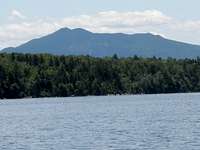
45.48000°N / 69.71°W |
|
|
Piscataquis |
|
|
Hiking, Skiing |
|
|
Spring, Summer, Fall, Winter |
|
|
3196 ft / 974 m |
|
|
Overview

Getting There
In order to find your way to the trail head you mush follow Rt. 15 into Greenville. You want to take a left in the center of the town towards Greenville Junction, and Rockwood, staying on Rt. 15. From here you will pass a series of local shops, as well as the area high school, following the road for about 5 miles. Look out for the sign that signifies the Squaw Brook campground on the left. When this is reached you want to take this left an follow the dirt road for 1.5 miles until you reach the trail head. There is a parking lot and sign to tell you where you are.The Trail

Camping
There is nothing that says camping is not permitted; however, there is really no place to do so unless you stealth it. Lily Bay State Park is located about 10 miles outside of Greenville and offers full camping accommodations, with views of Big Moose Mountain as well as the surrounding area.Red Tape
You can climb this mountain anytime of year, however the most hazardous season would be in June when the Black Fly population can be a bit overwhelming.Hitsory of the Mountain
Many might be unfamiliar with Big Moose mountain, because before the year 2000 the mountain was known as Big Squaw. The state felt the previous name was offensive to the Native American population, and decided to make the change. However the Ski resort which encompasses a portion of the mountain still bears the name Squaw. Legend has it, Squaw was the name of old Chief Kineo’s wife who left him because he was awful man; she supposedly died on the mountain that once bore her name. Today the mountain and area that surrounds it is in jeopardy, due to the Plum Creek timber company which has plans to develop much of the Moosehead Lake region. The area, which in past times was a wood harvesting capital, has seen much change. Currently the region enjoys tourism as its staple of income, but with plans to develop it further, the pristine wilderness as we know it today could vanish into a metropolis of weekend get away resorts. This land must be persevered, because the region is one of the few untouched places left for those who wish to enjoy nature without the burden of big city life knocking on the door. If you are interested in countering Plum Creek’s developmental plan you can contact the Natural Resources Council of Maine by visiting their website at http://www.nrcm.org/.
JohnSimko - Apr 16, 2012 9:20 pm - Hasn't voted
DevelopmentPlum Creek has created the largest conservation easement and conservation fee acquisition project ever for the Moosehead Lake Region and is working with the State of Maine Bureau of Parks & Lands to define new trail development. Plum Creek is not the devil - there are a lot of good things in the works for the region that won't, in my opinion, change the hiking experience of visitors to places like Big Moose Mountain: it will enhance it.
Sheazula - Apr 30, 2012 10:37 am - Hasn't voted
We can only hope...The hiking experience may improve - but with that will come increased development. While the outlook seems better than it did say 4 years ago, one can only hope that Moosehead does not become the next Winnipesaukee.