
|
|
Mountain/Rock |
|---|---|
|
|
46.07403°N / 68.86767°W |
|
|
Piscataquis |
|
|
Hiking |
|
|
Spring, Summer, Fall, Winter |
|
|
3225 ft / 983 m |
|
|
Overview
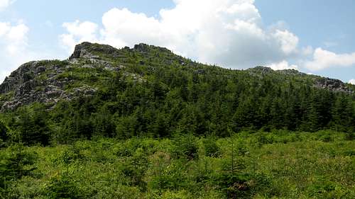
The Primeval nature of this mountain is stunning. As you stand on the North shore of South Branch Pond an extraordinarily rugged mass looms nearly half a vertical mile above the water, and just West of The Traveler. While gazing at its sheer West face that dives dramatically into the glacial valley that separates it from the Katahdin Massif, the ancient volcanic rhyolite that litters its slopes seems to invite hikers with the promise of an unbelievable experience. Unable to see the true peak from the shore one cannot grasp the intense exposure, vertical gain, and steepness of the little known Peak Of The Ridges. However, if you are up to the challenge you will gape upon some of the most jagged, iron bound country in Maine ( if not the whole East), and being the only other Mountain (in Maine at least) to have a "Knife Edge" it is a substantial peak that should be appreciated, cherished, and most of all, respected. Peak Of The Ridges (right) lies just west of the fog enveloped Traveler.
Getting There
From Bangor, take 95N until exit 264 for ME-158 toward ME-11/Sherman/Patten. Turn left onto ME-158, then a slight right onto ME-11. Follow ME-11 then make a left onto ME-159/Shin Pond. Continue onto Grand Lake rd and enter Baxter park onto the park tote road, then make a left at the signs for South Branch Pond.Red Tape
Baxter Park limits the number of people allowed to enter each day so get in early (about 5:30 am during the busiest times). You also must sign in and out at the ranger station letting them know how many people are with your party, what time you departed, name, and whether you are camping or day-use.Camping
South Branch Pond CampgroundThere are 12 lean-tos, 21 tent/trailer sites, and an 8 person bunkhouse. These are all open May 15- Oct. 15. Fishing is allowed in the Ponds (fly fishing only), and you can rent canoes at the ranger station.
Outlying Sites
Upper So. Branch (1 Lean-to)
Pogy Pond (1 Lean-to)
So. Branch Canoe Site (1 Tent site, 1 Lean-to)
(ALL OUTLYING SITES ARE EITHER HIKE OR CANOE-IN)
Trout Brook Farm Campground
Holds 14 tent/trailer sites, 1 lean-to, and 4 group sites (site #1 holds 8 people, group sites 2-4 hold 14 people each). Fly fishing only.
Outlying Sites
North West Cove (1 Tent site)
Boody Brook (1 Tent site)
Little East (1 Lean-to, 1 Tent site)
Webster Stream (1 Lean-to)
Billfish Pond (1 Tent site)
Webster Outlet (1 Lean-to, 1 Tent site)
Long Pond Outlet (1 Tent site)
Little Coffeelos (1 Tent site)
Long Pond Pines (1 Tent site)
Telos Cut (1 Tent site)
Lower Fowler Outlet (1 Tent site)
Hudson Pond (1 Lean-to)
Lower Fowler Pond (1 Tent site)
Togue Ledge (1 Tent site)
Middle Fowler North (1 Tent site)
Pine Point (1 Tent site)
Middle Fowler South (1 Tent site)
Second Lake (1 Tent site)
K-P Dam (1 Tent site)
(ALL OUTLYING SITES ARE EITHER HIKE OR CANOE-IN)
For additional info. you can see Baxter State Park
Weather
In general for every 1000 feet you climb it cools by approximately 3-6 degrees (depending on other atmospheric factors), that combined with the Northernly latitude, elevation gain, and little-to-no cover on most of the trail can make for some hairy situations (if not prepared, even in the summer). This area by and large has very harsh winters with mild summers, but you can't rule out a snow/ice storm at any time. Wind Chill is a huge factor in this region, most of the entire Traveler Circuit is exposed SO PLEASE BE PREPARED.WEATHER FOR MILLINOCKET