
|
|
Route |
|---|---|
|
|
40.45600°N / 109.2144°W |
|
|
Off-trail route |
|
|
Most of a day |
|
|
Class 2+ |
|
|
Approach
To get to the trailhead, drive to the small town of Jensen. This is located between Vernal and the Colorado/Utah state line on Highway 40.
From Jensen, turn north on Highway 148 and the road marked for Dinosaur National Monument. Drive through to the entrance station and continue along the paved road. Take a right on the road posted for the campground. Drive past the campground (don't turn left to the campground), cross the Green River on a bridge and reach another junction. Turn left on the road marked for the petroglyphs and the Josie Morris Cabin. Once you cross the park boundary, look for a place to park.
There are other ways to climb South Split Mountain. A shorter route would be to cross the Green River at the Split Mountain Picnic Ground and boat ramp, but you would need a boat for this. The Daniels Ranch blocks any other shorter routes to the mountain, and the route on the route page bypasses any ranch land.
 |
Route Description
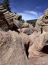
This route requires a topo map. From the car-park, climb up the steep rubble hill to the north. Head northwest a short distance to the rim of a drainage. Drop in to the drainage (with scrambling) and climb out the other side. Head west and route-find down into the next drainage. Keep an eye out for petroglyphs. Follow the drainage up to and past some interesting rock formations and butresses. The drainage divides several times, so use a topo map and follow the main draige that heads towards the south side of South Split Mountain. Stay in the main drainage until it is near the face of the anticline (I left a few cairns, but they might disappear). Turn left and into the drainage that heads towards Point 5582. Follow this new main drainage toward the divide (very minor pass) northeast of the mentioned point. From here, head northeast and towards the anticline face. Climb up the anticline between the two drainages. Stay on this minor ridge all the way up the face of the anticline. This is obviously a route used frequently by bighorn sheep and you will see many tracks and other "evidence" of their presence. When the drainage to the left peters out, you can contour northeast, gaining altitude slightly and towards the eastern summit of South Split Mountain. Continue contouring to the minor saddle east of the summit. From there, head west along the ridge and to the summit. The views are absolutely breath-taking! This has got to be one of the all-time best viewpoints in the world. Split Mountain Canyon is directly below. You can hear SOB Rapids below, but these are just out of sight. To the west are many spectacular pinnacles of South Split Mountain, including the highest summit. Split Mountain is to the north. The High Uintas can be seen to the far west. To the southeast is Blue Mountain. Plan to spend some time soaking up the incredible views. Return by way of the same route. The route is seven miles round trip and with 2200 feet elevation gain (of which most is on the face of the anticline). The route isn't difficult, but is slower than hiking on a marked trail.
 |  |  |
Essential Gear
A good pair of boots is needed.