
-
 18860 Hits
-
 83.1% Score
-
 16 Votes
|
|
Canyon |
|---|---|
|
|
44.99321°N / 110.54649°W |
|
|
Hiking |
|
|
Spring, Summer, Fall |
|
|
Overview
The Black Canyon of the Yellowstone covers an extensive stretch of the Yellowstone River near the northern border of Yellowstone National Park. This is a hiking and backpacking canyon, not a canyoneering destination. It’s characterized by spectacular scenery along the Yellowstone River, with interesting geology at the upstream sections.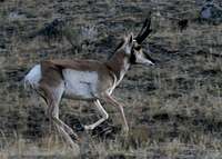 Running Buck
Like most of Yellowstone NP, the Black Canyon is good wildlife territory. In the fall I saw a lot of pronghorn on the Rescue Creek Trail, and some bighorns on the lower slopes of Mount Everts. We also saw deer near Blacktail Deer Creek, appropriately enough, and I’ve seen evidence of wolves on the south side of the Yellowstone River in various places. Elk and bison use various stretches of the canyon as a travel corridor in spring and fall. This means there will be winter kill in the spring that attracts bears, so be bear-aware. In addition, this is the only part of the park low enough for rattlesnakes, and I’ve also seen gopher snakes and many garter snakes.
 Monument Plant
In my June trips, I’ve found that its approach trails from the south all have good wildflowers, as does the narrowest part of the Canyon. The hike out to Gardiner is too exposed for most species, but you’ll see cacti that may or may not be in bloom. Many stretches have lots of grass that ticks love in June.
Because it’s in the part of the park with the lowest elevations, the Black Canyon is free of snow longer than anywhere else in the park. This makes it one of the first places to melt out in the spring and summer, so it's good for early season trips. The Canyon also has treeless stretches that are exposed to the hot summer sun, such as the descent to Hellroaring bridge, Rattlesnake Butte to Rescue Creek trailhead, and the south-facing, burnt-brown last few miles above Gardiner. I’d avoid all those in the heat of the day.
 Northern Mule's Ears
The Black Canyon is best hiked downhill as a shuttle hike, over one to three days depending on your interest and inclination. Though you’ll be traveling downstream, you regularly have to ascend 100-300 feet to go around rapids or falls. There are lots of backcountry sites along the river, but reserve them early.
Getting There
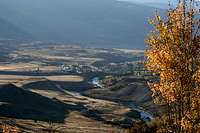 Gardiner from Rattlesnake Butte
Any road to Yellowstone can get you to the Black Canyon, but the most natural approach is through Gardiner. From I-90 in Montana (access to Bozeman and other airports), take Hwy 89 south from Livingston, climbing gently through Paradise Valley to Gardiner.
Once in Gardiner, see trailheads below.
Trailheads, from west to east
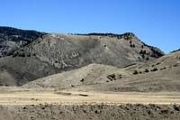 Rattlesnake Butte
Rescue Creek. This trailhead does not provide access to the canyon itself but does provide access to Rattlesnake Butte and Turkey Pen Peak, which overlook the canyon.
 Bridge at Blacktail Creek
Yellowstone River. This trailhead is located in the town of Gardiner, next to the LDS Church. From just north of the river on Hwy 89, turn east and go up the hill. The road is marked, but the sign is not easy to see from all directions. This makes a nice exit spot, despite the annoying 150-foot ascent from the river at the very end.
Blacktail Creek. On the Grand Loop Road between Mammoth and Roosevelt, five miles east of Mammoth. Taking the Blacktail Deer Creek Trail provides excellent access to the middle reaches of the Canyon, and the start of a 12-13 mile shuttle hike to Gardiner. A shorter shuttle goes out the Rescue Creek Trailhead with access to Rattlesnake Butte and Turkey Pen Peak but avoids the Canyon.
 Bridge on Hellroaring Trail
Crevice Creek. This is in the Gallatin National Forest, north of the park. I haven’t used this one and can’t provide further information.
 View of River
Hellroaring. This is about three miles west of Tower on the road to Roosevelt. I’ve seen the most cars parked here, and it’s close to a gaggle of backcountry sites along Hellroaring Creek (sites 2H1-2H9). You have to ford Hellroaring Creek or hike a mile up to a stock bridge to get to the Yellowstone River trail.
Tower. From the trailhead near the visitor center, there are two trails that take you across Pleasant Valley and around Garnet Hill to where you connect with the Hellroaring Trail. The geology clearly visible on the north side of the river is interesting through this stretch.
Red Tape
 Turkey Pen Peak from the River
 View from Elk Plaza
You have to pay the Yellowstone NP entrance fee unless you have the annual interagency pass.
Backcountry camping requires a permit, and I’d strongly recommend making reservations in advance using the park reservation system. Consult the park website for more information.
Camping
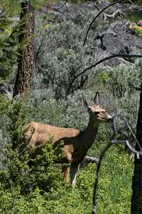 Mule Deer
There are nearly 20 backcountry campsites in or near the Black Canyon. Bill Schneider's Hiking Yellowstone National Park ranks all of them with one to five stars. He considers privacy, views, access to water, and other factors affecting your happiness. His book is a valuable resource for trip planning.
 Gopher Snake Romance
Outside the Canyon, the nearest park campsites are at Mammoth Hot Springs and Slough Creek.
External Links
 Showy Larkspur
Yellowstone National Park official site.
 Alpine Aster
Nice pictures of the canyon that differ from mine can be found here.
b. - Jul 24, 2008 2:15 pm - Hasn't voted
Nice Work!One thing I would mention: This trail opens early in the season, and is therefore one of the first places you can backpack in Yellowstone each year. There are usually lots of winter kill carcasses along the lower stretch, and therefore, lots of bears.
Arthur Digbee - Jul 24, 2008 2:45 pm - Hasn't voted
Re: Nice Work!Good points both, I'll include them. Thanks for the compliment and the suggestions!