
-
 22342 Hits
-
 78.27% Score
-
 9 Votes
|
|
Mountain/Rock |
|---|---|
|
|
44.74270°N / 107.381°W |
|
|
9500 ft / 2896 m |
|
|
Overview
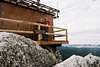
Black Mountain is a mountain in the northern Big Horn Mountains of north-central Wyoming. It can be seen prominently to the south of US 14 as it climbs to Burgess Junction. From the top there are panoramic views of the northern Big Horns. You can see Cloud Peak to the south, and probably up to 100 miles of prairie to the east. While it is one of the most popular hikes in the area, it would be difficult to find a hike anywhere in the Big Horns that could be considered crowded. This area seems to be largely undiscovered by the general public, and that saves it from being over run as some of Wyoming's other wild places are. We saw 4 people on our hike. The first mile of the hike is 4WD road, which can be driven if you have a high clearance vehicle. The two miles are on a trail up the mountain. At the top is a fire lookout, one of two left in the the Big Horns. It is still used during extreme fire seasons. The mountain provides a nice 3-4 hour, 6 mile hike with about 1500 ft. of elevation gain. The only issue for a flatlander might be altitude, but if any time at all is spent in the mountains previous to the hike, you should be fine.
 |  |
Getting There
Black Mountain is located in Big Horn National Forest. From the east, take the US 14 exit off of I 90 in Ranchester. Take US 14 west for 22 miles. Then go south on Forest Road 16. It will be marked. Go about 8 miles, and there will be a road on your left marked with a sign. This is Forest Road 222, which is impassable to low clearance vehicles. Park along here, or if you have a high clearance vehicle, drive the mile to the trailhead. From the West, take US 14 east from Burgess junction about 10 miles, go south on Forest Road 16, and follow all above steps.
Red Tape
None that I know of.
When To Climb
Typical Season is june-september. I would imagine it could be climbed during the winter, but care would need to be taken near the top, as the last 1/4 mile is over and through granite boulders, and it would get slick. The Big Horns also fall prey to the same type of afternoon T-storms that the rest of the Rockies get, so watch for changing conditions in the last quarter mile and at the top.
Camping
There are a number of forest service campgrounds in the area where camping can be had for a fee. Camping is also permitted anywhere in the National Forest, as long as you are 1/2 mile away from the main roads. Further information can be found at http://www.fs.fed.us/r2/bighorn/
Mountain Conditions
The only way that I know of to check conditions would be to call the Tongue Ranger district @ (307)674-2600