
-
 7171 Hits
-
 84.82% Score
-
 19 Votes
|
|
Mountain/Rock |
|---|---|
|
|
44.15780°N / 107.1305°W |
|
|
Washakie |
|
|
Hiking |
|
|
Spring, Summer, Fall, Winter |
|
|
9620 ft / 2932 m |
|
|
Overview
 The Washakie County Highpoint?
The highest point in Wyoming's Washakie County is not a spectacular summit with awesome views, and due to the thick forests in the area, it is not known for sure which of three points that lie within a half mile of each other is the highest. For highpointers wishing to claim the county, all three points must be visited.
While this is not a typical summit experience, two of the points do have some pretty views of the southern part of the Big Horn Range. It is also a fun exercise in using a GPS to find these spots and decide for yourself which is the highest. All three lie just above the 9600-foot contour, and they are most likely between 9,610 and 9,620. One point is located in the forest about a quarter of a mile north of the Cloud Peak Scenic Byway along the border between Washakie and Johnson counties, and the other two are rock outcrops just south of the highway.
Getting There and Hiking Information
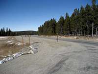 Canyon Creek Road sign
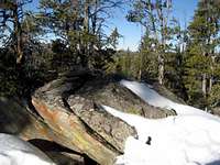 The western point
From Ten Sleep, Wyoming, travel east on Highway 16 (also known as the Cloud Peak Scenic Byway) for just over 25.5 miles. Look for a dirt road that turns right called Canyon Creek Road very close to the green sign letting you know that you're crossing into Johnson County. Pull off the highway and park anywhere in this area.
To reach the two rock outcrops, head south across the field and hop the fence (no posted signs in the area), and go up the hill. There is a small saddle between the rocky areas, both of which offer a little scrambling if you're so inclined. In my opinion, I think that the westernmost of the rocks is the higher of the two, but it is impossible to sight between them due to trees. The two small circle contours on this map are the two outcrops.
West Point: N44.15774, W107.13078
East Point: N44.15734, W107.12988
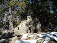 The northern point
 Cairn on the eastern point
For the other point, a GPS is a necessity because it is nothing more than a spot in the middle of the forest. Head north into the forest across the highway and hop another fence and go to the coordinates on the county line. There is a small rock protrusion on the side of ridge that has a rock cairn on it marking the approximate highpoint, but the actual spot is probably a little ways down the ridge to the west. In true county highpointer fashion, it is necessary to tromp around the area to ensure that you stand on the highest point. (Yes, this can be a goofy hobby at times!)
North Point: N44.16414, W107.12868
The total distance and elevation gain reaching all three points is about one mile and 300 feet.
Red Tape and Camping
There are no fees or permits required to hike in this area, and the road to the base of High Park Lookout is drivable in 2WD unless it is very muddy. Fast-developing storms are common throughout the Big Horns, so keep an eye on the weather; however, this hike is so short that this shouldn't be a problem.Black bears, moose, and mountain lions can encountered at any time in this area, so be prepared with bear spray and know how to deal the situation if you happen to meet one of these animals.
Places to camp in the Big Horns are numerous, with the majority of the range being open to dispersed camping. Camping is not allowed within 100 feet of lakes or streams, or within 1/4 mile of major roads. Camping is limited to fourteen days at a site. For complete rules and regulations, visit: http://www.fs.fed.us/r2/bighorn/recreation/camping/
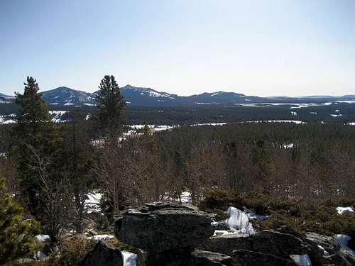 Summit view south
External Links
Lists of John pageCounty Highpointer's page