
|
|
Trailhead |
|---|---|
|
|
40.57972°N / 105.85548°W |
|
|
Larimer |
|
|
Spring, Summer, Fall, Winter |
|
|
9520 ft / 2902 m |
Overview

Usage is heavy in both summer and winter.
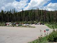
Facilities-Small paved parking lot / no restrooms / no water. Primitive restrooms are available a couple hundred yards east, on the south side of the road.
Directions


Destinations


Clark Peak - 12,951
Lewis Peak (FKA Sickle Mountain) - 12,654
South Rawah Peak - 12,644
Snowbank Peak - 12,522
North Rawah Peak - 12,473
Cameron Peak - 12,127
Dodad Peak - 12,046
The Blue Lake Trail leads, as one might guess, to Blue Lake. The trail continues beyond the lake, tying into the West Branch Trail on the north side of Blue Lake Pass.
The Sawmill Trail is also accessible from this TH. It is located about 150 yards west of the parking lot and heads into the upper Sawmill Creek drainage and the crest of the range just south of Clark Peak.
Camping Options
None at the TH but some dispersed sites are available along the Long Draw Rd which is opposite the TH. Camping is also available 10 miles down the Long Draw Rd at the Long Draw CG and at Chambers Lake CG east of the TH. Additional camping opportunities may be found at campgrounds farther down the Poudre Canyon.For nearest services, see: Zimmerman Lake TH.
Maps
Arapaho and Roosevelt NF
USGS Quads
Chambers Lake
Clark Peak
Rawah Lakes
Backcountry Adventure Map for Colorado’s Rawah Wilderness