
|
|
Mountain/Rock |
|---|---|
|
|
40.62307°N / 105.89464°W |
|
|
Larimer |
|
|
Hiking, Skiing |
|
|
Spring, Summer, Fall, Winter |
|
|
12127 ft / 3696 m |
|
|
Overview
 Pink granite on the summit
 Views from the summit
 Cameron Peak Summit panorama
Hiking Info
 Blue Lake
 Blue Lake PassMid-way up Cameron
Red Tape
The only Red Tape in the Rawah's is the snow. The Medicine Bow Mountains are a notoriously snowy range. Roads to the the trail heads open late May to early June (with the exception of the Blue Lake Trailhead which can be open year round because it is along HWY 14). For current conditions, HERE. If the roads are still open, access higher wont normally be snow free until mid-June. Bugs are bad in June as well.Camping
Camping can be found all over the Rawah Wilderness and around Cameron Peak. Camping in the Blue Lake and Hang Lake area is closed!! You can pretty much camp anywhere in the area except for next to these lakes. Here are some camping rules and regulations:-Camping and fire building are prohibited within 200 feet of all lakes, streams and trails to protect water quality, sensitive vegetation and to help assure solitude.
-Camping is prohibited within one-quarter mile of Blue Lake and Hang Lake. Do not camp or use a fire in re-vegetative sites. These areas are seeded with native, high-altitude grasses and need protection to grow.
-Campfires are prohibited in the alpine areas above 10,800 feet. Campfires consume scarce vegetation and leave permanent scars on the fragile soils of the area.
-No camping around Blue Lake or Hang Lake
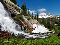 Rawah Falls...gorgeous!
The closest established camping can be found at Chambers Lake Campground.
Also, if your in the area, be sure to check out Rawah Falls right below Timber Lake! There is good camping there as well!
Getting There
 Very cold water in Blue Lake
From Fort Collins to the West Branch Trailhead- Head west on HWY 14 (Poudre Canyon Highway). Follow the Poudre Canyon Highway for 51 miles until you reach CO Road 103 (if you reached the Chambers Lake Campground you have gone too far). Take a right and follow this road around the east side of Chambers Lake. Follow this nice dirt road for just under 7 miles until you reach the West Branch Trailhead on the right-you cant miss it. For other trailhead information, see the page on the Medicine Bow Mountains.
Blue Lake Trailhead- If you are starting at the Blue Lake Trailhead, instead of taking a right on CO Road 103, keep going straight on HWY 14 for 2.2 miles and until you reach the Blue Lake Trailhead on your right.
External Links
Rawah WildernessArapaho National Forest Service page for the Rawah Wilderness
Current Weather Conditions
Current weather for Cameron Peak as forecasted by NOAA.