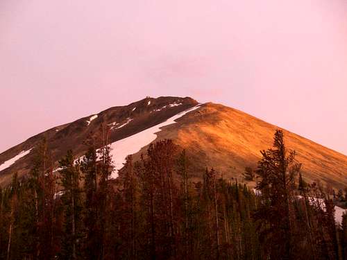
Borah Aftermath
![Summit Shot 1]() Me on Borah
Me on BorahAfter a 13 hour day on Borah, nothing is better than a familiar face and some ice cold Gatorade waiting for you at the trailhead. This is how part II of my story begins…..
Being revived by the Gatorade and getting my car jump started, my
Dad and I headed off for Challis to continue the weekend of Idaho mountaineering. We left the trailhead just after 8 pm and since we were somewhat unfamiliar with the area we decided to fine a motel instead of wandering around all night trying to find a campsite. Of course we wanted to camp but this turned out to be a very good idea. A day of slogging through snow and loose rock at 12,000 ft. can really make you tired and sore! But there’s nothing that can make you feel better (and ready for more) like a hot shower, a good meal, and a real bed (and maybe some Ibuprofen). It was good to be able to catch up with my Dad without having to worry about finding a campsite, swatting mosquitoes, and pitching a tent in the dark.
After settling into our room and getting all cleaned up and feeling more human we discussed our plans for the next day. We had seen our destination on our way into Challis but we poured over maps and climbing beta in
"Idaho: A Climbing Guide" until it was time to turn in for the night.
White Mountain and
South Twin were on the books for tomorrow. Needless to say, I didn’t have any trouble sleeping that night, and in fact I slept in too long the next morning.
On Our Way
We checked out by 11 am the next day and headed for the Twin Peaks area to begin our adventure in the Salmon River Mountains. These mountains cover more than 7,300 square miles of Central Idaho. Most of this area lies within or near to the Frank Church-River of no Return Wilderness, and many of the mountains here are fantastically rugged and difficult to get to. Luckily though, the area with the highest peaks is not as hard to reach with a good vehicle, tolerance for bumpy narrow roads, and a willingness to hike. These peaks, in the southeast corner of the range, are just as rugged as any other Idaho mountain but don’t require a multi-day trek just to get to as many other peaks in this area do. This region was also one that Dad and I have always been curious about as well.
![White Mountain Map]() Map of the Area
Map of the Area
It seems that geographical curiosity runs in my family. I swear my grandpa has been on every back road and trail of every state, and knows someone in every town! My Dad also has the same sense of wondering what’s around the bend or over the ridge. It seems that I’ve inherited that gene as well so there’s nothing we love more than filling in a blank spot on the map. As we approached the Twin Peaks/White Mountain area this particular blank spot was beginning to reveal its beautiful secrets to us.
In order to reach our destination we had to take the Sleeping Deer Road which leads past Twin Peaks and into the heart of the Frank Church Wilderness. The road was good but narrow and includes a few surprises including a herd of pack mules and horses that stubbornly like to stand on the road. The scenery changes dramatically, beginning with farmland, changing into desert, and eventually blurring into alpine forest as you progress up the road. Higher up Bear Creek tumbles happily along the side of the road, its cool, clear waters flowing from the Twin Peaks Lakes and into the Salmon River.
![The Guards of Sleeping Deer Road]() The Mules on the Road
The Mules on the Road![Twin Peaks Lookout Road]() The Narrow Road
The Narrow Road
Eventually we reached the beginning of the road leading to the summit of South Twin and the lookout it houses. Driving up this road was quite an experience! It was extremely narrow, and at the time we were on it its narrowness was exacerbated by the fact that there was still some partially melted snow banks in some places. The scariest part about this road though is its steepness on the downhill side. Although it wouldn’t be too much trouble to navigate on foot, it sure wouldn’t be a great place to roll your vehicle.
Finally we reached the starting point for our first day of climbing. By that time it was almost 1 pm but the weather was good albeit windy. From the lookout road White Mountain lay to our South while the Frank Church Wilderness extended as far as we could see to the North and West. Everywhere there was color. Red, white, and green rocks made up the mountain peaks while the valleys were blanketed with green forests, green lakes, and green grass, all under a brilliant blue sky. The scene was absolutely gorgeous!
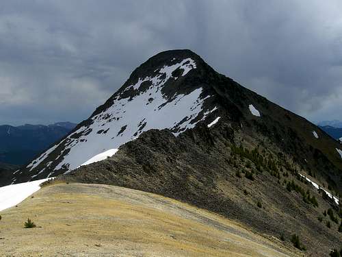
White Mountain
![White Mountain from South Twin]() White Mountain from where we parked.
White Mountain from where we parked.After taking it all in for a moment we had a bite to eat. My Dad decided he didn’t want to come along for White Mountain but he wanted to finish hiking up the road to the summit of South Twin. He gave me a radio so we could stay in touch and I headed off across the ridge connecting the two mountains. The first mile of the hike was generally pleasant with the exception of a side hill across loose dirt and deadfall, but that was only a short distance. I reached the main ridge within an hour and began climbing up towards the imposing towers farther above me. Before long I came to the brilliantly white rock from which White Mountain gets its name. This rock, however, looked quite yellow when compared to the snow still lingering on it.
![White Mountain s East Face]() White Mountain's East face.
White Mountain's East face.![White Mountain s North Ridge]() White Mountain's North Ridge
White Mountain's North Ridge![White Mountain s White Ridge]() White rock on White Mountain
White rock on White Mountain
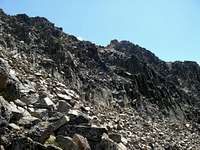
By now I was nearing the 10,000 ft. mark and had a clear view of the ridge above me. The easy hiking was over. The upper reaches of the mountain’s North Ridge are a series of jagged towers partially buried in dreadfully loose talus. Here I began to work my way around to the West of the ridge crest to avoid going over the top. The terrain on that side was not a steep at the moment.
![Another View of the West Side]() Where I got cliffed out
Where I got cliffed outSoon I found that I had dropped below the ridge too far and was having to cross a series of chutes full of loose talus and dirt. Ahead I could see that I was going to get cliffed out so I decided to get back on top of the ridge. I picked a chute that looked pretty stable and started to scramble my way back to the top. Unfortunately this chute wasn’t as stable as I thought. (I don’t think I could have found a decent one anyways.) The seemingly solid rock would fall apart under my hands and feet and go careening down the mountain. When I stepped on the dirt an avalanche of scree and talus would start moving downward. It seemed as though the entire mountain was falling apart and trying to fill the canyon below! Luckily I made it back to the top. I won’t say it wasn’t with too much difficulty because it was a tough haul to get back up there.
Once I got back on top I had a choice: either stay on top and scramble over the sharp pinnacles in front of me, or move off to the left and work my way through the loose talus. I chose the talus and proceeded to make my way up this side of the ridge. About this time my Dad radioed me and told me he had made it to the top of South Twin and was chatting with the ranger stationed there in the lookout. It was nice to hear a familiar voice as I looked at the obstacles still above me. Just ahead I could see that the route near the summit was still choked with snow and the rock to the right of it had become a spine of smooth towers.
![Towers and Snow]() Snow Trouble
Snow Trouble I started to wonder if I’d be able to make it to the top. Every step I took now sent rock crashing down the slopes below me and each time this happened my heart beat a little faster. Finally I reached the crux of the ridge. Without the snow it wouldn’t have been as difficult, but with it, it became a formidable obstacle. Earlier I made the decision to leave my ice axe in the vehicle and now I began regretting that decision. Had I had it, this section would have been quite easy, but as it was the snow was slick and steep. To my right the rock became a smooth wall but it appeared that I’d be able to make my way around the snow by climbing along the edge of the wall and holding to the rock. It worked for a little while until I ran out of holds along the wall. By now I was in up to my waist in the space between the rock and the snow. I couldn’t move forward anymore and turning around was difficult as well. Just then I spotted a crack with some good holds leading up to a ledge about 10 ft. up the wall. The ledge looked like if I got onto it I could make it to the summit. I worked my way up the crack and finally made it to the ledge. It turned out to be a knife edge with a drop of a few hundred feet on the other side and the holds didn’t last long. The solid looking rock also began to crumble under my hands and feet again. Here I decided that I either had to find another way or head back down the mountain. I was stuck on a class 4 ridge and couldn’t move in any direction easily. Finally I was able to turn around. I sat down and scooted myself towards the edge of the rock over the snow below. Carefully I lowered myself back into the space between the snow and the rock and breathed a sigh of relief that I was still alive and in one piece. For a few moments I felt like I had been defeated by the mountain but then I saw a band of rock jutting out into the center of the snowfield. The edge of it came to within about 5 feet of the rock on the other side of the snow! I had to descend a little to get onto the rock but once I did I found that I could make it without too much difficulty.
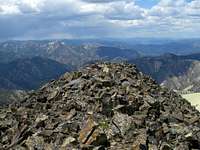
![White Mountain s Summit]() The Summit of White Mountain
The Summit of White Mountain When I got to the end of the rock band and faced snow again I was able to kick steps into the snow and use my hand for extra protection. It worked and I was over the snow quickly although my hands were quite cold. From there I followed an easy notch to the summit ridge and walked to the top!
The view from the top was amazing! I could see everything from the Beaverheads to the Sawtooths! Castle Peak and Mt. Borah were among the most prominent peaks I could see. The view into the Frank Church Wilderness was both colorful and amazing. I sat on the summit for only a few minutes as there were some rather dark and ominous clouds approaching from the North and West. My Dad radioed me and told me I had better hurry back to avoid the approaching storm.
![South Twin from White Mountain]() South Twin from White Mountain
South Twin from White Mountain
The descent went smoothly except for the fact I was trying to outrun a storm and not get hit by lightning. The sky grew darker and darker as I tried to stay out of the open and as far into the trees as I could. I saw flashes of lightning and heard thunder rumbling. A few drops of rain fell but nothing more. I was lucky because the storm went around the area and missed me completely.
As I neared the starting point where our vehicle was parked I suddenly noticed that I was extremely hungry. Every step I took seemed to be slower and heavier than the last. The truck looked so far away and I thought I would die before I got there. Finally I arrived! I took off my pack and devoured some roast beef sandwiches. Although they were nothing but beef, cheese, and mayo they tasted liked gourmet to me.
My Dad had come down from the summit of South Twin and told me it was a nice walk up the road to the top. He had talked with the ranger stationed there for a while, took in the view and headed down the mountain to meet me when I got back.
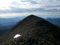
South Twin
After resting for a bit and filling my pockets with snacks I decided to walk up the road and knock off South Twin. I left my pack in the truck and headed off munching smoked almonds along the way. This was a very enjoyable walk. The views were amazing in every direction and walking on the road was a relief after a tough scramble on White Mountain. Without the road the mountain would be a challenging climb on loose talus. I reached the summit in about 15 minutes from the point where we were parked on the road. In addition to the lookout on the summit there is a helipad and a sign telling about the lookout. The view from the top is absolutely stunning, especially the view of White Mountain to the South. Looking at
North Twin I felt that it would be an easy climb but it would have to wait for tomorrow. After a few minutes on the top I headed back down the road with a sense of accomplishment, knowing I had just knocked off a difficult peak and added another 10,000 footer as a bonus.
![North Twin from South Twin]() North Twin from South Twin
North Twin from South Twin
I met my Dad back at the vehicle and we headed down the narrow road. Our plan was to camp at Sleeping Deer that night so when we reached the junction we turned to the West and continued up the road and into the wilderness.
Sleeping Deer Snow and a Gorgeous Sunset
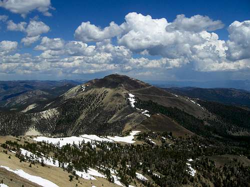
![South Twin and White Mountain]() South Twin and White Mountain from Sleeping Deer Road.
South Twin and White Mountain from Sleeping Deer Road.This section of the wilderness burned recently so all that was left were dead black snags. The undergrowth had not yet even grown back to cover the yellowish-white soil. The farther we progressed up the road the better the road became. The one disadvantage of Sleeping Deer Road is that it is only wide enough for one car at a time and there are very few places to pull off or turn around. We traveled about 5 miles down the road and towards a high ridge, all the while hoping we wouldn’t meet anyone coming the other way. We didn’t meet anyone but we did run into a problem in the form of a large snow bank covering the road. Blackened by the ash around it, this drift was about 6-7 ft. high and about 20 ft. wide. There was no way to go around it and no where to turn around! We were driving a Suburban too! (They aren’t known for being small and maneuverable.) The only thing we could do was back down the road and look for somewhere to turn around. I got out to guide my Dad and we continued down the road this way for about a mile. Soon I heard the sound of another engine and looked back to see a truck with Bannock County license plate coming up the road. I walked over to talk to them once they saw us and told them about the snow bank ahead. Soon we were both backing down the narrow road looking for somewhere to turn around. After about another mile we found a suitable place and turned around heading for Twin Peaks pass again. We noticed a good camping spot right at the summit and decided we stay there. Being between North and South Twin it was ideally situated for my planned climb up North Twin the next morning.
We got settled into camp and started making dinner when we realized we had used up most of our water that day. We weren’t near any streams or lakes but luckily there were a few snow banks around. We grabbed some snow and melted it in a pot for the next day’s water supply. That taken care of we had a feast of hamburger helper and canned peaches that really hit the spot. By now I was pretty stiff and sore from all the climbing I’d done in the past two days but with only North Twin left I felt like I had enough left in me to conquer one last summit.
After dinner we made a fire in the ring and sat around it enjoying its cheerful warmth and light. As we talked around the fire we were treated to one of the most amazing sunsets I have ever seen. The clouds in the sky glowed red-orange like the flames in our fire, bathing the entire landscape with the light of the setting sun. Across the pass the whitish rock of South Twin changed to glowing pink in the light. It was truly one of the most enjoyable evenings I can remember. It had everything; good food, great views, and best of all the company of my Dad. The evening would have been perfect had it not been for once hitch later on that night…..
![Frank Church Sunset]() One of my shots of the Sunset
One of my shots of the Sunset![Frank Church Sunset 2]() Another of my shots of the Sunset
Another of my shots of the Sunset![Sunset on South Twin]() Alpenglow on South Twin
Alpenglow on South TwinThe Hitch
When the sun set we stayed around the campfire until we ran out of wood. We put it out and looked at the stars for a minute. Then it was time to get ready for bed. Up until this time I felt fine but now I started to feel as though I was having heartburn. I thought nothing of it as it wasn’t too severe yet and went to bed. After a few hours of tossing and turning I woke up sweating and feeling like my stomach was on fire. It was either severe heartburn or I had swallowed a live coal from the campfire! I finally mustered enough strength to get up and get some antacid from the Suburban but just as I found it an incredible sense of nausea overcame me and sent me scrambling for the nearest tree where I threw up. (I found that I actually had swallowed a live coal!....Ok just kidding!) I never knew if it actually was heartburn, or indigestion, or whatever, but I sure felt better afterwards. I went back to sleep and slept soundly the rest of the night.
North Twin-Going Home
The next morning I woke up feeling great and ready for a final peak. My Dad questioned my sanity as I left the tent but I assured him I felt good and could make it. He chose to stay in camp and catch up on some sleep so I went for North Twin alone.
![South Twin View]() South Twin from North Twin
South Twin from North Twin
Starting at our camp in the pass, I followed the ridge that led up to North Twin’s broad South face. The hiking was easy the entire way and after getting around some giant snow drifts I was above treeline on the rusty talus slopes near the summit. Here I could see two distinct summits which looked equal in height. I decided to climb both of them to make sure I go to the real summit.
![North Twin Summit]() North Twin's True Summit
North Twin's True SummitFirst I tackled the western summit and found that it was slightly lower than the eastern one. I made my way over to the true summit and found there was a third, lower summit to the East of it. I sat on top in the morning light and soaked in my last summit view of the trip. Finally I turned my back on this last peak and made my way down to camp where my Dad was waiting. The whole climb took less than 1 ½ hours.
We packed up, said goodbye to the Twin Peaks area, and headed back into Challis where we picked up my car and had two of the best Subway sandwiches man has ever created. (It seems that climbing makes real food exceptionally good no matter what it is.) It was then time for goodbye and the drive back to our own homes, mine in Boise and my Dad’s in Preston.
It seems that even though some great plans don’t come to fruition, good things can still happen. I’m sure I would have enjoyed my time at Copper Basin (see
Part I) but I would have missed out on Borah and the Salmon River Trio. It was a great trip that both my Dad and I will always remember.
![The Frank Church Wilderness]() The Frank Church Wilderness
The Frank Church Wilderness


Comments
Post a Comment