
|
|
Mountain/Rock |
|---|---|
|
|
44.59279°N / 114.47617°W |
|
|
Custer/Lemhi |
|
|
Hiking |
|
|
Summer, Fall |
|
|
10340 ft / 3152 m |
|
|
Overview
South Twin at 10,340 ft. is the second highest summit in the Salmon River Mountains of Idaho and sits between White Mountain (10,442 ft.), the highest peak in the range, and North Tiwn (10,196 ft.) another of the highest summits. When viewed from Challis, Idaho South Twin appears to be the highest of the three but this is only because of the angle it is viewed at. It really is only 98 ft. lower than White Mountain though.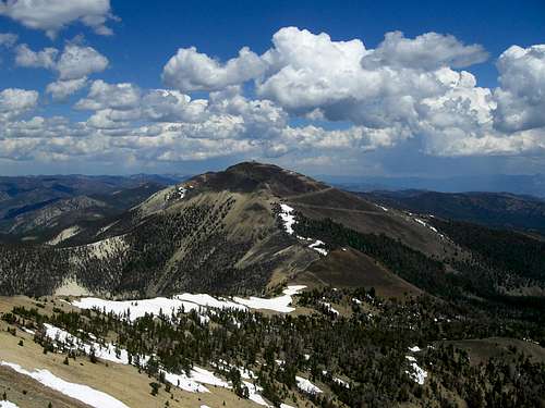 South Twin from White Mountain.
The peak is a loose pile of rust colored talus when viewed from the South. When seen from the North it shares the whiteish hue of its neighbor, White Mountain.
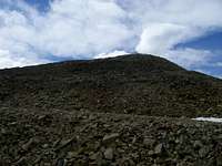 Talus
Talus 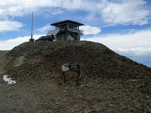 The Twin Peaks Fire Lookout.
 Alpenglow
Getting There
 The infamous guards.
 Map
MapThis is a very narrow road with room enough only to park or turn around at the switchbacks. There is no room for error as the drop-off on the downhill side can be pretty scary.
Depending on your vehicle you may wish to park where the road splits and walk up the road to the summit. If you’ve got a high clearance outfit you could continue up to the summit or at least to the first major switchback and walk the remaining 500 vertical ft. up the road.
 Lookout Road
Red Tape
Be aware that the lookout road is narrow and rough. While is 4WD is not essential it is a good idea. High clearance, though, is a must. Just pray you don't meet someone coming the other way. Amazing sunset from Twin Peaks pass.
Also be advised that the forest on West side of the Twin Peaks and White Mountain burned recently and can be subject to flash floods and other rapidly changing conditions.
Also, as with all wilderness areas, motorized travel is restricted in the Frank Church Wilderness. You shouldn’t need to worry about that though since you’re coming to climb. Remember, pack it in, pack it out.
No permits of any kind are required.
Weather

Camping
There are several good camping spots along Bear Creek. There is one established site with a table and fire ring near the cabins where the road splits. If you continue up the Sleeping Deer Road to the pass there is a large area established on the wilderness boundary suitable for camping. This area has several fire rings and a VERY primitive toilet.[img:527011:aligncenter:medium:Amazing sunset from Twin Peaks pass.]External Links
Salmon-Challis National ForestThe Idaho Outdoors Forum is where you can talk to others interested in Idaho's mountains.
This is the website for Tom Lopez'sIdaho: A Climbing Guide, the premier guide to Idaho's mountains.
Some info about the Frank Church-River of No Return Wilderness
Some info about the Twin Peaks Lookout.