
|
|
Route |
|---|---|
|
|
44.14020°N / 113.78933°W |
|
|
Mountaineering, Trad Climbing, Ice Climbing, Mixed |
|
|
Spring, Fall |
|
|
A long day |
|
|
5.7 (YDS) |
|
|
M3 WI3 |
|
|
III |
|
|
Overview
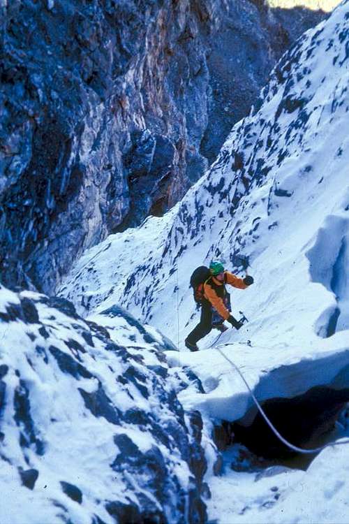
The route information on this page was provided to me by Kevin Hansen who has been gathering documentation on route history in Idaho's Lost River Range. Idaho climbers have long been known for not publishing climbs so I thank him for his effort in rounding up this information. The following route description and photos were provided by Tim Ball."We climbed up steep snow ramps to the horizontal band guarding the bottom of the slot. This pitch was a nasty death 5.7 lead (thanks Brad!). The slot above was soloed by all of us and had a crux narrows shoulder wide and short vertical step, WI3. We continued up the ridge for an hour or so till it got dark, then bum slid into the drainage towards Chicken-Out-Ridge, thence back around in the dark to the car at Rock Creek. This was in October of 2004 I think. There was 18" fresh unconsolidated snow on the approach and the entire basin was full of avy debris. Temps were chilly, minus ten rings a bell. We started about 4:00 AM, got back to the car around 10:00 PM. Quite the adventure. Doug and I returned two weeks later to climb PT but were storm bound and bailed".
Tim Ball 2014
Route Description
ROUTE NAME: Borah Borah Borah
DATE: Oct 2004
FA: Tim Ball (SMG), Brad Schilling (CIRO) Doug Colwell
RATING: (Grade III 5.7RX M3 WI3)
Route Description: Beginning at the base of the Psycho Therapy couloir, climb up and left (south) on steep 5.7RX snow ramps to the horizontal band guarding the bottom of the Borah Borah Borah slot.This slot can be soloed conditions permitting. The crux is a narrow shoulder wide and short vertical step, WI 3. Continue up the couloir to the top of the Northwest ridge.
Descent: From the top of the Northwest Ridge traverse downhill until you can glissade West down into Chicken Out ridge drainage, follow it northwest till it joins with Rock Creek. b) stay high on the Northwest ridge until you reach the summit, then hike down the COR trail. c) Scramble down the Northwest ridge and work your way back down to the saddle near point 10,789'.
 Borah Borah Borah Borah Borah Borah | 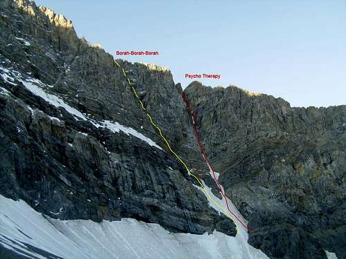 Borah Borah Borah Borah Borah Borah | 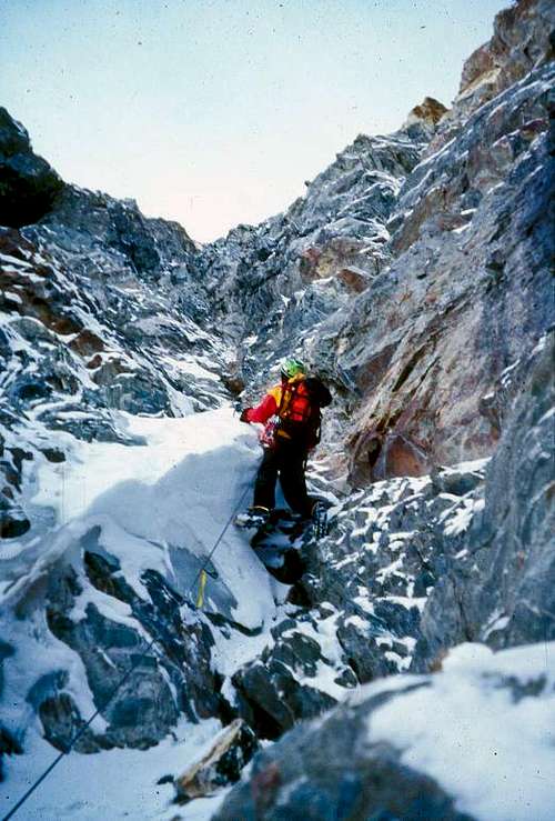 Borah Borah Borah Borah Borah Borah |
Essential Gear
Because the rock is a mix between Dolomite (the Jefferson Dolomite formation) and limestone, the rock fractures in small seams. Much of the protection you can find is half inch or smaller. A healthy selection of smaller wires, (Nuts) and as many small cams as you can find is recommend for most climbing on Mt Borah's steeper faces. Many placements are finger cracks and smaller. Leave the big stuff home. Narrow pins like bugs and knifeblades are useful on some of the seams. Bring a dozen slings to extend your placements and to loop around horns as well. No bolts have been placed on any of the alpine routes in the range but they would make a difference between sketchy and safe on many routes. Rockfall is a given in this range so a helmet is highly recommended and belays should be set with this in mind.Gear list for Psycho Therapy (provided by Kevin Hansen)
Gear to climb Psycho Therapy in May-June
A few gear placements present themselves in the sidewalls of the couloir. Typical of most rock climbing
in the Lost River Range, cam placements are very rare so camalots were not taken and never wished for.
5-8 bugaboo and knife blade pitons (yes, metal pins). Most placements are only good for 1-3 inches deep.
2 sets of wire nuts (most placements are finger width or smaller).
6 ice screws (10 cm - 16 cm more 10's and 13's than 16's).
Gear for Psycho Therapy in October-November
More nuts,
1 set of 1-4 OP link cams,
Sticky rubber shoes, chalk, and change of clean underwear
Getting There
 Rock Creek Approach Rock Creek Approach | 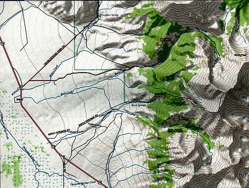 North Face of Mt Borah Approach Map North Face of Mt Borah Approach Map | 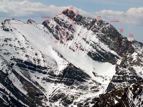 North Face of Mt Borah Route Photo North Face of Mt Borah Route Photo |
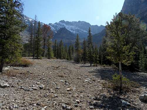
Mt Borah's north face cirque offers one of the easier approaches in the Lost River range both in driving and hiking time. The standard approach is from Rock Creek on the western side of the range (Highway 93). The turn-off to Rock Creek is a short distance up the Double Spring road about a mile north of the standard Mt Borah trail head turn-off.
Here's my suggestion for the easiest hike in to the face when Rock Creek is low enough to cross without difficulty. The road to Rock Creek is well described so I'll start at the upper parking spot above the small diversion dam. Park where the road makes a sharp bend and starts climbing a very steep hill (this is a hill that you do not want to drive). You will be on the left side of Rock Creek at this point. From here, folks tend to drop down to the dam and muck around in the Aspen looking for the creek crossing and trail. Instead, follow the contour (game trail) a short distance along the bare south-facing side of the canyon until you meet Rock Creek. Cross Rock Creek and then stay on the right side of the creek following a light boot trail up the canyon. A short ways up you will cross the debris from the west face drainage. The boot trail disappears from time-to-time in the scree and on the benches but if you keep your eyes open it is fairly easy to follow. The old (and much rumored) single track road that used to run up the canyon has either eroded away or is now covered with mature trees so don't bother looking for it. When the right side of the canyon starts to steepen, cross Rock Creek and stay on the left side of the canyon until it's obvious that you can go back to the right side of the canyon. The trail traverses the fairly steep (right) side of the canyon and soon climbs to more open ground where you will get a spectacular view of the mountain. Keep your ear on Rock Creek because around the three-mile mark it disappears underground and you may not see water again until you get to the cliff band at 9800'. Be aware that during the dry season or when the face is frozen up this may be the last place to find running water.If this sounds confusing, I'll break it down. Here's where you want to be: (mileage is approximate, total mileage to bottom of NF = +-5 miles)Left side of canyon - .25 miRight side of canyon - 1.75 miLeft side of canyon - .25 miRight side of canyon - .75 mi
At this point you should be close to where Rock Creek goes underground and the huge cirque above becomes visible. Climb another mile or so through the trees or follow the dry bottom of Rock Creek to the cliff band that blocks access to the moraine above. If dry, the cliff band can be climbed by way of the secret passage - the narrow Class 2 gully on the left or on the 3rd class+ steps just to the right of the gully. Directly above the cliff band there is a great biv site (when dry). It includes a big rectangular rock with a number of good boulder problems. Drinking water may not be available at this site during certain times of the year. When it's wet, it's best to avoid the drainages altogether, they are delicate and can flood very rapidly on this side of the mountain.
If this approach sounds too confusing then just stay on the right side of Rock Creek for the entire approach by climbing the ascending benches up the canyon. It is a steeper climb, holds snow later and leads to cliffs if you stray too high or low. It is also possible to drop directly into the cirque from the left spur on the Northwest Ridge but this involves some 4th and 5th class climbing on the Mike Howard Traverse.
Red Tape
None at all but it's probably a good idea to let someone know exactly where you are going.
External Links
The Joe T. Fallini (formerly Mackay Reservoir Recreation Site)
is the only recreational site in Challis that offers full RV hookups and
features a diversity of other facilities.
Tom Lopez: Idaho - A Climbing Guide