


-
 13390 Hits
-
 91.7% Score
-
 36 Votes
|
|
Route |
|---|---|
|
|
44.13707°N / 113.7807°W |
|
|
Mountaineering, Trad Climbing |
|
|
Summer, Fall |
|
|
A long day |
|
|
5.9 (YDS) |
|
|
III |
|
|
Overview
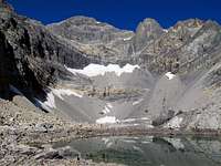 East Face of Mt Borah
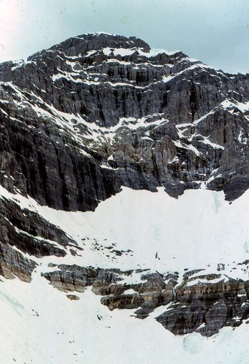 June, 1974
Timing during the year is crucial for success. In the past teams had been stormed off and serious rock fall prohibited any upward progress. Up until the early 90s the face held more year-round snow and ice as can be seen in the photos that are posted here. Prolonged drought beginning in the late 70s and a warming climate has resulted in this face being left mostly bare of snow and ice during Idaho's hot, dry summers of recent. The face is now a very quiet place compared to the near past. A geological survey of glaciers in the West confirms this: Glaciers of Idaho
The approach is not in any way straight forward. The Pahsimeroi Valley to the east of the Lost River Range is a complex network of back roads, jeep trails and four-wheeler paths. Finding the right drive in is tricky (good luck in the dark) and high clearance four-wheel drive vehicles are mandatory.
Because it is so remote and other faces take the spot light, the East Face has remained hidden and overlooked for many decades. Don't be fooled, this is one of the best gems in the gem state. During the summers of 2011 and 2012 three new routes have been put up on the face: East Face Routes
![Pahsimeroi River Access Map]() Access Map
Access Map![The Pahsimeroi Valley]() Pahsimeroi Valley
Pahsimeroi Valley![Pahsimeroi River]() East/West Fork Junction
East/West Fork Junction![Pahsimeroi River Approach]() Warning SignFrom Mackay, Idaho take Highway 93 north for approximately 22 miles (2 miles north of the Mt Borah access road) and turn right on the Doublespring Pass road (Forest Service Road 116). Follow the "improved" dirt road for about 7 miles to the summit of Doublespring Pass and then drive another 3 miles to the junction of Forest Service Road 117 on the right. The road takes off up a hard switchback and here the real adventure begins. There used to be a sign that indicated Horse Heaven Pass but I don't know if it's still there. Signs have a way of attracting bullets (just like cow pies and flies) in this country. Follow this road for about 1.25 miles to the first junction and take the right hand fork to Horse Heaven Pass. From Horse Heaven Pass drive another 2 miles to the next junction where again you turn right. Continue on Forest Service Road 116 for another 7 miles to the junction of the East Fork and West Fork of the Pahsimeroi River. Follow the West Fork junction to where the road ends at the unimproved campsite. I found it easier to start up the hill a little north of the parking spot to avoid the brush below the timber. As you gain elevation look for the narrow ridge that separates the Sacajawea and East Face cirques for the easiest way through the timber.
NOTE:
Warning SignFrom Mackay, Idaho take Highway 93 north for approximately 22 miles (2 miles north of the Mt Borah access road) and turn right on the Doublespring Pass road (Forest Service Road 116). Follow the "improved" dirt road for about 7 miles to the summit of Doublespring Pass and then drive another 3 miles to the junction of Forest Service Road 117 on the right. The road takes off up a hard switchback and here the real adventure begins. There used to be a sign that indicated Horse Heaven Pass but I don't know if it's still there. Signs have a way of attracting bullets (just like cow pies and flies) in this country. Follow this road for about 1.25 miles to the first junction and take the right hand fork to Horse Heaven Pass. From Horse Heaven Pass drive another 2 miles to the next junction where again you turn right. Continue on Forest Service Road 116 for another 7 miles to the junction of the East Fork and West Fork of the Pahsimeroi River. Follow the West Fork junction to where the road ends at the unimproved campsite. I found it easier to start up the hill a little north of the parking spot to avoid the brush below the timber. As you gain elevation look for the narrow ridge that separates the Sacajawea and East Face cirques for the easiest way through the timber.
NOTE:
![Sacajawea Peak]() Upper Saddle
Upper Saddle![Mt Borah s South Face]() South Face Descent RouteWalk off the southwest Chicken-Out-Ridge with all the masses of folks or descend down the south face that joins Sacajawea to (Chicken-Out ridge). Do not descend all the way to COR, that’s too far. If you plan on doing this route in one day (very possible) bring a head lamp. See Wes Collins' "The Exit" on his Dirty Traverse page for more details of this descent.
Having left our camp at the end of the road on the West Fork of the Pahsimeroi River, we descended the steep and very loose class III/IV South Face of Mt Borah into the Sacajawea drainage as mentioned above. We descended to the upper saddle by way of the standard route and then turned down the face just below the cliff band. We wisely avoided the gully (left of center) and zig-zagged down the face to avoid the cliff bands.
South Face Descent RouteWalk off the southwest Chicken-Out-Ridge with all the masses of folks or descend down the south face that joins Sacajawea to (Chicken-Out ridge). Do not descend all the way to COR, that’s too far. If you plan on doing this route in one day (very possible) bring a head lamp. See Wes Collins' "The Exit" on his Dirty Traverse page for more details of this descent.
Having left our camp at the end of the road on the West Fork of the Pahsimeroi River, we descended the steep and very loose class III/IV South Face of Mt Borah into the Sacajawea drainage as mentioned above. We descended to the upper saddle by way of the standard route and then turned down the face just below the cliff band. We wisely avoided the gully (left of center) and zig-zagged down the face to avoid the cliff bands.
Geology
Idaho’s Lost River Range is an actively uplifting fault-block at the northern end of the Basin and Range province. Extensional faulting has lifted the range relative to the down-dropped Big Lost River basin on its west side, producing steep ridges and slopes essentially devoid of foothills. Interior and eastern regions of the range are deeply incised by the Pahsimeroi and Little Lost Rivers. Most of the range, particularly in the central and southern regions, consists of thick layers of Paleozoic limestone and dolomite. Multiple episodes of tectonic deformation have resulted in dramatic open to isoclinal folding at a scale of meters to kilometers. Glaciation has carved numerous cirques throughout the range and alpine lake basins are scattered in the central and eastern portions. These combined activities have created an impressive assortment of large, high angled faces with western, northern, and eastern aspects.Getting There
 Access Map
 Pahsimeroi Valley
 East/West Fork Junction
 Warning Sign
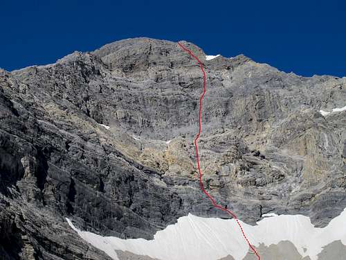
Come well prepared and plan for self-sufficient travel in this remote country. Cell phones and satellite phones may not be reliable in some locations and there can be long distances between good water sources in the late season. 2-ply sidewalls and tubeless tires might not survive this trip and make sure your spare is full-sized, inflated and you know where the jack is and how to use it. Don't forget your lug wrench. If you break down in this country or get snowed in you may have to walk out. Search and rescue in this range can be very difficult, expensive and a real burden on the local law enforcement and Forest Service staffs who are the first to be called for emergencies in this area.![East Face Direct - Route Photo]() Route PhotoStart at the highest glacial lake in the East cirque and walk around the north side of the lake for easiest access. Angle your way around the bottom snow field and trudge your way up the scree until you reach the first rock band. This is an easy class 2-3 scramble for 20 meters or so. Once on top, pick your path of least suffering up the scree to the bottom of the snowfield. Depending on where you choose, this class 2 scree slope is not friendly. Loose dirt and gravel are stacked at a 50 degree angle for a few hundred feet. Once at the toe of the snow field, find a place to strap on your spikes. The slope is around 45 degrees and it is wise to bring crampons. Depending on snow conditions, an alpine ice axe could help. Hop the randkluft and get onto the face. At first sight it looks like 80 percent of the East Face is 5.6 to 5.7 climbing which is a good rating for the first 4-5 pitches. East Face Direct follows a dark water streak that passes just left of the top of the "Super S" as Kevin called it. The "Super S" is a large obvious fold in the rock strata that composes the lower right quarter of the East Face. At any time, a team could climb side ways (off route) to the right or left a few hundred feet to avoid the more difficult sections. The direct route stays plumb with the top, following the dark water streak to find the best rock. Because most of the climbing is 5.6 - 5.7, groups may choose to simul-climb many of the pitches. Teams that wish to set up a solid anchor every rope length could discover the route is close to 9-10 pitches. As with all mountaineering, speed is safety. Several class 2-3 scree slopes divide the rock pitches. One short pitch was a solid 5.9 with a protectionless, small overhang. It's the finest part of the route. Once past the final head wall, put the rope away and enjoy the last 300 feet of class 2-3 scrambling to the summit.
Route PhotoStart at the highest glacial lake in the East cirque and walk around the north side of the lake for easiest access. Angle your way around the bottom snow field and trudge your way up the scree until you reach the first rock band. This is an easy class 2-3 scramble for 20 meters or so. Once on top, pick your path of least suffering up the scree to the bottom of the snowfield. Depending on where you choose, this class 2 scree slope is not friendly. Loose dirt and gravel are stacked at a 50 degree angle for a few hundred feet. Once at the toe of the snow field, find a place to strap on your spikes. The slope is around 45 degrees and it is wise to bring crampons. Depending on snow conditions, an alpine ice axe could help. Hop the randkluft and get onto the face. At first sight it looks like 80 percent of the East Face is 5.6 to 5.7 climbing which is a good rating for the first 4-5 pitches. East Face Direct follows a dark water streak that passes just left of the top of the "Super S" as Kevin called it. The "Super S" is a large obvious fold in the rock strata that composes the lower right quarter of the East Face. At any time, a team could climb side ways (off route) to the right or left a few hundred feet to avoid the more difficult sections. The direct route stays plumb with the top, following the dark water streak to find the best rock. Because most of the climbing is 5.6 - 5.7, groups may choose to simul-climb many of the pitches. Teams that wish to set up a solid anchor every rope length could discover the route is close to 9-10 pitches. As with all mountaineering, speed is safety. Several class 2-3 scree slopes divide the rock pitches. One short pitch was a solid 5.9 with a protectionless, small overhang. It's the finest part of the route. Once past the final head wall, put the rope away and enjoy the last 300 feet of class 2-3 scrambling to the summit.
Route Description
 Route Photo
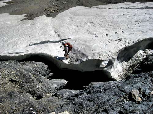 Kevin jumping the rand
 | 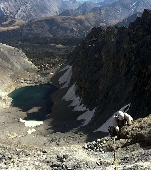 Kevin topping out on P1
 | 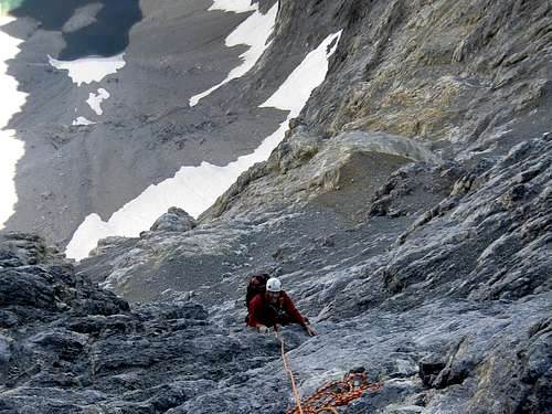 Wes nearing the Third Band
 | 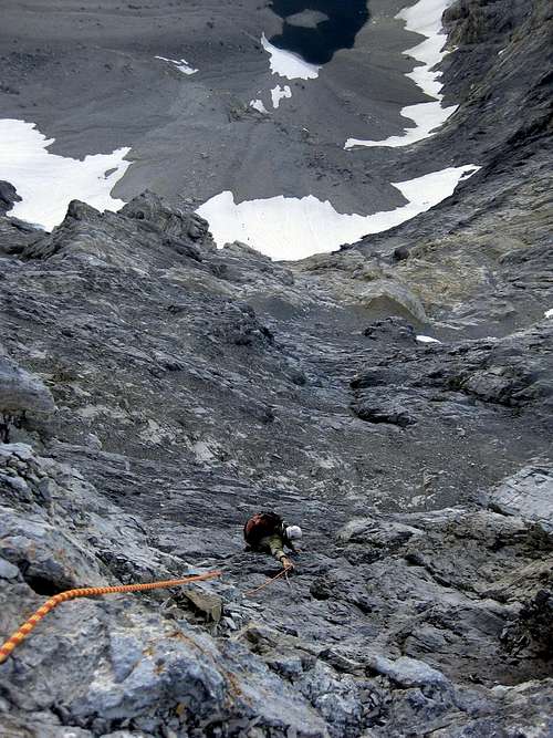 The top of P5
 | 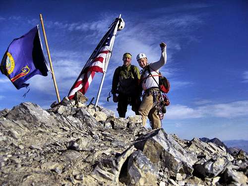 Wes and Kevin on the summit Wes and Kevin on the summit |
Descent
 Upper Saddle
 South Face Descent Route
Gear
Because the rock is a mix between Dolomite (the Jefferson Dolomite formation) and limestone, the rock fractures in small seams. Much of the protection you can find is half inch or smaller. A healthy selection of smaller wires, (Nuts) and as many small cams as you can find is recommend for most climbing on this face. Many placements were finger cracks and smaller. Leave the big stuff home. Bring a dozen slings to extend your placements and to loop around horns as well. Rockfall is a given in this range so a helmet is highly recommended.When to Climb
The safest time of year is late summer and mid-fall. Less snow on the upper slopes equates to less rock fall. Also, this is Idaho's most popular summit, seeing hundreds of hikers every weekend ascend via the Southwest ridge. Be aware they may throw stuff off the top at you.Side Note:
A large part of the experience on this side of the mountain is related to the spirit of adventure. For that reason, pitch-by-pitch beta was omitted. You don't need some computer screen to tell you what you can and can't do. Just grab a partner, some gear, and go for it! This route is similar to the CMC face on Moran, or Snake Dike on Half Dome. At the time of this writing, no bolts exist on Mount Borah, all anchors are built using traditional methods and gear. The climbing is awesome, the views are the best, and the experience is magic. 7-Day Weather Report - Web Cam
Red Tape
None at all but it's probably a good idea to let someone know exactly where you are going.
First ascent: Lyman Dye, Wayne Boyer 1962 East Face (II, 5.2)
Climb the face from the notch on the northeast ridge (between the summit and Point 12247). Climb to the notch from Rock Creek which is just to the north. The crux of the climb is the first 90-foot pitch out of the notch. The angle decreases and the holds improve above this pitch.During August, 2011 Wes Collins went up to the cirque for a recon and climbed the east face to the summit.This was the second ascent of the East Face of Mt Borah. See his Borah East - Trip Report/Route on the Idaho Summits forum.
On September 24, 2011 Wes Collins and Kevin Hansen made a third ascent of the East Face by way of the route described above.
Local Links - Accomodations
The Joe T. Fallini Campground (formerly Mackay Reservoir Recreation Site) is the only recreationalsite in Challis that offers full RV hookups and features a diversity of other facilities.