
|
|
Route |
|---|---|
|
|
44.13720°N / 113.7794°W |
|
|
Mountaineering |
|
|
Spring, Summer |
|
|
One to two days |
|
|
Class 4 |
|
|
Over View
Mt. Borah East RidgePage Photo by Idaho Summits
Warning: Traditional alpine mountaineering is an inherently dangerous sport!
(Is that what makes it so much fun)???
Getting There
 The Summit Block of Mt. Borah stands over the East Ridge, this photo was taken near the top of point 12,247'
Access the East Ridge via Rock Creek. The ridge approach is the same as the North Face Route
Turn off of U.S. Hwy 93 onto Double Springs Pass road 22 miles north of Mackay or, a little less than 2 miles north of the Borah trailhead road. Drive three tenths of a mile and turn east onto Rock Creek road, follow it 3.2 miles to where it ends at an irrigation dam in the mouth of the canyon.
 Mt. Borah photo taken from the summit of Mt. Corruption. The North East Ridge is on the right side of the summit block.
There are rumors about the existence of an old logging road that snakes its way several miles up the canyon and although there are signs of an old ‘small time’ logging operation, to find a road, you’ll need to spend some time with Ms. Cleo on the psychic hotline. Cross the creek at the dam and stay on the south side of the creek. Follow good game trails above the creek for most of the way.
Hike about 3 miles up the canyon and cross the creek when you are even with Mahogany creek pass, hike up onto the pass and you’ll be rewarded with a great view of Mahogany creek. The climb starts on the ridge to the south.
Route Description
 Summit block route
Ascend the mile long class 2 hike to point 11,715 from there to point 12,247’ is a class 3 scramble. Traverse the ½ mile ridge and avoid the worst of it by staying on the right side of the ridge, the south side is wildly over hung with bad rock. Now the only thing between you and the Summit block is a 120’ spur. Take a good look at the rest of the route from the point, there are several possibilities on the ridge and the right side of the ridge, memorize it if you plan to down climb it.
Cross the spur on it’s north side and you’re at the summit block and the crux of the route. If conditions are right, climb up the very exposed 70’ chimney on the right side of the ridge. If there is no snow or rotten snow you may have to down climb onto the north face and find an opening in the rotten cliff band that sinks off the ridge and drops several hundred feet down the North face. You would then have to climb back to the ridge through a maze of rock bands and snow slopes. follow the ridge over several “less demanding” moves to the final headwall and then up through a narrow “S” shaped couloir to the summit.
Note: An alternative to the “S” couloir would be to cross over the North Face route. I’ve done both and believe they are about sixes, the final 50’ of N.F Direct is a little steeper but the entire chute offers more options for picket placement and belay.
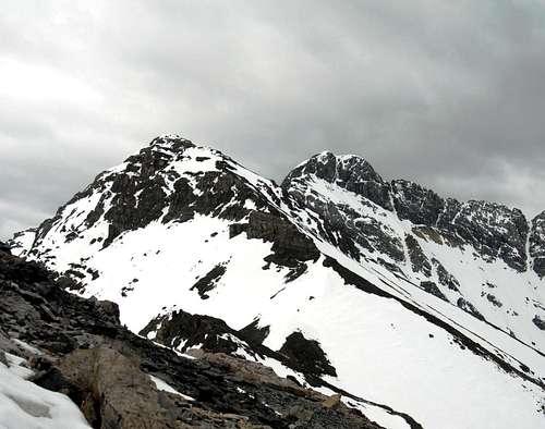 Point 12,247. When Viewed from the ridge, this one looks like a stand alone peak
 Looking down the North East Ridge, point 11,715' is in the center and shows the top of the ridge leading back to Rock Creek Peak 11,828 is on the far end.
Essential Gear and Notes
HELMET, axe, crampons, rope, two pickets + slings and binersThe East Ridge can be done as a traverse in one long day, climbers can pack light and descend the standard South West Ridge route if they have a vehicle parked at the trail head, or descend to the tree line and follow the canyon back to Rock Creek. (good map reading and route finding skills required). The benefits are, a much shorter hike and no tough down climb. For those who want a more leisurely pace It can be done as an overnighter. There are numerous tent placements near water with great views and an ‘off the map’ feel
External Links
Idaho Climbing GuideIdaho Summits.com
Lost River Ranger District