
-
 13386 Hits
-
 85.34% Score
-
 20 Votes
|
|
Mountain/Rock |
|---|---|
|
|
43.96190°N / 103.3982°W |
|
|
Pennington |
|
|
Hiking, Scrambling |
|
|
Spring, Summer, Fall, Winter |
|
|
5331 ft / 1625 m |
|
|
Overview
*Under Construction* Boulder Hill from the north
Boulder Hill is a surprisingly scrappy and rugged little peak in the eastern Black Hills near Rapid City, South Dakota. The peak is a splendid example of the surprising beauty of the Black Hills. The 10 or so minutes of scrambling at the top of the hill came to me as a very pleasant surprise. The summit area is characterized by two highpoints: A lower, southern highpoint with the ruins of an old lookout on top from which broad views can be enjoyed, and a smaller, northern true highpoint which includes the USGS marker.
The views from the top of this peak are mostly open and quite nice! Rolling hills are all around. Parts of Rapid City can be seen in the distance to the northeast and Harney Peak dominates the horizon to the southwest. The easiest route to the summit is a Class 2+ jaunt through and over boulders and up ramps, and this is a good introduction to scrambling for beginners or kids.
Rank: 124th highest peak in South Dakota
Prominence: 391 feet
USGS Quad: Mount Rushmore
Recreation Map: Trails Illustrated #751 | Black Hills North
Rank & Prominence: Lists of John
Getting There
 Wild Iris
 Rocky Terrain
Boulder Hill is just a few road miles out of Rockerville, South Dakota. Rockerville is approximately 15 minutes southwest from Rapid City and can be reached by travelling roughly 13 miles westbound on US 16. Boulder Hill is also readily accessible by visitors to Hill City, a popular Black Hills tourist town. The mountain is snuggled between US 16 to the south, US 385 to the west and County 228 / FS 433 to the north.
 Ruins of old lookout Ruins of old lookout |  Southeast down the ridge Southeast down the ridge |  USGS Marker USGS Marker |
Red Tape
 Views to the northeast
 Harney Peak dominates
| Generally, there is relatively little red tape in this area. There is no fee to visit this part of the Black Hills National Forest and permits are not required for parking or foot travel. Please follow LNT (Leave No Trace) principals: 1. Plan Ahead and Prepare 2. Travel and Camp on Durable Surfaces 3. Dispose of Waste Properly 4. Leave What You Find 5. Minimize Campfire Impacts 6. Respect Wildlife 7. Be Considerate of Other Visitors |
Camping
 Along the ledge system
 Beautiful ledge system
The nearest camping is in the Sheridan Lake complex (elevation 4,624 feet).
Sheridan Lake South Short Campground
• Open year-round
• $21/night
• 126 sites
• Grills, tables & vault toilets
Visit the Black Hills National Forest Website for Sheridan Lake Campsite for more information.
 Toward Rapid City Toward Rapid City |  Harney Peak to the Southwest Harney Peak to the Southwest |  Summit Views Summit Views |
Weather & Seasons


Panoramic Views
 Views over boulders to Harney Peak
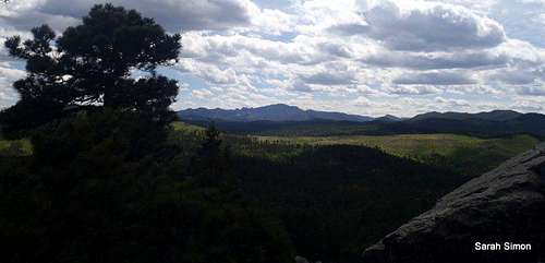 Harney Peak dominates the southwestern skyline
 Mountains, mountains everywhere!