
-
 28996 Hits
-
 84.82% Score
-
 19 Votes
|
|
Mountain/Rock |
|---|---|
|
|
44.24446°N / 103.73518°W |
|
|
Lawrence |
|
|
6804 ft / 2074 m |
|
|
Overview

Custer Peak Fire Lookout Tower
Custer Peak is one of the more prominent peaks in the north central area of South Dakota’s Black Hills. Located about 7 miles south of the Deadwood-Lead area, the peak was named for General George Armstrong Custer, who explored this area in 1874. Though the mountain was named for him, his group did not make any attempt to climb the peak.
The fire lookout tower at the summit was constructed 1937-1938 and is still used, though generally only during fire seasons. It is now on the National Historic Lookout Register. There are several other small buildings at the summit, plus some ruins of earlier structures. The views from the summit are clear and pretty much unobstructed. Perhaps the easiest summits to identify from Custer Peak would be Harney Peak to the south-southeast, Bear Butte to the northeast, and Terry Peak to the north.
In 1893, the peak was used for a USGS triangulation station, along with Harney Peak near the town of Custer, and Bear Butte near Sturgis. In 1925, a USGS brass cap on a pipe was placed at the summit. Today, there are three markers, all near the tower.
Getting There & Route
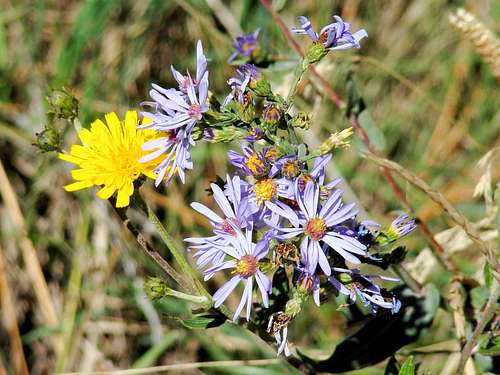
Custer Peak Wildflowers

Clear skies on a beautiful winter day at Custer Peak.
Custer Peak is usually accessed from Highway 385. About 7 miles south of the Deadwood-Lead area, turn west on Forest Road 216.1. Just over 2 miles west from the highway, you will find Forest Road 216.2. Here, you can choose to hike or 4-wheel the rest of the way. Turn there (north) and follow the road to Forest Road 216.2A (about 1 mile).
There is also another road that goes east from that intersection. It is Snowmobile Trail 7. If you are 4-wheeling, at this point you may have to park and hike the rest of the way to the summit. The forest service sometimes has the road closed from that point. If it is in an “extreme fire danger” period, all further access to the summit may be closed until further notice. So you will want to be sure to call ahead. The Forest Service Office in Custer should be able to give you the latest information.
The forest service office number is (605) 673-9200.
Route: The final stretch to the summit is less than 1 mile. I would not recommend trying to drive this section, as it seems to be for ranger use only. It is very narrow and there are no intersections, meaning that if anyone encounters a forest service vehicle coming down, it would be a very difficult process backing down a long way. Eventually you will come to a very small parking lot. The last segment goes up the ranger parking space, then turns into a rocky trail to the fire lookout tower.
Maps
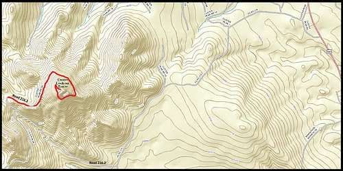 Custer Peak Route
Custer Peak map details are shown on the Minnesota Ridge USGS Quad Map. A great map for this area is the National Geographic Black Hills North map. Also quite helpful is the free "Bearlodge and Northern Hills Ranger District" Motor Vehicle Use Map.
Red Tape

The upper trail on Custer Peak, near the summit

A Watchful Bird on Custer Peak
This is public land with no access fees (yet). But, forest fires in this region are serious concerns and the “no access” rules are enforced during “extreme fire danger” periods.
There are also vehicle restrictions from the junction of Forest Roads 216.1 & 216.2. Only small to medium-sized 4-wheel drive vehicles are allowed from that point. Road 216.2A gets quite narrow, so if you are actually trying to drive that section, please be prepared for some long backing if you encounter a forest service jeep or another vehicle.
When to Climb
This is all public land, so the summit is normally opened year-around. But heavy winter snow could mean you might need to snowshoe to the summit. During times of serious drought and frequent forest fires, the access to the summit is closed. Summer lightning can also be a deterrent to a hike. For the latest weather for the area, click here:
Custer Peak - Lead, South Dakota Weather
Camping Resources

An old abandoned cabin by Custer Peak
There is a wealth of public and private campgrounds and lodging facilities in this area – too much to list here individually. For up-to-date information, check out the websites below for details on what is available:
National Forest Campgrounds
Deadwood Chamber of Commerce
Black Hills Campgrounds.com