
-
 20026 Hits
-
 81.18% Score
-
 13 Votes
|
|
Mountain/Rock |
|---|---|
|
|
43.92350°N / 103.7542°W |
|
|
Download GPX » View Route on Map |
|
|
Pennington |
|
|
Hiking |
|
|
Spring, Summer, Fall |
|
|
7210 ft / 2198 m |
|
|
Overview
 Summit Shooting Star
Harney Peak, the highpoint of South Dakota, rises rugged, bold and bulky above its surroundings. One may expect the same of the second highest peak in South Dakota, a bit of an encore, and can be forgiven for being…a bit underwhelmed by Odakota Mountain. The summit of Odakota Mountain is wooded by slender pine trees and the views are limited. A dirt road traverses high above the western slopes of the mountain, making the mountain extremely accessible. And even with nearly 1,500 feet of vertical prominence, the mountain rises gently out of its surroundings. Odakota Mountain is a peakhunter’s mountain, to be sure, but this can force the visitor to slow down and enjoy the small things, like tiny wildflowers dotting the ground cover in the spring or the first cool breezes of fall.
Rank: 2nd highest peak in South Dakota
Prominence: 1,350 feet
USGS Quad: Ditch Creek
Planning Maps: Trails Illustrated #751 Black Hills North & #238 Black Hills South
Rank & Prominence: Lists of John
Getting There & Route Overview
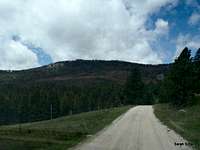 |  |  |
Odakota Mountain is approximately 14 road miles from Custer, South Dakota. Have good planning map or Gazatteer to locate this trailhead. This trailhead should be accessible to most passenger vehicles in dry conditions. The roads are graded and well-maintained.
Driving directions from Hwy 385 northbound out of Custer…
• Head west/northwest on CR 297, passing the Boy Scout camp, for several miles to FS 299.
• Turn left at the fork in the road onto FS 299 (Bobcat Road).
• Bobcat Road (FS 299) will dead-end at FS 301 (Sixmile Draw). Turn left.
• Travel only a short while westbound on FS 301, then turn left on the more rugged FS 693.
• Park at high point of FS 693 (west of the summit of Odakota Mountain).
Walking directions from parking…
From here, the summit is ¼ mile almost due-east of the parking area, requiring less than 80 feet of elevation gain. The worst objective hazards are deadfall and ticks. The summit is on a small outcrop surrounded by low cliffs, and marked by a small cairn of white rock. If you feel the need for more challenge, you can always park further away and walk dirt roads for additional mileage and elevation gain. Or, perhaps park on FS 1E and bushwhack up the southeastern slopes!
Roundtrip Distance: ½ mile
Elevation Gain: 80 feet
YDS Class: 2
 |  |  |  |
Red Tape
 Looking to the southeast
 Shooting Star
| Generally, there is relatively little red tape in this area. There is no fee to visit this part of the Black Hills National Forest and permits are not required for parking or foot travel. Please follow LNT (Leave No Trace) principals: 1. Plan Ahead and Prepare 2. Travel and Camp on Durable Surfaces 3. Dispose of Waste Properly 4. Leave What You Find 5. Minimize Campfire Impacts 6. Respect Wildlife 7. Be Considerate of Other Visitors |
Camping & Lodging
 Signing the summit register
Rustic Camping
A nearly unlimited supply of rustic backroads camping is available on a first come, first served basis on Forest Service roads near Odakota Mountain. Haul your own water and pack out what you pack in.
Designated US Forest Service Camping
The US Forest Service operates three campgrounds (Custer Trail Campground, Dutchman Campground and Whitetail Campground) at the nearby Deerfield Reservoir, 20 miles west of Hill City, South Dakota. This USFS page provides more detail.
Custer & Hill City
The nearby towns of Custer & Hill City provide a wide range of lodging options, from Mom & Pop campgrounds and simple motor lodges to chain hotels and upscale vacation homes.
 Summit jar Summit jar |  Register entries Register entries |
Weather & Seasons


 Register entries Register entries | 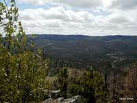 Register entries Register entries |  Register entries Register entries |