
-
 13797 Hits
-
 81.84% Score
-
 14 Votes
|
|
Mountain/Rock |
|---|---|
|
|
42.67500°N / 110.6167°W |
|
|
Hiking |
|
|
Summer |
|
|
10980 ft / 3347 m |
|
|
Overview
Box Canyon serves up a spectacular, moderately strenuous, little-known day hike into the heart and the crest of the glorious and underappreciated Wyoming Range. From where the trail tops out at its intersection with the Wyoming Range Trail, there is easy access to lofty, flat-topped summits that provide secluded, top-of-the-world views of Wyoming’s quietest alpine wilderness and its greatest mountains, including Gannett Peak (the highest) and the Grand Teton (the most famous). All the while, you may be scratching your head as you wonder whether you’re in the Northern Rockies or in Utah. You’re in Wyoming, but you get a bit of what’s best in both of those awesome states out here-- clear, rushing streams and waterfalls; soaring red cliffs; snow-streaked summits; big game; rugged wilderness that has an otherworldly, undiscovered feel about it.Getting There
Drive south from Alpine, Wyoming on the wonderful Greys River Road (please see the section for it on this canyon’s parent page) for 47.5 miles. Driving south, there are two things to watch for: a large burned area that features sweeping views (to the east) of the Wyoming Range, and the Corral Creek Guard Station (on the right-- west-- side of the road). When you reach the burned area, you are just minutes away from the trailhead, which is less than two miles from the Corral Creek Guard Station. Look for a sign indicating Box Canyon Creek (most creek intersections along this road are signed), and then look for a parking area on the left (east) side of the road. This is the trailhead. I can’t imagine that the parking area would ever be full, but just in case it is, parking spots along the Greys River Road just before or after the trailhead parking area are easy to find.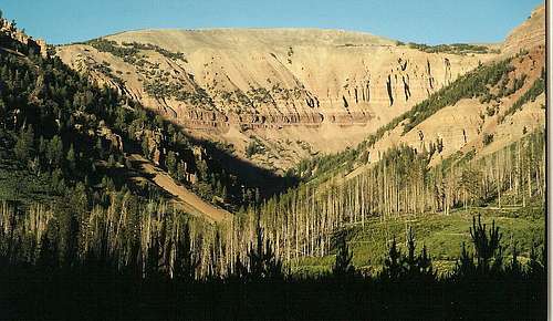
Looking up Box Canyon from the trailhead
You can also approach the Greys River Road via Tri-Basin Divide from U.S. 89, to the west, or from La Barge, to the east. From the divide, it is about 15-18 miles, much of it through gorgeous meadows, to Box Canyon Creek.
Route and Gear Information
RouteThe trail through Box Canyon reaches the crest of the Wyoming Range at Box Canyon Pass and Lunch Creek Meadows, about 9600’ in altitude. The trail itself climbs 2000’ over four miles. Overall, that makes for only a moderately difficult grade, but beware that the first half of the trail does not gain that much elevation. The second part of the trail, where the route suddenly climbs precipitously from the canyon floor, is quite steep. Footing is good and views are excellent most of the time, but the trail crosses the stream near the top and can be slippery around there. Hikers are also likely to encounter snowbanks in the very upper reaches through early July at least. Water is never far away from the trail, and though the trail is sometimes too high above the creek to make access inconvenient, you never have to wait very long until water is closer.
The area around the trailhead burned back in the 1990s, and the first half-mile or so of the trail passes through charred trees and recovering mountainsides. Soon, though, the trail enters unscarred terrain, and breaks in the trees and occasional small meadows and talus slopes allow you to view the high cliffs enclosing the landscape here. The canyon isn’t narrow in the sense that southern Utah’s wilderness canyons often are, but the cliffs are high and steep enough to create the impression that the canyon is narrower than it really is.
2.5 miles and about 1000’ up from the trailhead, the trail crosses to the south side of the creek. Near a fork in the stream, an impressive waterfall, Box Canyon Falls, appears ahead and to the right. Viewing the falls up close requires a little bushwhacking, and the falls could make a nice stopping place for lunch or just a little break, but the trail actually bends left (north) and away from the falls before reaching them. The trail becomes somewhat faint in this area, and good maps and a good sense of direction are extremely helpful. Keep in mind that the trail runs roughly parallel to the right side of the left (north) fork of Box Canyon Creek.
South from the switchbacks
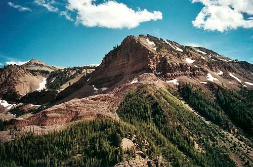
The next one-mile stretch is the trail’s steepest, gaining about 800’, and switchbacks climb in earnest up from the canyon floor and through a part of the canyon not visible from the trailhead (in fact, from the trailhead, Box Canyon seems to be dead-ended by a sheer mountain wall). This is easily the most scenic portion of the hike, and you can justify breath-catching pauses with the need to stop and admire the beautiful country all around you. Take time to appreciate the fact that such astonishingly pretty country is virtually unknown except to people who live in this area of Wyoming and in very eastern Idaho. Shortly after the switchbacks end and a steep grade continues and just past another waterfall, the trail crosses to the left side of the creek, and there are two more crossings before the trail tops out at Box Canyon Pass. The grade of the last half-mile abates somewhat but remains moderately steep until almost the very end, when the trail crosses some soggy, rolling meadows and reaches its junction with the Wyoming Range Trail, which runs north-south throughout the length of the range, at Box Canyon Pass (9600'). At the pass, enjoy the wide-open, rolling high country of the Wyoming Range, so contradictory to the rugged, imposing appearance of these mountains from below.
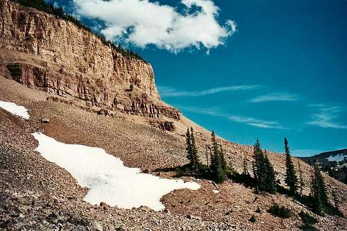
Near Box Canyon Creek Pass
There is a tiny lake at the pass, and it drains east through Lunch Creek Meadows and down the leeward side of the mountains. A trail descends with the creek. The area around the pass makes a wonderful place to camp, and a stroll of no more than two miles north or south along the Wyoming Range Trail will take you atop or near broad summits approaching 11,000’ in elevation. These unnamed mountaintops will yield unforgettable views of some unforgettable Wyoming mountain country.
To the north, hike a short distance along the trail to a 9850' and then strike west cross-country to reach a series of long, flat summits that top out just shy of 11,000'. These summits are walk-ups.
To the south, follow the trail for a steep mile to reach a series of summits over 10,600'. These, too, are walk-ups.
Gear
Good hiking boots; trekking poles may help with snowbanks and stream crossings in early summer.
Red Tape
No red tape, but be extremely cautious in this area (or avoid it altogether) during the fall hunting season.Make sure you have a good spare tire and that your vehicle is in good working order before you head out here. It is a very remote area, and help is almost certain to be far away, slow in coming, and unpleasantly expensive.
Camping
There are some developed campgrounds along the Greys River Road, but they do not have running water or flush toilets. Don’t count in toilet paper being available out in this remote country; bring your own.Far more enjoyable than staying at a campground, though, is dispersed camping out here. Actually, right across the road from the trailhead is a wonderful campsite, but there are virtually endless opportunities nearby. Remember to use only existing fire rings if you have to have a fire at all, and avoid fires during drought years (and there have been many over the past decade). Take notice of Forest Service signs that list restrictions or bans on campfires.
USGS Maps
Mount SchidlerBox Canyon Creek