
-
 6440 Hits
-
 86.37% Score
-
 22 Votes
|
|
Mountain/Rock |
|---|---|
|
|
42.59718°N / 110.62586°W |
|
|
Hiking |
|
|
Summer |
|
|
11220 ft / 3420 m |
|
|
Mt. March Madness is a locals’ name for Point 11,220, the next peak south from Wyoming Peak in the Wyoming Range. When I was looking for information on a nearby peak, search results produced a picture of Point 11,220, and that is how I learned of the name. I do not know where the name comes from, but I am pretty sure it doesn’t allude to the NCAA basketball tournament. My best guess is that it perhaps refers to exciting ski routes on the peak in late winter and early spring.
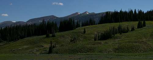
The peak is attractive from any angle, drops steeply on the east and the west, and has over 400’ of vertical rise from its south-side saddle, but the rise from its saddle with Wyoming Peak is only about 240’, meaning it will not appear on lists of ranked peaks. Nevertheless, it is more than a mere bump and is worth a visit (and a page). It also happens to be the third-highest peak in the range, behind Wyoming Peak (11,378’) and Mount Coffin (11,242’). Interestingly (or maybe not), all three peaks are together in a row, though the north-south order is Coffin-Wyoming-March Madness.
Anyone wanting to climb this peak should consider extending the outing to include Wyoming Peak, Mount Coffin, and Mt. March Madness. All three are close together.
The 11,220’ elevation is probably an interpolated one. At the summit, I did not see a benchmark, and the highest contour for the peak on the USGS Poison Meadows quad is 11,200’. Since the map has 40’ intervals, the summit elevation is probably just a guess based on half the rise between the 11,200’ and 11,240’ intervals. With my GPS device, I got a maximum elevation of 11,219’.
First-time visitors to this area will probably want to, and probably should, climb Wyoming Peak as well (only half a mile away, adding one mile RT to your day). Others may wish to skip Wyoming Peak this time around.
Route
From the trailhead at about 8720’, the Wyoming Peak Trail at first climbs steeply but then moderates as it follows a few long switchbacks to a saddle at almost 11,000’. In Thomas Turiano’s Select Peaks of Greater Yellowstone, the author says it is four miles to Wyoming Peak, but it is really four miles to this saddle, which is about half a mile south of Wyoming Peak. This saddle is between Wyoming Peak (north) and Mt. March Madness (south). Along the final approach to the saddle, Mt. March Madness is sometimes directly above you, and you could get there more directly by heading up the scree, but it is less tiring and only a little longer to go the saddle and then follow the easy ridge to the summit.

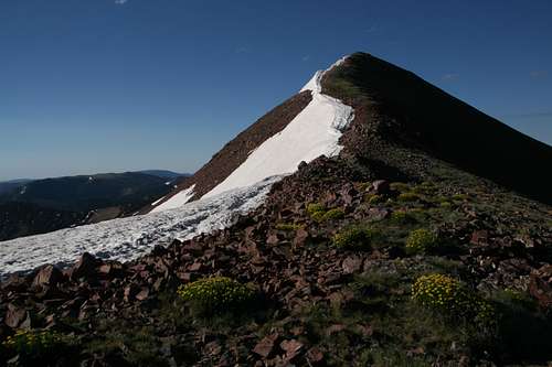
When you reach the saddle, from which the summit is both clearly visible and quite spectacular, just follow the ridge to the top. This is Class 2 hiking, and the slope is fairly gentle and the footing good. The distance from saddle to summit is only 0.4 mi.

The summit has nice views of the Salt River Range, Mount Coffin, Wyoming Peak, and the basin below the east faces of Wyoming and March Madness. Another interesting view is to the south, where the Wyoming Range ends and Commissary Ridge begins.

There is also a trail approach from the east. Maps show the trail reaching the north side of Wyoming Peak above the Coffin-Wyoming saddle and then climbing to the summit of Wyoming Peak. I have never gone that way, but I know the trailhead is higher by about 140’, the distance to the summit (of Wyoming Peak) is 6 miles as opposed to 4.5 (making your March Madness distance about 7 miles as opposed to 4.4, with additional elevation gain both ways), and that the trail can be hard to find and follow in places.

Getting There
From the north: Leave Alpine and drive south on the spectacular Greys River Road, a dusty, unpaved road suitable for most passenger cars, 54.7 miles (remember that odometers can vary slightly) to Shale Creek Road (FR 10126). I seem to recall a sign being there in 2004, but there was no sign in 2010. Well, there is a sign, but it is just a post with an arrow design on it, marking a vehicle route. Just a tenth of a mile along Shale Creek Road, however, there is a sign indicating Shale Creek.
As you drive south, the intersection with Shale Creek Road is just after a bridge crossing that puts the Greys River on your left.
Drive this road for 3.7 miles to the trailhead, which is at a sharp bend where a steep drainage meets the road. There is a sign for the trail.
Maps mark Shale Creek Road as a high-clearance/4wd road. When the road is dry, a careful driver can manage the road in most any passenger car. There is one "bad" section, a heavily rutted stretch worn that way by ATV users, but as of the writing of this page, it seemed manageable for most low-clearance vehicles.

From the south: You will need to get to Tri Basin Divide, which I have done from Big Piney (about 40 miles), La Barge (45 miles), and U.S. 89 (24 miles), as well as from Alpine. On the approaches from Big Piney and La Barge, the road can be quite rough before it enters national forest land.
From Tri Basin Divide, drive south for about 3.4 miles to Shale Creek Road (see road description above).
From the east: I have never gone this way, but it is supposed to be 26 miles from Big Piney to the east-side trailhead at Middle Piney Lake. For precise directions, see the Turiano guide or use these directions by SP member streeyyr: "From Big Piney, drive west on Wyoming 350 for 11 miles. The road then turns to dirt. Continue west on the good dirt road, now known as the Middle Piney Road No. 111. Drive about 11 more miles west to a summer camp, then turn left onto Forest Road 10024. Drive about three miles west until the road ends at the scenic Middle Piney Lake. The last two miles of the road past Sacajawea Campground are narrow and winding."
Red Tape and Camping
Nothing special-- normal wilderness regulations and sense apply.
There are several campgrounds along Greys River Road and the forest roads approaching Tri Basin Divide, and there are campgrounds along the Big Piney Lake (east side) approach. The trailhead for Wyoming Peak is a nice spot to camp for the night, with great views west of the Salt River Range. Dispersed camping is possible just about anywhere out here.