-
 27766 Hits
-
 81.18% Score
-
 13 Votes
|
|
Mountain/Rock |
|---|---|
|
|
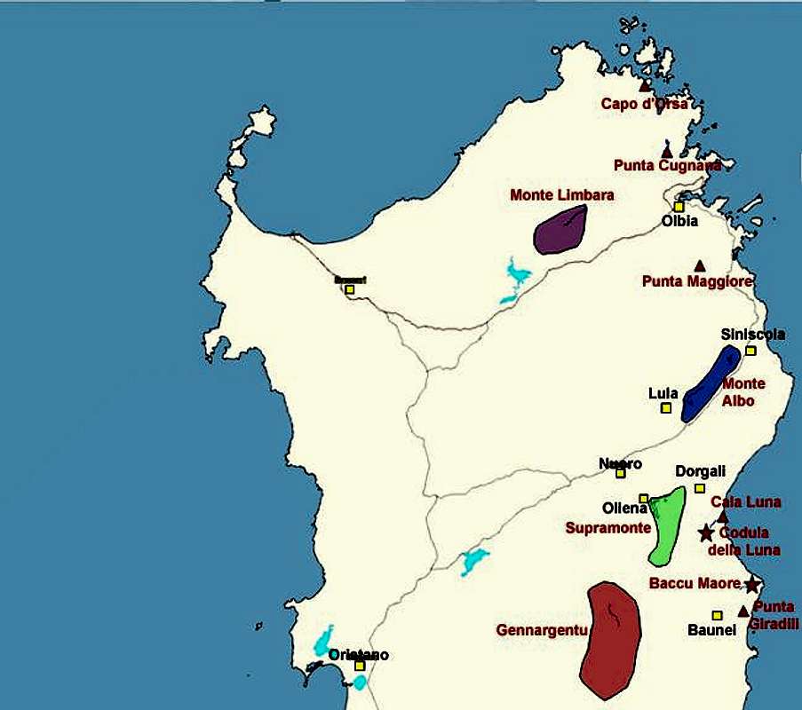
40.22540°N / 9.62620°E |
|
|
377 ft / 115 m |
|
|
Overview
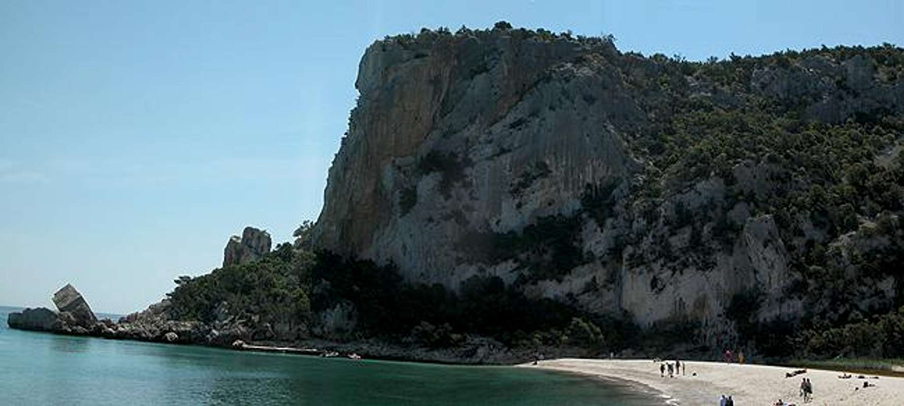
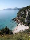
Cala Luna is arguably the most popular climbing region in Sardinia. It is a solitary beach located some 4km south of the town of Cala Gonone and shows some of the best climbing crags and caves on the whole island. To the north of the beach you will find beautiful overhanging caves while on the southern side there is a large 100m high crag which is very popular with climbing photographers. Add the emerald green sea and you have a place that leaves no wish unfulfilled.
The name Cala Luna stems from the half moon form of the bay. It gave its name to the accompanying gorge Codula della Luna as well as the climbing crag Pietra della Luna. The bay - as stated above - can only be reached on foot or by a small passenger ferry which does the trip back and forth to Cala Gonone every hour. Most people hike the trail - only the climbers take the ferry - who wants to carry all that climbing gear all the way?
Codula della Luna would in principle register as a route to Cala Luna but it is a sight in its own right. There is a great hiking trail through the gorge and - as said above - numerous opportunities to do some serious climbing. The higher up you get in the gorge, the more overgrown everything gets, so probably the best crags are still in the vicinity of the beach.
While preparing this page I stumbled across a statement on another website which I will repeat here - though at the moment I cannot say where it is from:
"Cala Luna - a stunning unspoilt beach. For those of you that have been to Thailand, and climbed on Anderman Beach, this is better. Araj, probably one of the best 7a+s in the world. Great caves, great routes, great beach, and thank god it's (only an) 1 1/2 hr walk in when the ferry's not working. Hopefully this place will remain as unspoilt as it is today."
Nothing more to be said ....
 |
 |
 |
 |
Climbing in the Cala Gonone Area
Cala Luna belongs to the climbing area of Cala Gonone. I'm no climber myself so it would be useless for me to post routes. Therefore I'll give a short overview and direct you to the respective mountain pages which explain better than I can. Most of the infos are taken from www.rockclimbing.com
Cala Luna
The beach has two climbing areas:
- Grottoni - the caves and overhangs north of the bay. Short but difficult routes ranging from 6a+ through 8a+
- Scoglio/Pietra di Luna - a 100m high rock directly above the sea with some ten routes ranging from 5 through 6b+. Easier than the Grottoni but exposed from the start.
See: - www.rockclimbing.com/cala_luna
- www.rockfax.com/cala_luna
Cala Fuili
This is the trailhead for the hike to Cala Luna. You can get down to the beach and start an amazing amount of routes (almost 40) from there. Three areas: - Settore Ferry - 12 climbs rated 4+ through 6a+
- Settore Spigolo - 8 climbs rates 5 through 7a+
- Settore Pederiva - 16 climbs between 6a+ and 8b
See: - www.rockclimbing.com/cala_fuili
- www.rockfax.com/cala_fuili
Cala Gonone
Directly close to the village there are three climbing areas with up to 70 routes! - Budinetto Main - 21 routes ranging from 5 through 6c+
- La Poltrona - 25 routes between 4+ and 7a
- Biddiriscottai - the most popular of them all - a cave with beautiful overhangs. 23 routes rated 5 through 7c
See: - www.rockfax.com/cala_gonone
- www.rockclimbing.com/biddiriscottai
- www.rockclimbing.com/la_poltrana
![]()
![]()
![]()
![]()
Codula della Luna
As already said in the overview section Cala Luna is the endpoint of a gorge which is cut deep into the Supramonte di Baunei region. The gorge is rather wide (up to 200m) but shows beautiful vertical limestone walls in its lower part. The gorge has its own SP page - here there are only pictures of the walls close to the bay.
![]()
![]()
![]()
![]()
The Trecking Trail "Sentiero Selvaggio Blu"
There is a multiday trecking trail along the eastern coast of Sardinia - Sentiero Selvaggio Blu. It is - as trecking trails go - an extreme trail, since it contains passages of grade IV as well as some rappeling. The trail starts at Pietra Longa and runs through all the climbing areas of the east coast - Punta Giradili, Cala Goloritzé, Cala Luna - before it finally ends at Cala Gonone. The average trecking time for the whole trail is eight days. The trail is marked (by blue arrows) but much of it is overgrown so you need a quite good sense (and equipment) for orientation.
The parts at the northern and southern ends are the easiest ones. Just simple hiking trails which in some places are overgrown by macchia. The route from Cala Fuili to Cala Luna is the northernmost part of the sentiero.
Getting There
Sardinia can be reached either by plane or by ferry. The main ports are Porto Torres and Olbia in the north and Arbatax and Cagliari in the south. Airports are at Alghero and Olbia in the north as well as (again) Arbatax and Cagliari in the south. For exploring the northeastern part of the island where most of the mountains are the best entry point is Olbia, which is where most flights go anyway.
Approaching Cala Gonone from Olbia airport
Get on motorway SS 131 south in the direction of Siniscola / Nuoro. At the exit Lula / Dorgali get off and turn on SP38 south (again direction Dorgali). Shortly before you reach Dorgali, SP38 ends and you switch to SS125 direction Dorgali.
Get through the town (signs Cala Gonone, Baunei) and soon afterwards the road to Cala Gonone turns off through a tunnel to the left. The road descends to Cala Gonone where you can get on the passenger ferry to Cala Luna. The hiking trail starts some 5km south of the town at Cala Fuili. Take the coastal road southwards to its end.![]()
- Dorgali (only Italian)
- Cala Gonone
Camping...
... is also easy to find in the vicinity of the beaches. Look for locations, using www.sardegna.com.
Free camping near the beach is possible. Ask the proprietor of the bar at the beach.
Weather Conditions
Go for the following link, which is in Italian but with ALL the information you might want to have on weather on the island:
www.sar.sardegna.it.
Head for the "meteo" button and then on the "Bollettino dettagliato" link in the left frame.
Maps 'n' Books
As for Maps I used only a road map scale 1:200000 since the guidebook I used has maps and is really quite good. Don't be fooled by the durations they state, you'll be much faster but the "getting there's" and "route description's" are very good.
The book is:
Sardinia (Sardegna / Sardinien)
M. Omidvar
Rother Verlag
ISBN: 3-7633-4800-X (English)
ISBN: 3-7633-4143-9 (Italian)
ISBN: 3-7633-4023-8 (German)
For climbing in Sardinia there is a book, called Pietra di Luna by Maurizio Oviglia, which is available in Italian, English and German. Click on the image to be directed to a web page with more (also ordering) information.