
|
|
Canyon |
|---|---|
|
|
36.15400°N / 109.552°W |
|
|
Hiking |
|
|
Spring, Summer, Fall, Winter |
|
|
Overview
Canyon de Chelly in eastern Arizona is one of the longest continually inhabited places in North America. It is estimated that people have been living here for over 1,500 years and to this day it still sustains a community of Navajo People who are intimately connected to their landscape. And what a landscape it is! There are over 2,700 archaeological sites in the beautiful canyon that was carved through sandstone by the Rio de Chelly. The canyon at its shallowest is 30 feet deep but at its deepest is about 1,000 feet deep.The canyon is on Navajo land and is managed jointly by the tribe and the National Park Service as Canyon de Chelly National Monument which was established in 1931 and encompasses 83,840 acres. As a result there are some restrictions that usually aren't in place in other National Park Service areas. For instance, you must be accompanied by a Park Ranger or Navajo Guide when you enter the canyon on all trails except the White House Ruin Trail. See "Red Tape" section for more info.
For good views of the canyons and ruins take the two rim drives.
- South Rim Drive, 36 miles round trip leads to five overlooks
- North Rim Drive, 32 miles round trip, leads to three overlooks.
Some of the highlights of these drives:
Views of First Ruin and Junction Ruin from Junction Overlook.
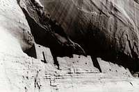 White House Ruin
White House Ruin, the best known Anasazi cliff dwelling in the canyon. It is named after a long wall in the upper ruin that is covered with white plaster. The ruin is reached over a 2½-mile roundtrip trail from White House Overlook. A guide is not required for this hike, but you must stay on the trail going to and from the ruin.
Spider Rock, an 800-foot sandstone spire rising from the canyon floor at the junction of Canyon de Chelly and Monument Canyon.
Getting There
The Canyon de Chelly visitor center is 3 miles from Route 191 in Chinle, AZ. Click here for an area map.Click here for a detailed park map.
Red Tape
To drive on the canyon bottom, a 4-wheel drive vehicle, a Park Service permit and an authorized Navajo guide are required. The fee is $15 an hour for 1 vehicle, $5 an hour for each additional vehicle with a 5-vehicle limit per guide.Hiking within the canyon requires a Park Service permit and an authorized Navajo guide, except along the 2.5-mile (4-km) White House Ruins Trail. One guide may take up to 15 people for $15 per hour.
When conditions are suitable, Thunderbird Lodge, near the monument headquarters, offers commercial trips up the floors of the canyons in vehicles especially equipped for canyon travel.
 Pictographs in Canyon de Chelly
Please do not enter a hogan or take photographs of Native Americans without their consent.
Climbing Spider Rock is not allowed in respect for the wishes of the Navajo people who consider this a sacred rock. Click here for more info.
It is unlawful to enter any ruin of an archeological site, or to deface, disturb or destroy any natural feature or artifact.
Please practice Leave No Trace ethics!
Because the monument is on the Navajo reservation, alcohol consumption or possession is prohibited.
Camping
Cottonwood Campground (elevation 5,540 feet) is 1/2 mile south of the Visitor Center. It is open year round on a first-come first-served basis. It includes 104 RV and tent sites. From April to October facilities include flush toilets, picnic tables and drinking water. There are no shower facilities. No fee required.Group tent camping is also available for 15-25 people in organized groups by reservation only. Make reservations by calling the Monument at (928) 674-5500. No reservations are accepted for RV groups.
Backcountry camping is allowed with an authorized guide. Call the Monument for more info (928) 674-5500.
Another option: Privately owned Spider Rock Campground and RV Park
External Links
 Descent into Canyon de Chelly
Canyon de Chelly National Monument Website
Weather Forecast from the NWS for Chinle, AZ
Canyon de Chelly Climate Summary
Footpath Journeys, Guided Navajo Tours
Antelope House Tours
Navajo Central.org
Etymology
The name De Chelly is a Spanish corruption of the Navajo word "Tsegi", which means roughly "rock canyon". The Spanish pronunciation "day shay-yee" has gradually changed through English usage, and the name is now pronounced "d'SHAY". The Spanish name of the chief tributary of Canyon de Chelly, Canyon del Muerto, means "Canyon of the Dead". It received its name in 1882, when a Smithsonian Institution expedition under James Stevenson found the remains of prehistoric Indian burials in this canyon.For more information, please contact
Canyon de Chelly National MonumentPO Box 588
Chinle, AZ 86503
(928) 674-5500