When I decided to join a group to descend a tributary in the Middle Fork of Lytle Creek in the Cucamonga Wilderness area of the eastern San Gabriel Mounains, pleasant memories were not the first thing that popped into my head. I had my first outing to the mountains somewhere in this area when I was 8 years old. My favorite uncle took me to a camping/picnic area so that I could use the BB gun he had bought me and to enjoy the outdoors. For whatever reason, I was barefoot and carelessly ran through a pile of white-hot barbecue coals some reckless picnickers had spread on the ground. The bottoms of my feet immediately turned into a horrendous, solitary blister from heel to toe. I had a miserable time recovering from the episode.
Into the Cucamonga Wilderness
Middle Fork of Lytle Creek
This Saturday I had my shoes on and we would not run into any picnickers. Our group of ten experienced canyoneers met at the Middle Fork trailhead and headed up the trail into the Cucamonga Wilderness area. In about an hour and a half, we reached our drop-in point at near 6,000’ elevation. The beautiful waterfalls that we would encounter were situated in the upper reaches of a large tributary off the main canyon.
The Raps: A Snow Bank, An Avalanche Gully, A Near Miss, and A Challenging Final Drop
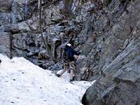
We did 4 rappels of 160’, 110’, 80’, and 50’. The first rap was 80’ and straightforward except that the landing was onto a slippery snow bank. We had to tread carefully to get off the snow bank without going for a long unintended glissade.
Belaying the rap into snowbank
Getting of the snowbank
Coiling the rope
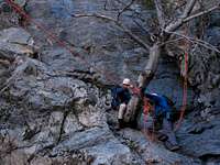
On the second rap, we set up a guideline. We adopted the KISS principle in setting up the bottom of the guide rope: it was wrapped 3 times around a tree (enough friction to be bombproof). However, the wraps didn’t provide enough tension to keep the guideline from sagging as it was weighted, so the bottom of the guideline was reconfigured with an “in-line 8” tension set-up. On this rap, a lively, cold waterfall was flowing just underneath the rappel rope and you had to tuck your knees to your chest as you started the rap until the guideline moved you away from the waterfall.
Rap line and upper guideline on 2d drop
The third drop was quite a distance from the first two and took us across a large gully that had been recently avalanched. It was quite sobering to see the rubble of large trees strewn hither and yon like toothpicks.
Evidence of recent avalanche in gully we crossed
At this third drop, a good 110 feet, the most feasible anchor was positioned well below where the rappel rapide draped over a rock edge. From the top, we couldn’t see the bottom of the drop so we would have to adjust the rope if necessary after we threw it. I started down and discovered that the rope (single strand rappel) was about 30’ short of the landing. With pre-arranged whistle signals (from the top you couldn’t see or hear a person at the bottom), I asked to be lowered to a ledge. At the ledge, I got off rappel and was able to down climb the rest of the way.
I yelled “clear” for the next person to come down and started to provide a fireman’s belay. Without time to react, I heard the distinct sound of rocks detonating down the route. The rocks whistled by me about two feet away. Without doubt or exaggeration, had I been 2 more feet to my left, I would have been history. Needless to say, I scooted away from the area and warned everybody above to be extra careful at the bottom.
While the rest of the party came down the third drop, three of us started working on the set up for the last rappel. This one required some creativity. We would need to set up two separate anchors for a two-stage rappel. To get to the tree that would serve as the first anchor required that we set up a 25- foot hand-line down to the tree because of the steepness of the face. After the first anchor was built the first man rapped 50 feet to another tree which would serve as the second anchor.
2d anchor on last drop
Because we wanted to avoid getting soaked in ice cold water on this winter day, we opted for another guideline set-up that would avoid rappelling under a waterfall and dropping into a thigh-deep pool below the waterfall. Our most experienced member accepted the honors of being first man down to build the guideline. He took off his boots and stripped to this shorts to rap into the pool and out to a large tree where the bottom of the guideline would be anchored. The guideline was anchored using an inline figure 8 with a mule hitch tie-off. The guideline was set high in the tree so that it would be elevated enough for everyone to clear the pool as they came down.
On guideline on last rap
The tricky part on this two-stage rappel was unrigging from the first rappel and then rrigging to rap from the second anchor and clipping into the guideline. The problem was that the terrain was near vertical and there was no place to stand to transition between the two rappels. Our last man down assisted everyone with the awkward stance at the second anchor. The guideline worked great except that forward progress stopped about 25 feet from the bottom anchor. I simply unrigged from the guideline and pulled hand over hand on the guideline rope to get myself to the end.
Owing to the involved set-up on this last rappel and the size of the group, it took over 2 hours to get everyone down. But all got down happy and we fairly bounced back to the trailhead after a beautiful wilderness experience. It made up nicely for my first painful experience in this area.
okay definitely, the best and the most vivid Trip Report I have seen on SP. Love all the photos, and all those great Youtube videos.
Great job, love it,
Marc
Are you aware of a name for these falls? It took me three trips of getting lost before I found them. We went camping about 4 miles after the falls this last New Years eve in a snow storm. Simply amazing trip. Nice report.
I did these falls in June 2020 and found the flow to be moderate high, closer to a 3CIII than the promised 3BIII. I did 5 rappells instead of the 4 mentioned in the article. Crazy seeing that much snow! I missed out having done the falls in the summer time. My trip report is here:
Parents refers to a larger category under which an object falls. For example, theAconcagua mountain page has the 'Aconcagua Group' and the 'Seven Summits' asparents and is a parent itself to many routes, photos, and Trip Reports.


Comments
Post a Comment