
|
|
Canyon |
|---|---|
|
|
34.25900°N / 117.499°W |
|
|
Hiking, Mountaineering, Bouldering, Scrambling, Canyoneering |
|
|
Spring, Summer, Fall, Winter |
|
|
Overview
Lytle Creek and its three main forks tumble down rugged wilderness canyons on the southern slope of the eastern San Gabriel Mountains. This is part of the San Bernardino National Forest but it's not too far from its border with the Angeles National Forest. What I love most about these mountains and these canyons is the raw awesome beauty of it all. The San Andreas Fault is only a valley away so this area is under the constant threat of earthquakes, not to mention flash flood, rock slides, and fire. But it is beautiful nonetheless. And there are lots of trails and remote trail-less areas to explore, peaks to bag, and sites to see.
Bighorn sheep, mule deer, mountain lions, bobcats, foxes, coyotes, and bears are just some of the animals that can be seen in the canyon. The lower elevations are covered by chaparral and the higher elevations by oak, sugar pine, ponderosa pine, and bigcone douglas fir. Sycamore trees, willow, and alder are common along the creek itself. Also watch out for poison oak and stinging nettle!
Getting There
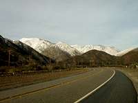
Lytle Creek Canyon
The easiest way to get to the main fork of Lytle Creek is via paved road. Take I-15 north of Rancho Cucamonga or south of Cajon Pass. Exit Sierra Avenue and head north. Sierra turns into Lytle Creek Road and you enter the canyon in just a mile or two. Four miles up the canyon you will come to the Lytle Creek Ranger Station on the right-hand side of the road. It is open 7-days-a-week from 8:00 am - 4:30 pm. Stop in to see the animal exhibits, get information and permits, buy maps and books, and to stroll around the native plant garden in the back. The flowers in it bloom in April and May and are lovely!
About 6 miles up the canyon is the small community of Lytle Creek. There is a post office, general store, restaurant, and an art gallery here. Parts of this community are quiet and quaint, others are run-down and populated with rowdy people. Apparently this is one of the hang-out spots for the Hell's Angels.
You can also enter the main canyon via unpaved roads - the Swarthout Canyon Road links to Old Highway 66 near Cleghorn Road and Lost Lake or to Lone Pine Canyon Road near Mormon Rocks. From here you can head up and over the Sheeps Canyon Road to Lytle Creek Road.
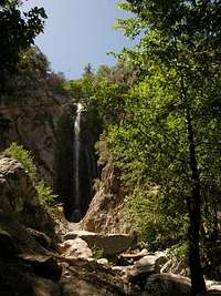
Bonita Falls
To access the South Fork park about one mile above the Ranger Station near the sign for Green Mountain Ranch. Here you will see the prominent South Fork Canyon intersecting the main canyon. Cross the main stream and head west. One attraction up this canyon is Bonita Falls which is the 2nd highest waterfall in Southern California. In total its 4 tiers drop about 475 feet. Although only 3/4 miles from the road, Bonita Falls isn't what I would call an easy hike... there isn't a maintained trail rather you make your way up a very rocky streambed dodging boulders and down trees and other obstacles. Here and there you'll find bits of a user trail but I found it's easiest, and coolest, to just put on shorts or capris and a good pair of sandals like Keen's and just hike up through the water of the creek. Even on a hot day you can stay relatively cool this way. The last scramble up to the lower tier of the falls is the toughest but is worth it. The waterfall is absolutely beautiful. You can stand beneath it and get the most refreshing of nature's showers. And then sit beside it a spell and watch the hummingbirds buzz around the flowers growing in nooks and crannies in the cliff. Go Jan-May to see the best water flow. But I would avoid crossing the stream and hiking in the canyon during flash-flood times.
To access the Middle Fork about 2 miles above the Ranger Station turn left on Middle Fork Road. This road is paved at first but quickly turns to a rough gravel road. High clearance vehicles are recommended and 4wd isn't a bad idea, either, especially during the rainy (winter) season. At the end of Middle Fork Drive is one of the main trailheads for the Cucamonga Wilderness. If you hike up the Middle Fork Trail you will come to several backcountry camps and eventually Icehouse Saddle and Cucamonga Peak if you choose.
To access the upper North Fork, just continue up Lytle Creek Road (3N06). Near the firing range this paved road turns into a gravel/rock road (high-clearance recommended, and if the road surface is wet/snowy/icy then you'll need 4wd). A few miles up this road Coldwater Canyon Road (3N06A) splits off from it going to the left, crossing the wash. Vehicles are not allowed to travel up and down the wash itself. You will need high-clearance and 4wd to drive up to Coldwater Canyon. A few more miles up 3N33 splits off to the right (road is currently closed due to the Sheep Fire, but when open climbs up to Gobbler's Knob). Another mile or so and Paiute Canyon Road (3N06B) splits off to the right, again high-clearance and 4wd is required. 3N06 continues up to a camping area called Stockton Flats and eventually ends at a gate. You can walk up the road behind the gate and reach Baldy Saddle at the Mt. Baldy Ski Resort.
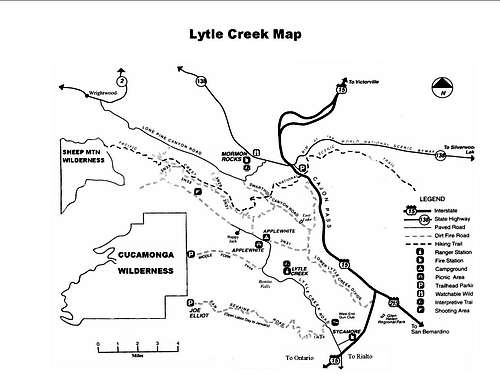 Lytle Creek area map
Red Tape
Adventure Passes are required to park along the Lower main canyon and Middle Fork of Lytle Creek. They are $5/day or $30/year. Interagency Passes are also accepted. Click here for more info!
If you are going to hike in the Cucamonga Wilderness you will need a wilderness permit. These are free but there is a quota on the campsites. Call or stop in the Lytle Creek Ranger Station for more information!

South Fork Lytle Creek Canyon
No campfires or charcoal bbq's are allowed in the wilderness or along the creek. They are only allowed certain times of the year at Applewhite Campground, Applewhite Picnic Area, and the yellow-post sites. You will need a campfire permit to have one at the yellow-post sites and these can be obtained at the Ranger Station. Click here for current fire restrictions and other current info.
Please practice Leave No Trace ethics. Since the creek area is a very popular area for families escaping the heat from the valleys below, I recommend bringing an extra trashbag or two to hand out to them or volunteer 10 minutes of your time picking up after less-thoughtful visitors. There is a local volunteer group, also, that you can join. Remember if you volunteer 100 hours you can receive a free annual Adventure Pass! 300 hours and you receive the Interagency Annual Pass.
I recommend exploring Lytle Creek most anyday except for a hot weekend day. Expect to find the canyon brimming with families swimming and picknicking and parking hard to find. Come during the winter or mid-week and you'll find almost nobody...
Camping
The nearest campground is Applewhite Campground. It is about 7 miles up the canyon from I-15. It is largely populated on any given weekend with families and tourists and across the street is the popular Applewhite Picnic Area. It's open year-round, the cost is $10/night, and it's first-come, first-served. There are picnic tables, fire rings, water spigots, and flush toilets here.
There are also several different "yellow-post" campsites further up in the main canyon. These are open in the late spring, summer, and most of the fall. They may be closed with winter snowfall. See below or ask for a map to these remote dispersed sites at the Ranger Station. There is no water or bathrooms available at these sites nor trash pick-up, so pack-in-in, pack-it-out!
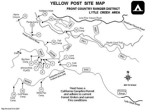 Yellow-post sites
External Links
San Bernardino National Forest
Weather for Lytle Creek, CA
Lytle Creek History

Middle Fork Lytle Creek Canyon
From a San Bernardino National Forest brochure:
"Welcome To Lytle Creek - You are entering a little known canyon in the San Bernardino National Forest that has a very colorful past.
Early Inhabitants - The first residents in Lytle Creek Canyon were the Serrano Indians who lived in the San Bernardino Valley and adjacent mountain areas. It is believed the Serranos moved from the San Bernardino Valley during the hot summer months to the cooler Lytle Creek area where they gathered acorns, fished and hunted.
Later, as California become a Mexican Territory, explorers and eventually early settlers came to the area. The Mexican Governement awarded large parcels of land to ranchers. Ranchers grazed their cattle along the hillsides of the present day Cucamonga Wilderness. Hunters and trappers also came with the promise of a new wild land, and wild and dangerous it was. One early trapper, Isaac Slover, was killed by a grizzly bear in October 1854 near the present day Lone Pine Canyon Rd.
The Mormons were the first who showed any real interest in establishing a permanent settlement in Lytle Creek. In 1851, Brigham Young sent three companies of Latter Day Saints to assist in the war with Mexico. By the time they got to the area, however, the war was nearing an end so they established settlements. In June of 1851 they posted camp at the mouth of Lytle Creek Canyon, in a grove of Sycamore trees, surviving by hunting the land and fishing the waters. Captain Andrew Lytle was one of the commanding officers from which “Lytle’s Creek” or Lytle Creek got its name. Though Captain Lytle did not stay long, others remained in the area establishing small farms.
By the 1800s, with the influx of foreigners, and establishment of missions, the traditional way of life for the Serrano came to an end.
Gold Fever - In the mid 1800s gold fever hit California and Lytle Creek was no exception. Hundreds of prospectors and hopefuls hurried into the canyon and staked claims. Most findings taken from the canyon were fairly small but some nuggets (chispas) were discovered. Texas Point Mine was the most intense hydraulic mining operation. At its peak it was yielding $2,000 per week. Hydraulic mines often contaminate water supplies and the Texas Point was no exception. In the late 1800s the owners lost a court case in the Supreme Court. As a result all hydraulic mining was outlawed on Federal Lands. As you come into the canyon, to the left, you will see the scars from this mine on the hill beyond the gate for San Sevaine Rd.
Horse Thieves - There is also evidence that horse thieves used upper Lytle Creek as a refuge for stolen animals in the 1850s and 1860s. The Mason Henry gang was said to have brought their stolen horses into the canyon, with hideouts both in the Mt. Baldy and San Sevaine Flats area.
A Grape Idea - In the late 1870s, two French brothers, the San Sevaines started a vineyard in Rancho Cucamonga. Short on water, they attempted to build a flume to carry water from the mountains above. Though the flume did not work, the name San Sevaine stayed, as the name of the forest road that connects Lytle Creek Canyon to Ranch Cucamonga.
A Traveler’s Paradise - On the right side of the road is Mountain Lakes, a present day resort. This membership only RV Park has a set of trout ponds, swimming pools and arcades. Mountain Lakes Resort has a long history in Lytle Creek with vacationers traveling to the ranch for over 150 years. Silas Glenn was the original owner. In 1865, his family planted orchards of apples, raised livestock and entertained traveling families with dances, camping and fishing. Many railroad travelers would make the stop at the Keenwood Station and take a horse and buggy over to the early day resort as a reprieve from their travels.
Silas Glenn turned over his ranch in the Cajon Pass area to his son-in-law, James Applewhite instead of his own sons, and the Glenn brothers were worried that he would also deed the resort to Applewhite. One night the two sons called Applewhite out over the matter, but Applewhite had the upper hand. Both sons were shot and killed. Forty years later, the bullet holes could still be seen in the front door.
Glenn Ranch was not the only resort in Lytle Creek. In 1907 Green Mountain Ranch located on South Fork opened. Visitors enjoyed dancing, dining, and shows there. It is still open today for special events.
The Town of Lytle Creek - Today, within the city of Lytle Creek, lie three small towns which make up a community of about 2,000 people. The small towns are Scotland, Tally’s and Happy Jack.
William Campbell Scott, a developer, bought land where the Middle Fork meets the North Fork of Lytle Creek. In the 1930s, he opened a market and subdivided the land to create the town called Scotland. By the 1930’s a café, dance hall and service station brought diversion to locals and visitors alike. In 1921, Seymour Tally subdivided land and Tally’s was developed.
In 1905, Joseph “Happy Jack” Pollard came to Lytle Creek as a miner, and he was known for his nightly entertainment, geniality and humor. He subdivided his ranch for sale in the 1920s. The promoters claimed that each plot had a stream with running water (even though the stream did not currently run through every property). They took a tractor and dug a ditch leading from the stream, so that indeed every property had running water!
US Forest Service - The San Bernardino Forest Reserve was created in February 1893, in order to protect the watershed and halt the indiscriminate hunting, grazing and logging. By July, 13 1900 the forest reserve hired their first Ranger for Lytle Creek. Ranger Casey lived in the lower canyon and served as ranger until 1903. In 1905, the forest reserve system changed to the US Forest Service.
Recreation and camping in the summer time was popular with vacationers. Campgrounds were set up at Bonita Falls area and Stockton Flats (named after the original owner, a gold miner).
Today, the Forest Service operates a ranger station, in Lytle Creek Canyon. As the district office for the Front Country Ranger District, the Lytle Creek Station manages nearly 200,000 acres of land.
We hope you enjoy your walk through history today."