

-
 5851 Hits
-
 80.49% Score
-
 12 Votes
|
|
Route |
|---|---|
|
|
46.10896°N / 10.59486°E |
|
|
Mountaineering |
|
|
Summer |
|
|
One to two days |
|
|
F+/PD-, I+ (UIAA) |
|
|
Overview
What's New on this Page?
* October 18, 2018 - Page adopted
* October 18, 2018 - Overhaul of the page
This page will be kept in honour of Franz Rota Nodari, the member known as Franz77, the former owner of this page, fell on Mount Concarena on March 2018 during a climb.
Carè Alto North West ridge (Normal route)
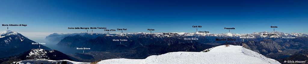
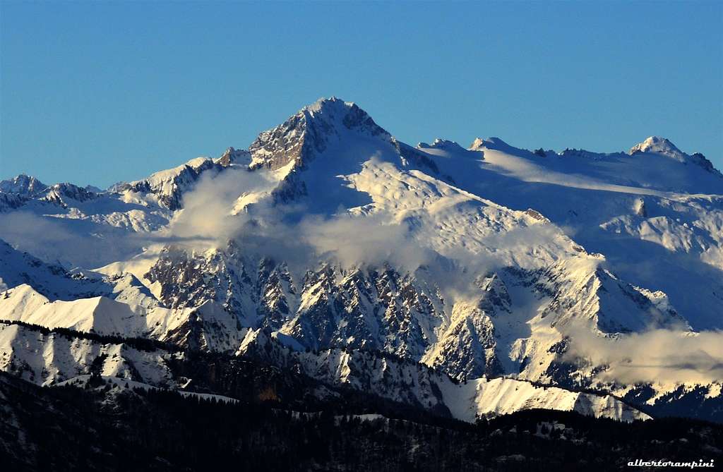
Carè Alto is one of the most important summits of the Adamello group, situated on the Southern edge of the Vedretta di Lares, between Val Rendena and Val di Fumo (Trentino region). It's a secluded and imposing peak, the highest one on Adamello South-Eastern Sector, so that it's easy to recognize and identified its shape. Carè Alto is a highly coveted peak by mountaineers, in reason of its remarkable importance, the great historical value and the spectacular views overlooking the Val di Fumo (South) and Lares glacier (North).
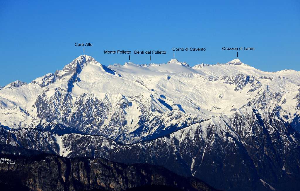
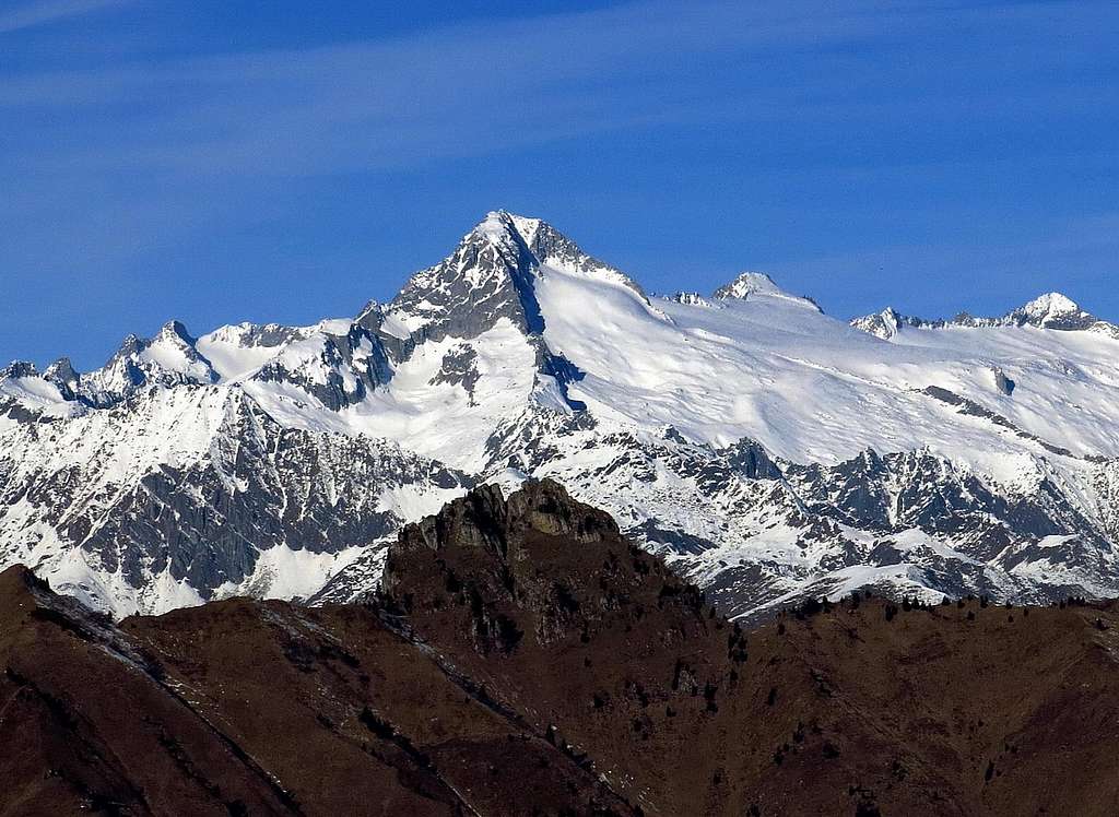
The rock is a particular kind of granite called "tonalite" and the mountain terrain is highly complex. Carè Alto shows five major ridges, heading NE, E, SE, SW and NW. Amongst these five ridges the only one originating from the summit is the North-West ridge, while the remaining four ones branch from the Northern fore-summit (N and E ridges) and the point 3361 or Southern fore-summit (SE and SW ridges). It's just along the North-West ridge that runs the Normal route, the itinerary described in this page.


Getting there
Road access to Val Rendena
Coming from Autobrennero exit Trento and take the road to Riva del Garda, reaching the village Le Sarche. Here continue straight toward Tione di Trento.
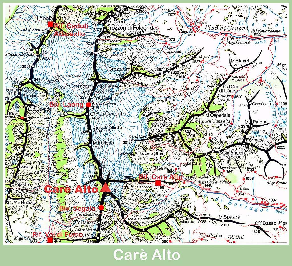
Road approach to Rifugio Carè Alto - In Tione turn to right and take the SS 239 Val Rendena route towards Pinzolo and Madonna di Campiglio, reaching Villa Rendena, Vigo Rendena, Pelugo and Borzago. In Borzago leave the main road 239 and take on the left the road entering Val di Borzago (signposts Rifugio Carè Alto), reaching the small hamlet of Case di Fe 1087 m, then Pian della Sega (7 km. from Borzago), where you must park the car (wide parking lot). From Val Borzago parking (reached from Valli giudicarie) it's necessary to reach Rifugio Carè Alto in 2/3 hours. Then, go up along the Valley of Lares and Niscli to reach the glacier near the Sella Niscli. There is some indication on rocks along the trail. You need other 3 hours to reach the glacier.
Route Description
Carè Alto North West ridge (Normal route)
Difficulty: Alpine PD
Difference in level: 1000 m from Rif. Carè Alto
Exposure: North-West
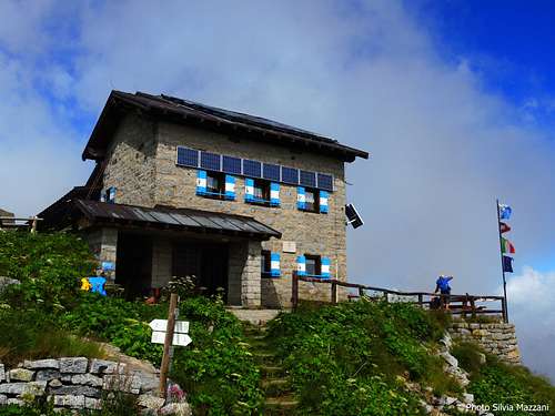
Hut: Rifugio Carè Alto 2459 m
Starting point: Valle di Borzago (Val Rendena)
The ascent from this side (route of the first summiters) doesn't oppose particularly difficult, but it requires glacier good practice and knowledge of rope work (possible descent rappelling).
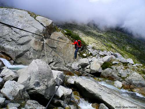
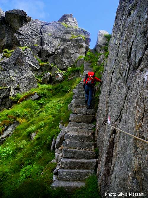
From Rifugio Carè Alto - Dante Ongari take the path n. 215 starting just behind the building, descending the rock staircase of “Bus del Gat”, then starting to cross the basin below the small glacier named Vedretta di Niscli. Soon cross a stream (Rio Bedù) along a cable bridge and continue to rise up the valley along the moraine reaching Sasso Bagnato, where there is a junction.
The main trail goes right to Passo Altar, we keep the left and continue up a moraine ridge reaching Pozzoni rocky band overlooking the small lakes and the saddle named Sella di Niscli 2912 m. (signposts) to the right of Sass de la Stria.
|
|
|
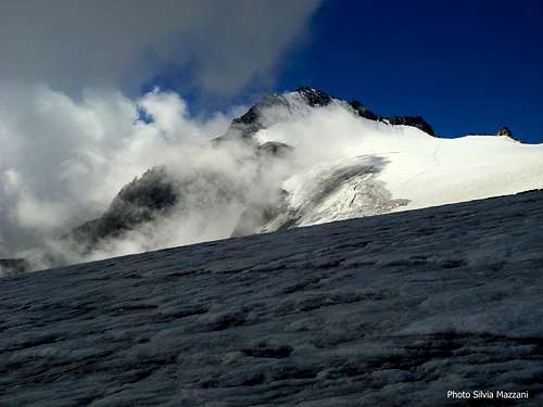
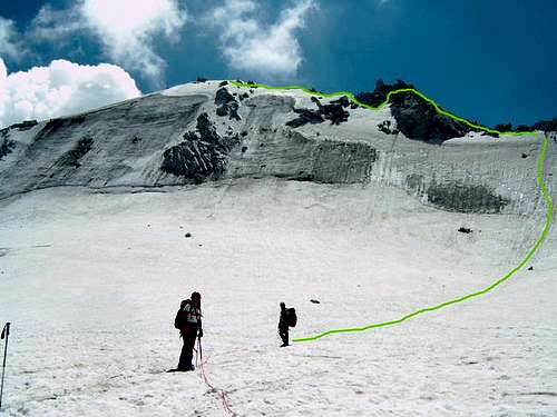
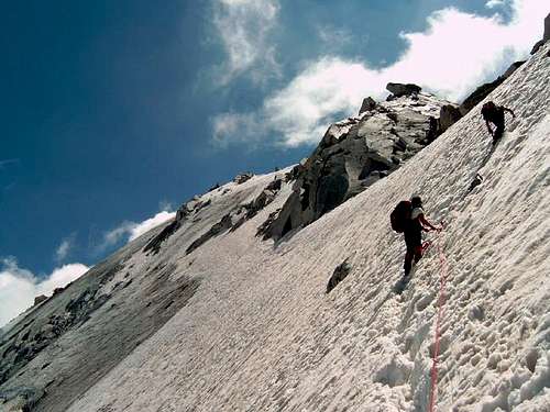
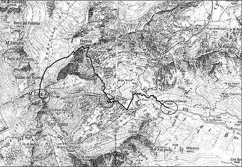
From the saddle cross uphill the glacier (Vedretta di Lares), at first in the West direction, then in the South direction, heading towards the North side of Carè Alto. Once getting the base of the mountain there are two possibilities:
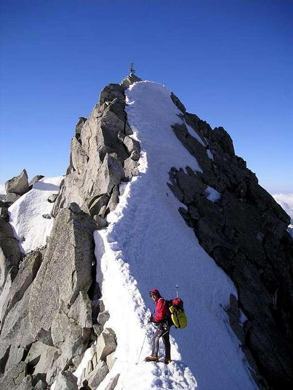
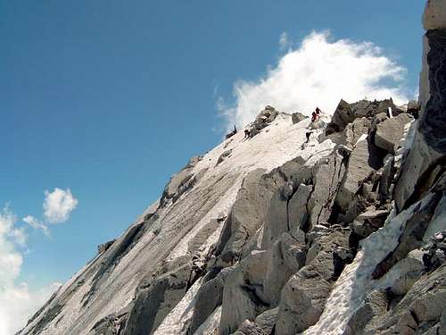
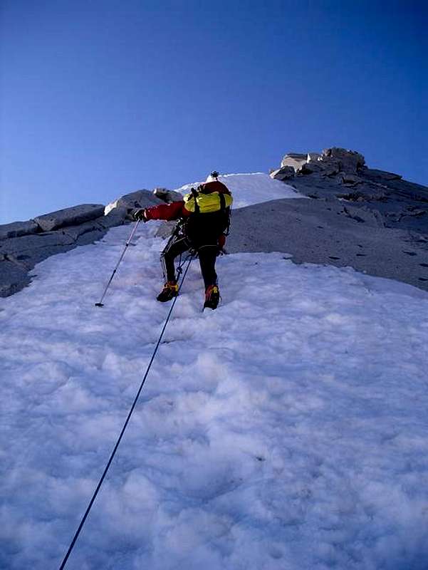
A - climb directly a brief steep icy or snowy slope located immediately near the North West ridge. It's necessary to start the climb as close to the ridge as possible, in fact moving away to the left the slope becomes very steep (50°). After climbing the slope reach the NW ridge in its central section, if the ice conditions are good. Climb on rocks or snow till the fore-summit. From this peak and the top there are 20 meters. You turn right and start climb the rock wall in the direction of the iron cross to the top.
B - in full summer the ice condition is often bad, so it's better to climb the ridge on the right, alternating snowy sections and rock steps, cross the North fore-summit and after a ridge and a notch reach the summit cross. Getting (marked) to the foot of the NW ridge (marks) the itinerary rises slightly diagonally along the ramps up to an anchor just below the ridge (an anchor is also present in the lower part of the initial ramp, visible depending on snow). Continuing as much as possible along the edge of the ridge (marked) to the summit.
Descent: it follows the same route. In the lower part it's possibile to do one or two abseils from the two fixed anchors to get to the Vedretta di Lares.
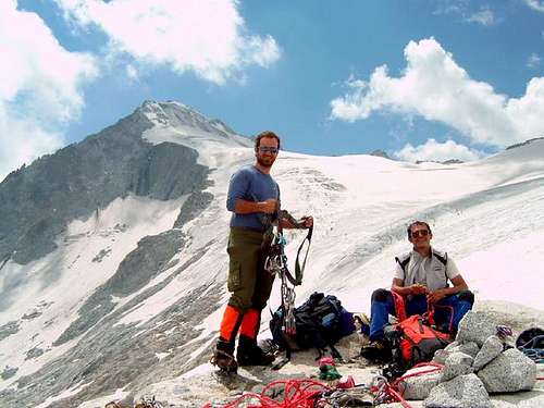
Essential Gear
Normal rope (50 m) for the glacier. Crampons, Ice axe, some ice pegs.
Red Tape

No fees no permits needed and no particular restriction in climbing and hiking. Carè Alto is situated within Adamello-Brenta Natural Park, the largest protected area in Trentino, established in 1967. It's located in Western Trentino and with its 620.51 square kilometers includes the mountain groups of Adamello, Presanella and Brenta Dolomites, separated by Val Rendena. Camping is not allowed and fires are strictly forbidden. The parking lot is free. In winter time the roads entering Val di Borzago may be closed due to snow cover.
Hut
- Rifugio Carè Alto-Dante Ongari 2459 m
Situation: East ridge of Carè Alto, on the side of Val Conca (Val di Borzago)
Open: from June 20th to September 20th
Size: 82 persons Winter-shelter: 8 persons
Owner: SAT Trento
Guardian: Marco Bosetti and family
Refuge's phone: +39 348 4359097 - +39 340 2943731
Walking approach - From the parking lot Pian della Sega in Val di Borzago (m 1250) take the old mule track through the woods and follow it until the alp Coel di Pelugo 1440 m. (30 minutes) from where it starts the cable car to the refuge. Take the path SAT 213 rising along steep turns, reach a tibetan bridge on a stream (rio Bedù di Pelugo), cross it and rise to the plateau above, traverse left and walk up the large rocky step, getting to the refuge (3,30 hours from Pian della Sega, difference in level 1200 m).
When to climb
The best period goes from June to September
Meteo
Meteo Trentino
Meteo ARPA Lombardia
Guidebooks and maps

-Guidebooks
"Adamello Vol. I - Pericle Sacchi Collana Guide dei Monti d'Italia CAI-TCI
-Maps
"Adamello - Presanella" - Tabacco scala 1:25000
"Adamello, Val di Fumo, Val di Genova" - Kompass n. 638
"Adamello - Presanella" - 4LAND Alpine Cartography n. 138 1:25.000
In Memory of Franz Rota Nodari

This page will be kept in honour of Franz Rota Nodari, the member known as Franz77, the former owner of this page, fell on Mount Concarena on March 2018 during a climb.
Francesco Rota Nodari, Franz for everyone, member of the Club Alpino Italiano Sez. Bergamo since 1987 and of the Club4000, died on March 23rd 2018 during a climb on Concarena 2549 m, the highest mountain of the Prealpi Bergamasche. He fell down during the descent from the mountain after having climbed a new route, due to the breakdown of a peg. Expert mountaineer, he had climbed all the 82 4000 of the Alps. He worked at the Polytechnic as an expert researcher in glaciology. He had joined SP in the year 2005 and registered as Franz77.
Rest in peace, brother!