
|
|
Route |
|---|---|
|
|
56.79787°N / 4.98951°W |
|
|
Hiking, Mountaineering, Scrambling |
|
|
Spring, Summer, Fall, Winter |
|
|
Most of a day |
|
|
Grade 1 Scrambling or Scottish Grade I winter climbing |
|
|
Overview
All good mountains should have a good ridge. Ben Nevis is no exception to this rule and is home to a number of fine ridge routes, one of the most famous being the Carn Mor Dearg Arête. It is so well know by British mountaineers that it is often abbreviated to just the 'CMD Arête' or sometimes simply 'The Ridge'. The route that traverses its knife edge crest between The Ben and its smaller neighbour Carn Mor Dearg is one of Britain's classic mountain routes, and thanks to its technical simplicity is enjoyed by thousands each year. Don't be put off by the potential busyness of the ridge, it's an enormously fun route, in summer forming an easy but exposed Grade 1 scramble and in winter transforming into a straightforward Scottish Grade I winter climb. The advantage of winter is that the crowds are gone and it becomes possible to enjoy the Arête without the chance of being caught in a queue . Winter is also the time of year that Ben Nevis is at its best, and completing the route can have an almost alpine feel. Despite the route being technically quite easy it should not be underestimated, the weather on The Ben can change rapidly, and once your on the ridge your committed. Numerous accidents have occurred, particularly when people have tried to escape into Coire Leis, and it is not uncommon for fatalities to occur. |
Getting There
 The Carn Mor Dearg Arête from Carn Mor Dearg (Photo by markradford) The Carn Mor Dearg Arête from Carn Mor Dearg (Photo by markradford)Although there are many possible approaches for the Carn Mor Dear Arête this page will describe only the most used, in this case the one that follows the Pony Track/Tourist Route around the base of Carn Dearg and along Allt a' Mhuilinn. Ben Nevis is located close to Fort William in the NW of Scotland and is served by both bus and train services. Some information about reaching Fort William by public transport, as well as the public transport is available here. Trains can be booked here. If you plan to take the over-night train between Fort William and London (or on route) then make sure you have a berth reserved. As a last resort there is a seated carriage but if this is full then you won't be allowed to ride the train. Citylink operate a bus service between Glasgow and Fort William. Some of these buses also continue to the Isle of Skye. Fort William can also be reached from Oban, Kyle of Lochalsh and Inverness. One bus a day runs to Mallaig and in summer a couple also go to Kingussie and Aviemore. Fort William is easy to reach by car. I'm not going to list every road route here so consult Google Maps or an equivalent. There is a no good or bad approach but on occasions roads close due to heavy snow fall. The approach route has two possible starts, they are located along the same road and are pretty easy to find. At the roundabout (NN 112 742) between Fort William and Claggan take the unclassified road signposting Glen Nevis east and then south-east along the glen following the southern side of the river. The first starting place is located at the large carpark (NN 122 731) just across the river from the Achintee Pub and Distillery (NN 124 730). The second starting point is some 1.5km further on down the road at the Glen Nevis Youth Hostel (NN 127 717). There is less parking here so unless you're starting particularly early or are staying at the hostel, then this probably isn't a realistic starting point in high season. |
Route Description
To get the best out of it this route has quite a long appraoch and the whole day should be allowd for its completion. In short it's around 16km long and could has over 1,700m of climb and could take as much as 10 hours to finish. The Approach If your starting at the Achintee carpark (NN 122 731) start by crossing the wooden suspension bridge across the River Nevis and follow the broad track past the Achintree Farm. Continue in a south easterly direction along a well defined path up a gradual climb follows the slope of the hill. After 1km or so you will meet the junction (NN 133 720) where this path joins the one starting at the Glen Nevis Youth Hostel (NN 127 717). If you have started at the hostel then your approach so far will have been short but steep. From the hostel cross the footbridge across the river and head in a slightly rough, but straightish path directly up the side of the hill past two very small plantations of forestry, until the path meets the junction. 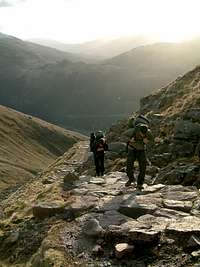 Pony Track near Red Burn (Photo by roadmountain) Pony Track near Red Burn (Photo by roadmountain)From the junction the paths converge and contour around the hillside, crossing two metal footbridges, before following Allt na h- Urchaire/ Red Burn towards Lochan meall an t-suidhe (NN 143 727). As you near the head of the valley you will be taken on a short diversion in order to allow soil regeneration on part of the slope. Continue to follow the path in a north-easterly direction for around 400m until you reach a small cairn/wall (NN 147 724), which marks a juncture in the path. Take the left hand turn and follow the path that contours along the western slope of Carn Dearg. The path is well maintained and should be quite obvious. After approximately 500m you will reach another junction. Take the right hand path which, is less well maintained and crosses some pretty boggy ground. This path will take you around the side of Carn Dearg and into the valley of Allt a' Mhuilinn. Follow the path up the valley to the CIC hut (NN 167 722), to reach it you will need to ford a number of streams which can be quite a challenge following periods of heavy precipitation. From the CIC hut, cross Allt a' Mhuilinn and contour along the western slope of Carn Mor Dearg, gaining a little height as you go to bring you onot the summit of Carn Beag Dearg (NN 171 735). From here follow the crest of the mountain in a south-easterly direction, first to Carn Dearg Meadhonach (NN 176 726) and then on to Carn Mor Dearg (NN 177 721) itself. From here the way ahead should be obvious with the mountains summit tapering off into the narrow arc of the Carn Mor Dearg Arête. The Route  Grim conditions on the Arete(Photo by Nanuls) Grim conditions on the Arete(Photo by Nanuls)Despite this pages long approach the actual route across the ridge itself is relatively short and requires very little information in the form of a description. Basically as you traverse the ridge it becomes narrower and more exposed as you near its centre. Here some difficulty may be encountered navigating the various small pinnacles and boulders by the inexperienced; however in general all problems can be avoided. As you near The Ben, the ridge steepens and broadens as it rises up the mountains eastern flank, before becoming a steep walk up to the summit. Escape 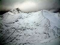 CMD Arete (Photo by Antony Walker) CMD Arete (Photo by Antony Walker)It is possible to escape from the ridge at the Carn Mor Dearg abseil post sign (NN 171 710) should you need to do so in an emergency. Only two of the higher posts remain and with care a person experienced in negotiating steep Grade 1 terrain in descent should be able to move down easily into Coire Leis. Often it's easier to traverse left (west) towards the Little Brenva Face, before descending. However, snow build-up will dictate the easiest and most obvious line down. The angle is steep at first, but eases after 150m. Be wary this is an accident black spot and although infrequent, fatalities do and can occur. The Descent The best and quickest descent is via the Pony Track/Tourist Route which will take you back to your starting point. A description of the route can be found on the Pony Track’s route page. |
Essential Gear
As with any mountain walk in Scotland, be sure to wear a good pair of boots, carry full waterproofs, hat, gloves and a fleece mid-layer or equivalent. In winter the route becomes a Scottish Grade I winter climb and an ice axe is advisable and crampons will be needed. You may also want to consider a rope and a skeleton winter rack just in case a quick escape from the route is required. Owing to The Ben’s northerly latitude and unpredictable weather, extra precautions should be taken in winter. A survival bag/bivy sack, head torch, emergency rations and even a snow shovel could save your life (or at least some fingers and toes) should you be injured or benighted. |
Maps
Guidebooks
External Links
 CMD Arete (Photo by munroitis) CMD Arete (Photo by munroitis)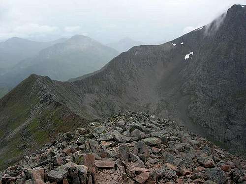 CMD Arete (Photo by Joerg Marretsch) CMD Arete (Photo by Joerg Marretsch)Scottish Mountaineering Club - Scotland's national mountaineering club The Mountaineering Council of Scotland - Scotland's official mountaineering body British Mountaineering Council - Britain's official mountaineering body Climbers Club - British national climbing club Nevis Range - ski centre information for the Ben Nevis area Visit Scotland - website for the Scottish Tourist Board Visit Fort William - tourist information for Ben Nevis and the surrounding area Munro Magic - information of the Munros The Highland Council - local authority home page Scottish Natural Heritage - Scotland's statutory body for the protection of landscapes Joint Nature Conservation Committee - Britain's statutory body for the protection of wildlife Nevis Sport - a major outdoor shop and mountain centre in Fort William Mountain Conditions West Coast Mountain Guides - Avalanche information, climbing conditions and weather forecasts. Abacus Mountaineering - Climbing conditions The Scottish Avalanche Information Service (SAIS) - Avalanche information Weather Mountain Weather Information Servise (MWIS) - mountain weather forecast Metcheck - 7 day weather forecast Met Office - Weather from the Met Office Weather Channel UK - Weather Channel weather Travel Lochaber Transport Forum - local public transport information National Rail - UK Train Timetable Showbus - bus timetables for the UK Citylink - Scottish bus timetables Inverness Airport - home page of Inverness airport BAA Glasgow Airport - homepage of Glasgow airport Glasgow Prestwick Airport - home page of Glasgow Prestwick Airport BAA Edinburgh Airport - home page of Edinburgh Airport Caledonian MacBrayne Ferries - ferry information and timetables for the wet of Scotland ecossenet: Taxis - list of taxi companies operating in the Fort William area Accomodation Visit Scotland: Fort William - an extensive list of accomodation in and around Fort William The Mountain Bothies Association - information on bothies (mountain huts) in Scotland Scottish Youth Hostel Association - home page of the SYHA Glen Nevis Youth Hostel - page of the Glen Nevis YHA Scottish Independant Hostels - a directory of independant hostels in Scotland UK Campsite.co.uk - directory of campsites in the Fort William area Maps and Guidebooks Ordnance Survey - Britain's national mapping agency Harvey Map Services - an excellent selection of maps designed specifically for outdoor enthusiasts Cicerone Guidebooks - guidebooks for people of all abilities Climbers Club Guidebooks - guidebooks for climbers Scottish Mountaineering Club - guidebooks and publications for and about Scottish mountains |
Nanuls - Sep 11, 2015 3:14 pm - Hasn't voted
Re: Update West Coast Mountin Guides web addressHi Ken All pages have been updated as requested. Many thanks Dan