Cascade Mountain (Elk Range)

Cascade Mountain (Elk Range)

Page Type Page Type: Mountain/Rock
Location Lat/Lon: 38.96160°N / 107.0984°W
Additional Information County: Gunnison
Activities Activities: Hiking, Mountaineering, Skiing
Seasons Season: Spring, Summer, Fall, Winter
Additional Information Elevation: 11715 ft / 3571 m
Sign the Climber's Log

Cascade Mountain Overview

Cascade Mountain and Mineral Point from PittsburgCascade Mountain (left) and Mineral Point A (right)
Cascade Mountain is a unranked peak in the Elk Range of Colorado. This mountain contains a summit with a flat top that only rises 175 feet above it's saddle with Augusta Mountain. It is located in the heart of the Ruby Range (which is a long extension to the Elk Range) around the area of Crested Butte. Even though it is unranked, it is very popular to climb because of it's popular neighboring mountains, Purple Mountain, Augusta Mountain, and Richmond Mountain. It is often approached from Angel Pass, but is sometimes approached from its direct NW face. The peak is more like a side trip from whatever your doing, but its views are astonishing and it is unlike any other mountain in the area. Its northwest face is a big rock wall with a large waterfall running down it; the waterfall has to be at least 75 feet tall. Early to mid-summer I'd say is the best time to see this mountain along with its waterfall and vibrant colors. If your visiting Poverty Gulch one day, Cascade Mountain is the rock wall to the left and I'd recommend you ascend it from anyway.

In-depth Details

From Poverty GultchFrom Poverty Gulch
Here are more details:

Elevation: 11,715 ft.
CO Peak Rank: unranked

Range: Elk (Ruby Range)
Counties: Gunnison

Quadrangle: Oh-Be-Joyful
Coordinates: 38.9616°N, -107.0984°W

Prominence: 175'
Saddle: 11,540 ft.

Proximate Parent: Augusta Mountain
Line Parent: Augusta Mountain
Isolation: 0.84 miles

YDS Class Rating: 2

Climbers Log

Getting There

Waterfall on Cascade Mountain
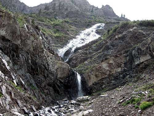
Close up view of the massive waterfall that spits down Cascade Mountain
From Buena Vista, make a left onto US 285. From there make a right onto US 50 up and over Monarch Pass and continue onto Gunnison. From Gunnison go North onto US 135 to Crested Butte. From here, make a left onto Slate River Road (County road 739A). Continue down this road until you see a sign for Daisy Pass Rd. From here a 4X4 vehicle is required. Continue down this road until you get to a side road that leads to a river crossing and seems to be entering Buckskin Basin. I don't recommend you go up this road unless you have a jeep with a short wheel-base. There has been a slide blocking the road from accessibility for several years, but as of August 2009 it is possible for a short wheel-base to get past it. But at this crossing is where you start.

From Aspen, head East onto US 82 over Independence Pass to Twin Lakes. From here, make right towards Buena Vista. From there make a right onto US 50 up and over Monarch Pass and continue onto Gunnison. From Gunnison go North onto US 135 to Crested Butte. From here, make a left onto Slate River Road (County road 739A) and follow the above.

Red Tape

Cloud coverCloud cover


No permit required unless you backpack off into the wilderness from this point. Please respect this area by packing it in and packing it out. In my 6 years of basically living up here during the summer, I've noticed that the increased amount of traffic has been carving an effect on the land scape so please stay on the trail.

Camping

There are many free campsites in Oh-Be-Joyful along with many others up and down the Slate River Road. You can tent camp in 4 or 5 different areas in Poverty Gulch. If on a rare occasion, all the spots up there are filled, don't create your own, camp on Slate River Road or Oh-Be-Joyful. I would not recommend bringing a camper up into Poverty Gulch.

External Links

http://listsofjohn.com/PeakStats/Climbers.php?Id=1956