

-
 86649 Hits
-
 98.63% Score
-
 86 Votes
|
|
Area/Range |
|---|---|
|
|
39.00970°N / 106.8608°W |
|
|
Hiking, Mountaineering, Skiing |
|
|
Spring, Summer, Fall, Winter |
|
|
The Elk Mountains
It makes sense dividing the Elk Range into three regions, the famous Maroon Bells Snowmass Wilderness(Maroon Bells, Capitol Peak/Snowmass Mountain, and the Conundrum/Taylor River area), the Raggeds Wilderness (Chair Mountain, Ragged Mountain and the Treasure Mountain massif) and the West Elks Wilderness(the Beckwith’s, the Owens Mountain massif, West Elk massif and the Anthracite Range.) Combined, all three regions provide the perfect introduction into Colorado's spectacular backcountry.
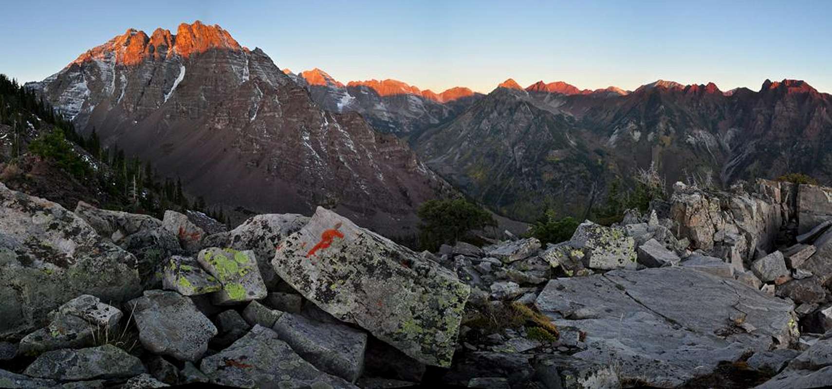
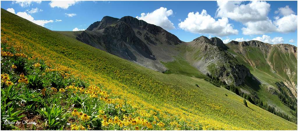
The high mountains of Colorado’s Elk Range are among the finest peaks in the Rockies. With Wilderness designation, these protected mountains are rugged, steep and aesthetically pleasing. Crystal clear streams, pristine alpine lakes and lush green vegetation are common sights.
The scenic beauty of the Elk Range is mostly due to its unique geology. There are two very distinct geological types of rock that are clearly evident in the Elk Mountains, the tertiary intrusives, and the stratified sedimentary. The whitish, gray rock of the tertiary intrusives is responsible for the sweeping, skinny ridges that connect point-to-point, evident in Snowmass Mountain, The Beckwith’s, Capitol Peak and the Chair Mountain massif. Second, the stratified purplish-red, sedimentary rock of the Permian age, evidenced in mountains like Cathedral Peak, Teocalli Mountain, Pyramid Peak, Maroon Bells and "Willow Peak."
Over the years, the Elk Range has have remained in respectably good shape, however some of the northern trails are beginning to show some over-use. Thanks to the Maroon Bells Snowmass Wilderness, we can visit large sections of mountainous terrain knowing not much has changed since early exploration.
Mountaineering in the Elks
The Elk Range has six fourteener’s and four centennial thirteeners. Indeed these mountains are some of Colorado’s most beautiful. However, beauty doesn’t necessarily translate into good climbing. The Elk Range has a reputation for loose and crumbling rock. Like most mountain ranges, some peaks are more dangerous than others; good routefinding skills are of paramount importance. Furthermore, most of the centennial peaks require top physical conditioning and good climbing skills. Only one of six fourteener’s has a walk-up route to the summit. In the Elks, the use of a rope can be more of a hindrance than a tool for safety. The potential for rock-fall is always nearby.The combination of abundant snowfall and generally steep and narrow valleys, makes access to these mountains a serious obstacle during winter months. Many of the valley slopes are ribbed with dangerous avalanche paths, which limits winter mountaineering to only the most daring and adventurous souls.
If you choose to spend time hiking and climbing the Elks, expect a different experience every time out. The experiences here vary: mostly epic, but occasionally bad. So play it safe and everything will work out fine.

TOPO Monster Maps
First, The following Overview map is interactive. Second, you will need highspeed internet to utilize this feature; it may take a few seconds to download. The numbered quads correspond to the viewable areas on the Overview map. Once opened, the thumbnails are set up to expand to show level 5 TOPO detail. Expand the image by clicking on the "Expand to regular size" (original size)icon on the bottom right of the image.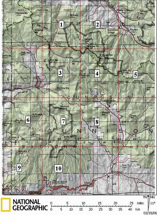
Unnamed, Ranked Thirteeners of the Elks
An officiall USGS Topo of every unnamed, ranked thirteener in the Elk Mountain Range.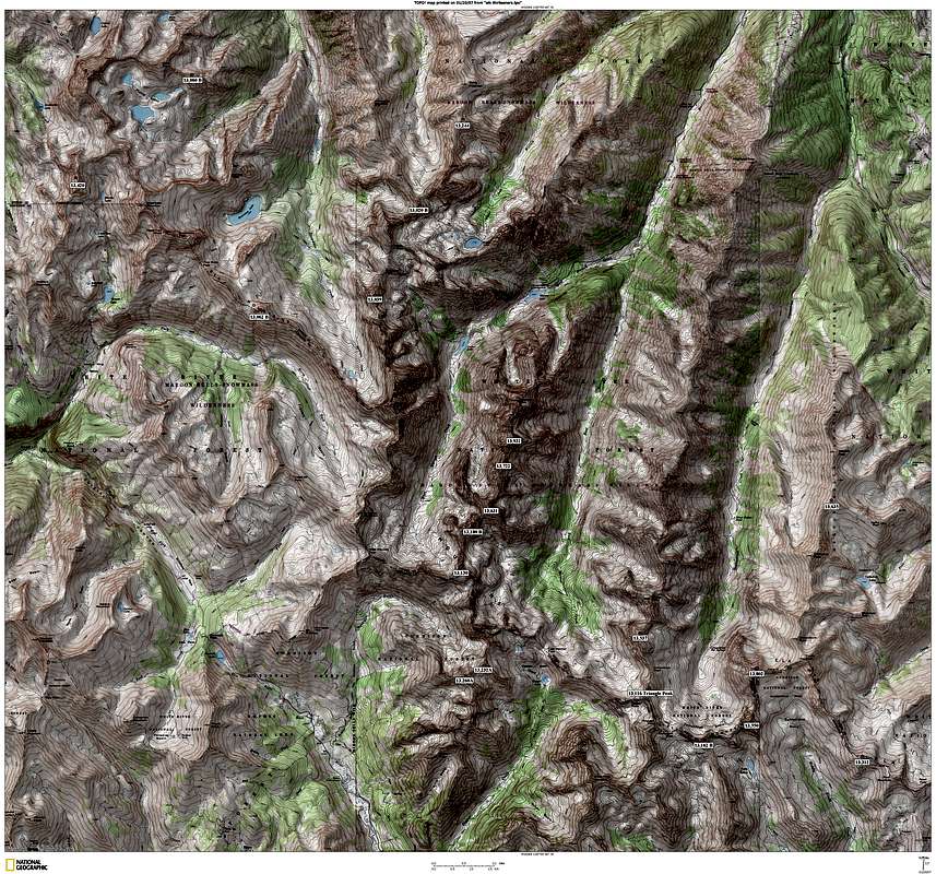
Ranked Twelvers & Thirteeners of the Elk Range
An official USGS Topo of every hard ranked twelver and thirteener in the Elk Mountain Range. Level 4 detail. The Elk Range hosts 103 hard ranked peaks over 12,000-ft.The yellow star indicates a twelver. A red star indicates a thirteener. Of course the fourteeners are in white.
Furthest north Twelver Mount Sopris.
Furthest south Twelver Middle Baldy.
Furthest east Twelver Chair Mountain.
Furthest west Twelver Matchless Mountain.
Super Hikes
East Maroon Valley-Conundrum Valley Half-Circle
Trailhead:
·Conundrum TH or East Maroon TH
Car Shuttle:
·Yes
Hiking Distance:
·RT-22 miles
Vertical Gain:
·4,600-ft
High Point:
·Triangle Pass at 12,900-ft
Highlights:
·Visit two stunning drainages
·Conundrum Hot Springs
·Triangle Pass & Copper Pass
·Interesting perspective of the Pyramid Peak massif

Fravert Basin Loop Hike
Trailhead:
·Maroon Lake TH
Car Shuttle:
·No
Hiking Distance:
·RT 23.4 miles
Vertical Gain:
·7,360-ft
High Point:
·12,500-ft at West Maroon Pass
Highlights:
·Expansive views from four mountain passes
·The beauty of Fravert Basin

Electric Pass Loop Hike
Car Shuttle:
·Yes, or hitchhike two miles back to car.
Trailhead:
·Cathedral Lake TH or American Lake TH
Hiking Distance:
·RT 9.3 miles from TH to TH. 2.7 miles in-between TH’s.
Elevation Gain:
·3,800-ft TH to TH.
Highpoint:
·Electric Pass at 13,370-ft
Highlight:
·Two beautiful Alpine Lakes
·Amazing views of Conundrum Valley, Cathedral Peak and other 14ers
·Route finding skills needed, much of the hike is off trail
The Wilderness
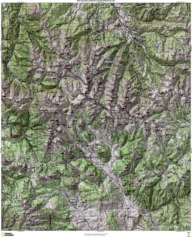
Maroon Bells Snowmass Wilderness
The Maroon Creek Valley
In 1964, Congress recognized the obvious wilderness value of the Elk Mountains, and the Maroon Bells Snowmass wilderness was one of the original five Colorado wilderness areas designated by the Wilderness Act. The first piece of legislature encompassed only the most rugged core of the range. Later in 1980, it took the efforts of Aspen conservationists to expand the area to include such notable landmarks as Mount Sopris, Castle Peak, and the lower reaches of Conundrum Creek valley.
The Maroon Bells-Snowmass Wilderness Area in central Colorado offers up some of the finest and most photographed scenery in Colorado. It is the granddaddy place to be in the Elk Range. For the casual visitor and photographer, the obvious area trophy peaks are the famous Maroon Bells and Pyramid Peak, both accessible by a non-wilderness, paved road to Maroon Lake. For certain, both massifs are well deserving of their respective accolades and recognition. For the more adventurous, a long hike to Snowmass Mountain or Capitol Peak will keep your eyes entertained for hours and hours.
While this area is heavily used during most of the year, venturing off the beaten path potentially allows for even more solitude than you may be looking for.
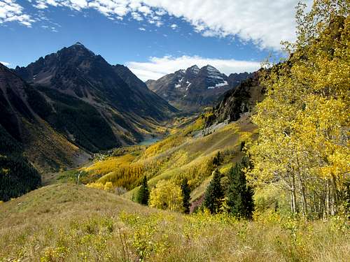
The West Elk Wilderness
The West Elk Wilderness comprises a remote and mountainous area west of Gunnison Colorado. The West Elks encompasses 176,000 acres of Gunnison National Forest, making it the fifth largest wilderness in Colorado. This region resides south of Kebler Pass, which runs east from Paonia State Recreation to the tiny ski resort of Crested Butte, and south to the Curecanti National Recreation Area. The volcanic ridges and long valleys offer extensive hiking and climbing. Over 200 miles of constructed trails are available for both foot and horse travel through this sometimes-rugged terrain. Elevations within the Wilderness range from 7,000 to over 13,000 feet. Because the area lacks fourteeners, centennial thirteeners and numerous alpine lakes you will get the benefit of hiking alone and away from the typical recreational visitor.
From late September into early October, nothing beats the West Elks for fall color. Photographers, hikers and climbers are rewarded with a dazzling display of golden fall foliage. The nearby Curecanti Recreation Area and Uncompahgre Wilderness also share the same climate, a dry climate that varies greatly from day to night and provides minimal precipitation. During spring or summer, freezing morning temperatures quickly make room for afternoon warmer temps; it’s not uncommon to feel a 20-degree swing from the shadows to the sun. This cool and dry climate is perfect for aspen groves, russet Gamble’s oak, maroon-colored serviceberry and mountain mahogany. In addition, the climate works well for wildlife including elk, mule deer, black bear, bobcat, mountain lion, and coyote.
In addition to the great fall foliage, the West Elks are outlined with charming small towns like Crested Butte, Crawford, Hotchkiss, Paonia and Somerset. All of these tiny towns offer an extensive network of dirt roads that escort you into the heart of the Wilderness. These roads have a reputation for being rough, muddy and rutted-out, especially after any recent precipitation. Also, be aware of roaming cattle.
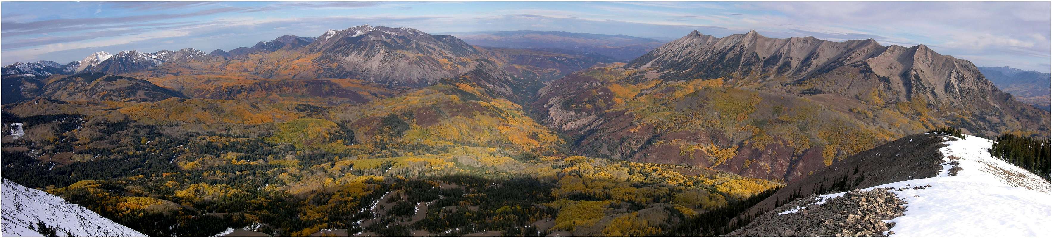
The Raggeds Wilderness
per Jon Bradford
Colorado's Ragged Wilderness
The Raggeds Wilderness is a unique and exciting country resplendent with rugged peaks, gothic cliffs, and colors that strain perceptions. This is the land where purple, maroon, grey, and shinning white rocks rise above alpine carpets of lush iridescent green and vast tracts of gigantic aspen. Reminescent of the landscape of the nearby Maroon Bells-Snowmass Wilderness, the Raggeds Wilderness offers a less crowded alternative. In spite of the similarities, the Raggeds are distinctive. Three geologically different sub-ranges of the mighty Elk Range compose the Raggeds Wilderness; and this topographic variety gives the region a distinctive flair. Amongst the mountain splendor are scenic showcases of geological wonder. Features like The Grand Dyke, Dark Canyon, and Oh-Be-Joyfull Basin delight the eye.
The Raggeds Wilderness was designated in 1980 and contains 65,019 protected acres. It is located 11 miles west of the town of Crested Butte. It is bounded on the east by Schofield Pass, on the south by Kebler Pass, on the west by Colorado Highway 133, and on the north by the Crystal River. Within these confines the Ragged Range occupies the northwestern part of the wilderness with soaring and appropriately ragged ridges of Tertiary intrusives. The highpoint of the Raggeds is Chair Mountain (12,721-ft). The eastern portion of the wilderness is occupied by the twin massif’s of Treasury Mountain (13,462-ft) and Treasure Mountain (13,528-ft). This huge dome of layered marine shale’s is sculpted with five majestic cirques that drop off the north east of the mountains. Treasure Mountain is the highest point within the Raggeds Wilderness. Herein I refer to the massif as The Treasures. The southeastern section of the wilderness contains the seven-mile long Ruby Range. This linear range of stratified Pennsylvanian aged sediments lives up to its name. From Purple Mountain near Yule Pass to Ruby Peak this line of summits stands as a colorful encore to the higher Maroon Bells to the east. The highpoint of the Ruby Range is 13,058 ft. Mount Owen.
Skiing the Elks
per Brian Kalet| Peak | Route | Difficulty |
| Castle Peak A | East Face | Extreme, D14 (1-2) |
| Northeast Ridge | Intermediate (1-2) | |
| North Face Couloir | Advanced (1-2) | |
| Northwest Ridge | Intermediate (1-2) | |
| From Conundrum Hot Springs | Intermediate (1) | |
| From Cumberland Basin | Intermediate (1) | |
| South Maroon Peak | East Face | Extreme, IV D16 R3 (3) |
| Bell Cord Couloir | Extreme, IV D14 R2 (3) | |
| Original East Couloir | Extreme, IV D11 R2 (3) | |
| Alternate East Couloir | ? (3) | |
| Southwest Face Direct | Extreme (1) | |
| Capitol Peak | Knife Ridge | Extreme, V D16 R4 (4) |
| East Face | Extreme, V D21 R5 (4) | |
| Snowmass Mountain | From Snowmass Lake | Intermediate (1) |
| West Face Direct | Extreme, D12-14 (5) | |
| Conundrum Peak | South Ridge | Intermediate (1) |
| Conundrum Couloir | Advanced, D9 (1-2) | |
| Pyramid Peak | East Face | Extreme, IV D20 R4 (6) |
| North Maroon Peak | Northeast Ridge | Extreme, IV D16 R4 (7) |
| North Face Direct | Extreme, IV D15 R3 (3) | |
| Gunsight Ridge | Extreme (1) | |
| North Face & West Face Combo | Extreme (1) | |
| Cathedral Peak A | East Face | Extreme, D14 (2) |
| Lisa Couloir | Extreme, S5 (8) | |
| Pearl Couloir | Extreme, S5- (8) | |
| "Thunder Pyramid" | West Face via White Couloir | Extreme, D16-D19 (9-10) |
| East Face | Extreme, D19 (11) | |
| "Lightning Pyramid" | East Face | Extreme, D15 (12) |
| West Face | Extreme, D14 (13) | |
| Electric Pass Peak | South Face | Extreme, D10 (2) |
| Hayden Peak | North Face | Extreme, S5- (2,8) |
| Treasure Mountain A | Northwest Ridge | Advanced, S4 (8) |
| West Face | Advanced, S4+ (8) | |
| West Face Direct | Advanced, III D9 (2) | |
| Treasure Mountain Couloirs | Extreme, S5- (8) | |
| Star Peak | June Couloir | Advanced, S4+ (8) |
| East Ridge | Advanced, S3 (optional S5-) (8) | |
| Pearl Mountain | North Face | Advanced, S3+ (2,8) |
| Malamute Peak | Southwest Ridge | Advanced, S4-(8) |
| West Pearl Mountain | North Face | Advanced, S4- (2,8) |
| Purple Mountain | South Face | Advanced, D8 (2) |
| Mount Sopris | Northeast Ridge | Advanced, S3+ (8) |
| Thomas Lakes Bowl | Advanced, S3 (8) | |
| Nettle Creek Cirque | Advanced, S3+ (8) | |
| Crystal Chute | Advanced, S5-, IV D9 R3 (8,11) | |
| Augusta Mountain | Southeast Face | Advanced, D9 (2) |
| Greg Mace Peak | North Couloirs | Extreme, S4+ (2,8) |
| Mineral Point A | West Ridge | Advanced, D6 (2) |
| East Face | ? | |
| Mount Emmons | Red Lady Bowl | Advanced, II D8 (2,14) |
| Southeast Ridge | Intermediate, II D5 (2,14) | |
| West Side Gully | Intermediate, II D5 (14) | |
| Red Lady Glades | Intermediate, II D5 (14) | |
| Whitehouse Mountain | Northwest Face | Advanced, S4+ (2,8) |
| West Face | Advanced, S4 (8) | |
| Marble Peak | East Bowl | Advanced, S3-, II D5 R1 (2,8,15-16) |
| Bears Point | Boyfriend Ridge | Advanced, S3 (8) |
| Girlfriend Glade | Advanced, S3- (8) | |
| Riley 1 | Advanced, S4 (8) | |
| Riley 2 | Advanced, S3+ (2,8) | |
| Riley 3 | Advanced, S3 (2,8) | |
| Riley Bowl | Advanced, S3+ (2,8) |
S System
D System
References
1. Dawson's Guide to Colorado Fourteeners Vol. 1: The Northern Peaks
2. Personal observations
3. http://www.wildsnow.com/?p=201
4. http://www.wildsnow.com/?p=243
5. http://skithe14ers.com/p-snowmass-mtn.php, Chris Davenport, personal communication, October 29, 2008
6. http://www.wildsnow.com/?p=237
7. http://www.wildsnow.com/?p=252
8. Dawson's Guide to Colorado Backcountry Skiing, Volume 1
9. Matt Primomo, personal communication, May 15, 2008
10. Dave Bourassa, personal communication, April 3, 2007
11. Chris Davenport, personal communication, October 27, 2008
12. Dave Bourassa, personal communication, October 27, 2008
13. Matt Primomo, personal communication, October 27, 2008
14. Ed Fornataro, personal communication, April 11, 2007
15. http://www.wildsnow.com/articles/ratings/ski-board-d-rating-system.html
16. http://www.wildsnow.com/?p=246
Red Tape
Maroon Bells Snowmass Wilderness
There are no fees to enter or hike this wilderness. However, there are several Colorado wilderness areas that now require a free user permit to be in the wilderness, or shortly will require same. The wilderness areas are Holy Cross, Maroon Bells/Snowmass, Mount Evans, and Mount Massive. Permit tags are available at trailheads and are a two part tag. The white part goes in the box provided and the card portion is to be attached to the outside of your pack. There is currently no penalty if one does not have a permit. However, large fines could be levied within a few years for non-compliance. The preferred method now for dealing with violations is education of the users.
The reason for implementation of this required permit is the Forest Service has been unable to obtain accurate data on use patterns from the voluntary sign-in system. The estimated compliance range is currently 10-30%.
The hope is to obtain better data with this new method. While some may feel this is a precursor of some kind of quota system, the opposite is actually true. Accurate information on visitor use patterns will allow the forest service to attempt to evenly distribute impacts and encourage use of alternate trailheads for the same destinations. However, given the magnitude of the state's continuing population boom, folks should not be surprised if quotas in certain areas become a necessity.
Thanks to SP member mtnhiker13 for supplying this vital update via the Colorado Mountain Club's email service.
(970) 925-3445
White River
National Forest
P.O. Box 948
Glenwood Springs CO 81602
(970)-945-2521
West Elk Wilderness & Raggeds Wilderness
There are no fees to enter or hike this wilderness.
For more information contact:
miztflip - Mar 5, 2006 11:58 pm - Voted 10/10
Fravert Basin LoopHey Kane, just fyi, this is also called the more generic "Four Passes Loop" by trail runners and is considered to be among some of the most difficult and challenging of trail runs.
ajberry - Feb 2, 2007 2:26 am - Voted 10/10
Cathedral-American Lakes LoopIt's possible to do a slight variant on the route suggested - one that allows you to take greater advantage of the fabulous views from the Cathedral-Hayden ridge. Start from the Cathedral Lake trailhead. From Electric Pass Peak, head N directly along the ridge towards Hayden Peak. There are a couple of slightly dodgy segments on the ridge - bad rock and considerable exposure on the Conundrum side - but it's easy enough to get over to Pt 13,540. Then drop down E along the shoulder before heading down to American Lake. Not once, and I've done the route 5 or 6 times, have I succeeded in hitching a lift along the road back the Cathedral Lk trailhead parking lot... Not the best of finishes to an excellent walk that starts and finishes among the summer crowds but boasts an exhilarating centerpiece.