
|
|
Mountain/Rock |
|---|---|
|
|
39.07140°N / 106.95°W |
|
|
14018 ft / 4273 m |
|
|
Elk Mountains Overview

It makes sense dividing the Elk Range into three regions, the famous Maroon Bells Snowmass Wilderness(Maroon Bells, Capitol Peak/Snowmass Mountain, and the Conundrum/Taylor River area), the Raggeds Wilderness (Chair Mountain, Ragged Mountain and the Treasure Mountain massif) and the West Elks Wilderness(the Beckwith’s, the Owens Mountain massif, West Elk massif and the Anthracite Range.) Combined, all three regions provide the perfect introduction into Colorado's spectacular backcountry.
The high mountains of Colorado’s Elk Range are among the finest peaks in the Rockies. With Wilderness designation, these protected mountains are rugged, steep and aesthetically pleasing. Crystal clear streams, pristine alpine lakes and lush green vegetation are common sights. 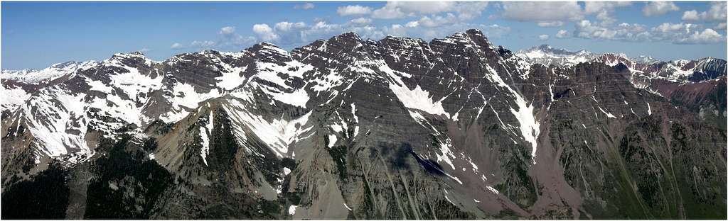
The beauty of the Elk Range is due to the unique geology. There are two very distinct geological types of rock that are clearly evident in the Elk Mountains, the tertiary intrusives, and the stratified sedimentary. The whitish, gray rock of the tertiary intrusives is responsible for the sweeping, skinny ridges that connect point-to-point, evident in Snowmass Mountain, The Beckwith’s, Capitol Peak and the Chair Mountain massif. Second, the stratified purplish-red, sedimentary rock of the Permian age, evidenced in mountains like Cathedral Peak, Teocalli Mountain, Pyramid Peak, Maroon Bells and "Willow Peak."
Over the years, the Elk Range has have remained in respectably good shape, however some of the northern trails are beginning to show some over-use. Thanks to the Maroon Bells Snowmass Wilderness, we can visit large sections of mountainous terrain knowing not much has changed since early exploration.
Pyramid Peak Overview
As of Aug, 2014 all campsites in the Crater Lake area have been closed due to Bear activity.
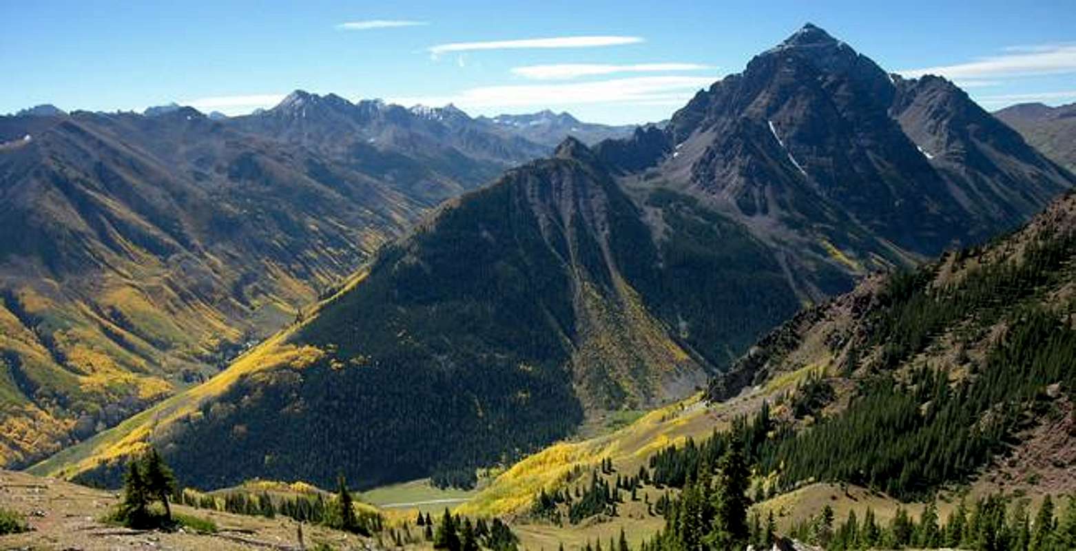
Pyramid Peak is located at the head of the glacier-carved West Maroon Creek Valley. This mountain is about a 13-mile drive from the town of Aspen and is only about 2 miles east of the summits of the Maroon Bells. The geology of Pyramid Peak falls into the crumbling, sedimentary category. All 14,018-ft of this magnificent mountain can be described by “the three R’s,” red, rugged, and rotten. This mountain gets its fitting name from its shape when viewed from the north, northeast. Views of Pyramid Peak from the back of Aspen Highlands ski area and Buttermilk ski area are mesmerizing. When viewing this towering peak from hwy 82 at the Maroon Creek Road junction, it looks like Pyramid Peak is standing guard over the entrance to its protective boundary, the Maroon Bells Snowmass Wilderness.
Also, this route could very well be the steepest sustained route you have ever encountered on a mountain. From the trailhead the standard route is only 3 miles to the summit and will cover 4,430-ft of vertical gain! The route from the trailhead to the 13,000-ft saddle is relentlessly steep class 2+. The last 1000-ft is continuous tough class 3 and class 4 climbing; I really don’t remember any class 2 or "hiking" during that stretch.
The exposure factor depends on your exact route. Sticking to the ridge crest where you will encounter more solid rock, you will have to deal with the 1000-ft drops that Roach talks about in his book. If you decide to gradually ascend through the vertical steps and the sandy cliff bands of the Green Couloir (the “new” standard route) the exposure still exits but to a lesser extent.
I have designated Pyramid semi-dangerous because I thought Maroon Peak to be crumbling to the ground at a faster pace, although Pyramid isn’t far behind. Using a rope on this mountain or bringing your dog really increases the danger factor for others. Many people choose not to wear a helmet in these mountains, obviously unaware of potential rock fall. If you choose not to wear something to protect your head from a speeding rock missile, consider yourself in the same group of people that choose not to wear a helmet when riding a motorcycle, it’s that simple. There is no need to mess around with the “law of averages” on this mountain for its steep and loose slopes are dangerous enough. In summery, do the Northeast Ridge Route with a small party, on a weekday, and get an early alpine 4:00 a.m. start and the “danger factor” drops considerably.
Starting June 14th 2008, Maroon Creek Road restrictions will start and visitors will be directed to RFTA bus service. Buses from Aspen Highlands arrive at Maroon Lake every 20 to 30 minutes. All day users will be required to ride the bus between 9 a.m. and 5 p.m. The bus fare is $6 per adult and $4 per senior and child.
During these hours a shuttle can take you to the trailhead from Ruby Park in downtown Aspen. The shuttle ride is free. Call RFTA at 970-925-3445 or the White River National Forest at 970-925-3445 for schedules.
Author: big_g
Date: Aug 08, 2005 8:19 PM
The road up to the trailhead is restricted to day trippers only. Backpackers and climbers are welcome to drive up (in case they need to exit due to emergency after the shuttle service has stopped).
No promises that you'll find a spot at the end of the road, but you should be able to find something at either the East or West Maroon Wilderness Portals. The bus can be flagged down anywhere to take you the rest of the way.
The following was updated 6-30-2005 by Aaron Johnson
Several Colorado wilderness areas now require a free user permit to be in the wilderness, or shortly will require same. The wilderness areas are Holy Cross, Maroon Bells/Snowmass, Mount Evans, and Mount Massive. Permit tags are available at trailheads and are a two part tag. The white part goes in the box provided and the card portion is to be attached to the outside of your pack. There is currently no penalty if one does not have a permit. However, large fines could be levied within a few years for non-compliance. The preferred method now for dealing with violations is education of the users.
The reason for implementation of this required permit is the Forest Service has been unable to obtain accurate data on use patterns from the voluntary sign-in system. The estimated compliance range is currently 10-30%.
The hope is to obtain better data with this new method. While some may feel this is a precursor of some kind of quota system, the opposite is actually true. Accurate information on visitor use patterns will allow the forest service to attempt to evenly distribute impacts and encourage use of alternate trailheads for the same destinations. However, given the magnitude of the state's continuing population boom, folks should not be surprised if quotas in certain areas become a necessity.
Thanks to SP member mtnhiker13 for supplying this vital update via the Colorado Mountain Club's email service.
Specific information can be viewed here.
Maroon Creek Road
Standard Route Overview
To the casual viewer Pyramid Peak looks unclimbable, most likely because they are viewing its huge, concave north face from the beautiful, tourist-laden Maroon Lake. Upon closer inspection Pyramid Peak can be climbed via a semi-dangerous and loose, class 4 route up the northeast ridge and east face. I would consider this route to be rough and time consuming; completing the route takes longer than the distance would indicate.Also, this route could very well be the steepest sustained route you have ever encountered on a mountain. From the trailhead the standard route is only 3 miles to the summit and will cover 4,430-ft of vertical gain! The route from the trailhead to the 13,000-ft saddle is relentlessly steep class 2+. The last 1000-ft is continuous tough class 3 and class 4 climbing; I really don’t remember any class 2 or "hiking" during that stretch.
The exposure factor depends on your exact route. Sticking to the ridge crest where you will encounter more solid rock, you will have to deal with the 1000-ft drops that Roach talks about in his book. If you decide to gradually ascend through the vertical steps and the sandy cliff bands of the Green Couloir (the “new” standard route) the exposure still exits but to a lesser extent.
I have designated Pyramid semi-dangerous because I thought Maroon Peak to be crumbling to the ground at a faster pace, although Pyramid isn’t far behind. Using a rope on this mountain or bringing your dog really increases the danger factor for others. Many people choose not to wear a helmet in these mountains, obviously unaware of potential rock fall. If you choose not to wear something to protect your head from a speeding rock missile, consider yourself in the same group of people that choose not to wear a helmet when riding a motorcycle, it’s that simple. There is no need to mess around with the “law of averages” on this mountain for its steep and loose slopes are dangerous enough. In summery, do the Northeast Ridge Route with a small party, on a weekday, and get an early alpine 4:00 a.m. start and the “danger factor” drops considerably.
 |
 |
 |
 |
 |
Maoon Lake TH
Approach Pyramid Peak from the Maroon Lake TH (9,590-ft.) From Aspen, locate a round-about a half mile north on Hwy 82 and drive west on Maroon Lake Road for 9.4 miles to the parking area.Starting June 14th 2008, Maroon Creek Road restrictions will start and visitors will be directed to RFTA bus service. Buses from Aspen Highlands arrive at Maroon Lake every 20 to 30 minutes. All day users will be required to ride the bus between 9 a.m. and 5 p.m. The bus fare is $6 per adult and $4 per senior and child.
During these hours a shuttle can take you to the trailhead from Ruby Park in downtown Aspen. The shuttle ride is free. Call RFTA at 970-925-3445 or the White River National Forest at 970-925-3445 for schedules.
Author: big_g
Date: Aug 08, 2005 8:19 PM
The road up to the trailhead is restricted to day trippers only. Backpackers and climbers are welcome to drive up (in case they need to exit due to emergency after the shuttle service has stopped).
No promises that you'll find a spot at the end of the road, but you should be able to find something at either the East or West Maroon Wilderness Portals. The bus can be flagged down anywhere to take you the rest of the way.
The following was updated 6-30-2005 by Aaron Johnson
Several Colorado wilderness areas now require a free user permit to be in the wilderness, or shortly will require same. The wilderness areas are Holy Cross, Maroon Bells/Snowmass, Mount Evans, and Mount Massive. Permit tags are available at trailheads and are a two part tag. The white part goes in the box provided and the card portion is to be attached to the outside of your pack. There is currently no penalty if one does not have a permit. However, large fines could be levied within a few years for non-compliance. The preferred method now for dealing with violations is education of the users.
The reason for implementation of this required permit is the Forest Service has been unable to obtain accurate data on use patterns from the voluntary sign-in system. The estimated compliance range is currently 10-30%.
The hope is to obtain better data with this new method. While some may feel this is a precursor of some kind of quota system, the opposite is actually true. Accurate information on visitor use patterns will allow the forest service to attempt to evenly distribute impacts and encourage use of alternate trailheads for the same destinations. However, given the magnitude of the state's continuing population boom, folks should not be surprised if quotas in certain areas become a necessity.
Thanks to SP member mtnhiker13 for supplying this vital update via the Colorado Mountain Club's email service.
Specific information can be viewed here.
 |
 |
Camping-west of Independence Pass
As of Aug, 2014 all campsites in the Crater Lake area have been closed due to Bear activity.
- Forest service campgrounds in the Aspen area offer everything from primitive camping to RV hookups. Maroon Creek road has three campgrounds, all of which require reservations. Call the number above and expect to pay $15.00 a night. Call as far in advance as possible for a site in this popular area. Those wishing to make reservations should call 1-800-280-CAMP. There is an $8.25 reservation service charge.
Independence Pass Camping
Five campgrounds along Colorado Hwy 82 via Independence Pass offer numerous sites. The following campgrounds are located on the west (Aspen side) side of the pass. - Difficult Campground has 47 sites and is only 5 miles from Aspen. Reservations accepted by number above. $10.00 a night.
- Weller Lake Campground has 11 sites and is 7 miles from Aspen. First come first serve. $10.00 a night.
- Lincoln Gulch Campground has 7 sites and is located 11 miles from Aspen. First come first serve. $10.00 a night.
- Lost Man Campground has nine sites and is 14.5 miles from Aspen. First come first serve. $10.00 a night.
- The best kept secret in the area for camping is up the Lincoln Gulch Road (11 miles from Aspen) past the Lincoln Creek Grattos and close to Grizzly Reservoir where camping along this rough road is free. This is not a road for trailers.
Red Tape
No fees are required if you travel to the TH before 8:30 a.m, although you may need to pay the $10 per car if entering between 6 AM and 8 PM during the day. A parking pass is not required if you enter the park at off hours (see above). Also, in winter the road is gated 3 miles from CO 82 at the T-Lazy 7 Ranch.
Mountain Conditions/When to Climb
- Conditions on this mountain, like all Colorado 14ers, are subject to change rapidly- especially during the prime climbing summer season. The mountains are their own weather system, and weather forecasts from nearby towns often have little to do with actual mountain conditions. You can generally count on clear to partly cloudy in the morning, and heavy clouds and thunderstorms in the afternoon during the summer climbing season.
- There is no substitute for getting an early start, and getting as much of the mountain "behind you" as early in the day as possible. Keep a good eye on the sky as weather conditions can deteriorate rapidly. The greatest weather danger is from lightning strikes, and climbers are killed almost every summer in Colorado by lightning strikes. Late July and August seem to be the most deadly month for lightning.
- Pyramid Peak is usually climbed between June and September. Pyramid would be extremely difficult in the winter. Also try to climb during the week , making it possible to avoid the large weekend crowds, this will lower the rock fall danger. Colorado is famous for afternoon thunderstorms so be sure to be off higher ground by noon.
Maps and Contact Information
Maps: Maroon Bells, White River National Forest
Aspen Ranger District Office
(970) 925-3445
USDA Forest Service
White River
National Forest
P.O. Box 948
Glenwood Springs CO 81602
(970)-945-2521
DMP
DMP
External Links
- Pyramid Peak
- Pyramid Peak (07/30/2005)
- 14ers.com - The Home of Colorado's Highest Peaks
Fourteener Photos, Route Descriptions, Forum, and more...
- Pyramid Peak
Sarah Simon - Dec 22, 2008 10:45 pm - Voted 10/10
Standard Route Overview SectionKane, As a courtesy, I wanted to point out the following spelling boo-boo in the last paragraph of the above-mentioned section: In summery, Not trying to be a pain, just doing this as a courtesy. Sarah
Sarah Simon - Dec 22, 2008 10:47 pm - Voted 10/10
Sorry, one moreKane, Another courtesy spelling boo-boo to call out in the following section header: Maoon Lake TH Cheers, Sarah